
Miyagi Prefecture
|
Miyagi-ken 宮城 県 |
|
|---|---|
  |
|
| Basic data | |
| Administrative headquarters : | Sendai |
| Region : | Tōhoku |
| Main island : | Honshu |
| Area : | 7,282.29 km² |
| Water content: | 0.3 % |
| Residents : | 2,303,160 (October 1, 2019) |
| Population density : | 316 inhabitants per km² |
| Counties : | 10 |
| Municipalities : | 35 |
| ISO 3166-2 : | JP-04 |
| Governor : | Yoshihiro Murai |
| Website: | www.pref.miyagi.jp |
| Symbols | |
| Prefecture flag : |
 |
| Prefecture tree : | Japanese zelkove |
| Prefecture flower : | Lespedeza thunbergii |
| Vogel prefecture : | goose |
| Prefecture mammal : | Sika deer |
| Prefecture song : |
Kagayaku kyōdo ("Radiant Home") |

The Miyagi prefecture ( Jap. 宮城県 , Miyagi-ken ) is a Japanese prefecture . It is located in the Tōhoku region in the northeast of the main island of Honshū . The seat of the prefecture administration is Sendai .
geography
Miyagi Prefecture forms the central part of the Tōhoku region and borders the Pacific Ocean . Miyagi is bordered by Iwate Prefecture to the north, Yamagata and Akita Prefectures to the west, and Fukushima Prefecture to the south .
The coast of Miyagi can be divided into two regions: from the north with the Karakuwa Peninsula to the Oshika Peninsula , the Sanriku Coast with its ria and then the Sendai Bay with the capital of the same name, Sendai in the center. The Oshika Peninsula is surrounded by the Oshika Islands , with only Aji , Enoshima , Izu , Kinkasan, and Tashiro being inhabited. Kinkasan is also the largest island in the prefecture, followed by Ōshima on the Karakuwa Peninsula and Miyato between Ishinomaki Bay and Matsushima Bay , which are also part of Sendai Bay. The bay of Matsushima with its numerous pine islands is counted among the three most beautiful landscapes in Japan .

Miyagi Prefecture outline
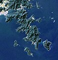
Oshika Peninsula and Islands

Road signs in Miyagi Prefecture


history
Miyagi prefecture roughly corresponds in size to the premodern Rikuzen province . It was founded together with the current borders in 1872.
Disaster caused by the Tōhoku earthquake and tsunami in 2011
The prefecture was hit hard on March 11, 2011 by the aftermath of the Tōhoku earthquake and the tsunami that triggered it. According to the damage record as of March 2016, over 10,500 dead and more than 1,200 still missing were counted for the entire prefecture. 83,000 residential buildings were completely destroyed and 155,000 partially destroyed and 224,000 additional damage to residential buildings was recorded.
| local community | Exposed buildings | Washed away | Quota [%] |
|---|---|---|---|
| Kesennuma | 13,951 | 8,047 | 57.7 |
| Minamisanriku | 6,665 | 5,418 | 81.3 |
| Onagawa | 4,607 | 3,459 | 75.1 |
| Ishinomaki | 62,440 | 12,521 | 20.1 |
| Higashimatsushima | 16,860 | 3,171 | 18.8 |
| Shiogama | 8,995 | 373 | 4.1 |
| Matsushima | 695 | 14th | 2.0 |
| Rifu | 187 | 8th | 4.3 |
| Shichigahama | 3,253 | 1,120 | 34.4 |
| Tagajō | 6.310 | 226 | 3.6 |
| Sendai | 13,721 | 4,329 | 31.6 |
| Natori | 5,530 | 2,810 | 50.8 |
| Ivanuma | 5,285 | 1,298 | 24.6 |
| Watari | 8,143 | 2,059 | 25.0 |
| Yamamoto | 5,373 | 2,802 | 52.0 |
| total | 162.015 | 47,655 | 29.4 |

| |||||||||||||||||
Selection of administrative units in Miyagi (red) and adjacent prefectures (yellow) that were affected by the Tōhoku earthquake and subsequent tsunami on March 11, 2011 (in brackets the number of dead and missing as well as the number of completely destroyed residential buildings as of March 2016) |
politics
(as of November 14, 2019)
Former Prefectural MP Yoshihiro Murai has been governor of Miyagi since 2005 . In 2017 he was re-elected as an independent with LDP-Kōmeitō support against the CPY -supported candidate Satoshi Tatara with over 80% of the vote for a fourth term. In the 59-member parliament which remained LDP also in the election in October 2019 with 28 seats by far the strongest party, the JCP fell to five seats and became the KDP exceeded with seven seats as the second strongest party 13 election winners were without party nomination. In eight constituencies there were 16 members, nine of them from the LDP, without a vote due to a lack of opposing candidates. The voter turnout reached a historic low of 34.8%.
In the national parliament , Miyagi is represented by six directly elected members in the House of Representatives, in the Council House Miyagi elects one member per partial election. After the parliamentary elections in 2016 , 2017 and 2019 , Miyagi's directly elected delegation to the national parliament (as of July 2019) consists of five Liberal Democrats and one non-party in the KDP parliamentary group in the House of Representatives and one member each from the KDP and DVP in the Council House.
tourism
The cultural center of Miyagi Prefecture and the other northern prefectures of Japan is the prefecture capital Sendai , which after Saitama is also the largest city north of Tokyo on Honshū. The city is known for its events for the annual "Star Festival" Tanabata on July 7th .
In Matsushima Bay, near the coastal town of Matsushima off the coast of Sendai, there is a collection of around 260 islands, which is considered to be one of the three most beautiful landscapes in Japan .
Administrative division
Since 2016 there are still 35 communities in Miyagi: 14 [district] cities (- shi ) - of which only the capital in a special form for large cities -, 20 [district] cities ( -machi / -chō ) and one village (- mura ) . After the introduction of today's community forms and the major Meiji district reform in 1889, there were initially around 200 communities, in 2000 before the start of the major Heisei district reform, 71.
Remarks:
- For the sake of readability, multi-part place and district names (double places, for differentiation prefixed province / prefecture / district names, cardinal points, etc.) and regional authority suffixes have been separated by a hyphen, the other Romanization practice is inconsistent.
- There are areas with an unclear course of the municipal boundaries; the prefectural border between Miyagi and Yamagata is also affected.
| local community | Type | Circle (- gun ) | Area (October 1, 2019) |
Population ( October 1, 2019) |
Greater region (division of the prefecture administration) |
|---|---|---|---|---|---|
|
Sendai (seat of the prefecture administration) |
-shi ( designated city ) | - | 786.35 km² | 1,090,263 | Sendai Metro |
| Ishinomaki | -shi | - | 554.55 km² | 141.293 | Ishinomaki |
| Shiogama | -shi | - | 17.37 km² | 52,619 | Sendai Metro |
| Kesennuma | -shi | - | 332.44 km² | 60,840 | Kesennuma / Motoyoshi |
| Shiroishi | -shi | - | 286.48 km² | 33,380 | Sennan |
| Natori | -shi | - | 98.17 km² | 78,796 | Sendai Metro |
| Kakuda | -shi | - | 147.53 km² | 28,623 | Sennan |
| Tagajō | -shi | - | 19.69 km² | 61,985 | Sendai Metro |
| Ivanuma | -shi | - | 60.45 km² | 44,409 | Sendai Metro |
| Tome | -shi | - | 536.12 km² | 77,795 | Tome |
| Kurihara | -shi | - | 804.97 km² | 65,313 | Kurihara |
| Higashi Matsushima | -shi | - | 101.31 km² | 39,138 | Ishinomaki |
| Ōsaki | -shi | - | 796.81 km² | 128,972 | Ōsaki |
| Tomiya | -shi | - | 49.18 km² | 51,889 | Sendai Metro |
| Zaō | -machi | Ring-tailed lemur | 152.83 km² | 11,564 | Sennan |
| Shichikashuku | -machi | Ring-tailed lemur | 263.09 km² | 1307 | Sennan |
| Ōgawara | -machi | Shibata | 24.99 km² | 23,729 | Sennan |
| Murata | -machi | Shibata | 78.38 km² | 10,858 | Sennan |
| Shibata | -machi | Shibata | 54.03 km² | 38,813 | Sennan |
| Kawasaki | -machi | Shibata | 270.77 km² | 8575 | Sennan |
| Marumori | -machi | Igu | 273.3 km² | 12,823 | Sennan |
| Watari | -chō | Watari | 73.6 km² | 32,956 | Sendai Metro |
| Yamamoto | -chō | Watari | 64.58 km² | 11,890 | Sendai Metro |
| Matsushima | -machi | Miyagi | 53.56 km² | 13,468 | Sendai Metro |
| Shichigahama | -machi | Miyagi | 13.19 km² | 18,108 | Sendai Metro |
| Rifu | -chō | Miyagi | 44.89 km² | 35,597 | Sendai Metro |
| Taiwa | -chō | Kurokawa | 225.49 km² | 28,609 | Sendai Metro |
| Ōsato | -chō | Kurokawa | 82.01 km² | 7871 | Sendai Metro |
| Ōhira | -mura | Kurokawa | 60.32 km² | 5874 | Sendai Metro |
| Shikama | -chō | Kami | 109.28 km² | 6745 | Ōsaki |
| Kami | -machi | Kami | 460.67 km² | 22,241 | Ōsaki |
| Wakuya | -chō | Tōda | 82.16 km² | 15,677 | Ōsaki |
| Misato | -machi | Tōda | 74.98 km² | 24.106 | Ōsaki |
| Onagawa | -chō | Oshika | 65.35 km² | 5822 | Ishinomaki |
| Minami-sanriku | -chō | Motoyoshi | 163.4 km² | 11,212 | Kesennuma / Motoyoshi |
| Miyagi | -ken (35 municipalities) | (10 circles) | 7,282.29 km² | 2,303,160 |

Matsushima

Zao


Web links
Individual evidence
- ↑ a b 平 成 23 年 (2011 年) 東北 地方 太平洋 沖 地震 (東 日本 大 震災) に つ い て (第 153 報) ( Memento from March 10, 2016 on WebCite ) , 総 務 省 消防 庁 (Fire and Disaster Management Agency), 8. March 2016.
- ↑ Shunichi Koshimura, Satomi Hayashi, Hideomi Gokon: The impact of the 2011 Tohoku earthquake tsunami disaster and implications to the reconstruction . In: Soils and Foundations . tape 54 , no. 4 , August 2014, p. 560-572 , doi : 10.1016 / j.sandf.2014.06.002 . (Published online July 22, 2014).
- ↑ Miyagi Prefectural Parliament : Members by parliamentary group , accessed on November 23, 2019.
- ↑ 宮城 県 知事 選 、 現 職 の 村井 嘉浩氏 が 新人 破 り 4 選 . (No longer available online.) In: Yomiuri Shimbun . October 22, 2017, archived from the original on March 5, 2018 ; Retrieved March 4, 2018 (Japanese).
- ↑ 2017 宮城 県 知事 選 . In: NHK Senkyo Web. October 22, 2017. Retrieved October 27, 2019 (Japanese).
- ↑ 2019 宮城 県 議 選 各 党 議席 . In: NHK Senkyo Web. October 27, 2019. Retrieved October 27, 2019 (Japanese).
- ↑ 宮城 県 議 選 の 投票 率 、 過去 最低 の 34.80 % 自 公 な ど 県 政 与 党 が 過半数 維持 . In: Kahoku Shimpō . October 27, 2019. Retrieved October 27, 2019 (Japanese).
- ↑ Kokudo Chiriin : 令 和 元年 全国 都 道 府 県 市区 町 村 別 面積 調 (10 月 1 日 時点) , P. 18: 04 宮城 県 (Japanese), accessed June 23, 2020.
- ↑ Miyagi Prefectural Administration : Map of the regions , map with municipality lettering (Japanese)
Aichi | Akita | Aomori | Chiba | Ehime | Fukui | Fukuoka | Fukushima | Gifu | Gunma | Hiroshima | Hokkaidō | Hyōgo | Ibaraki | Ishikawa | Iwate | Kagawa | Kagoshima | Kanagawa | Kochi | Kumamoto | Kyoto | Mie | Miyagi | Miyazaki | Nagano | Nagasaki | Nara | Niigata | Ōita | Okayama | Okinawa | Osaka | Saga | Saitama | Shiga | Shimane | Shizuoka | Tochigi | Tokyo | Tokushima | Tottori | Toyama | Wakayama | Yamagata | Yamaguchi | Yamanashi
Coordinates: 38 ° 21 ' N , 140 ° 58' E