
Plouhinec (Finistère)
| Plouhinec | ||
|---|---|---|
.svg)
|
|
|
| region | Brittany | |
| Department | Finistère | |
| Arrondissement | Quimper | |
| Canton | Douarnenez | |
| Community association | Cap Sizun-Pointe du Raz | |
| Coordinates | 48 ° 1 ′ N , 4 ° 29 ′ W | |
| height | 0-104 m | |
| surface | 28.05 km 2 | |
| Residents | 3,975 (January 1, 2017) | |
| Population density | 142 inhabitants / km 2 | |
| Post Code | 29780 | |
| INSEE code | 29197 | |
 Bay of Pors Poulhan, the port of Plouhinec |
||

Plouhinec ( Breton Ploeneg ) is a commune in western France in the Finistère department in the Brittany region . It has 3975 inhabitants (as of January 1, 2017) and an area of 28.05 km² and is located on the road from Pont-l'Abbé to Audierne .
Population development
| year | 1962 | 1968 | 1975 | 1982 | 1990 | 1999 | 2006 | 2017 |
| Residents | 6036 | 5792 | 5361 | 4900 | 4524 | 4106 | 4177 | 3975 |
| Sources: Cassini and INSEE | ||||||||
Attractions
Sights of the community include u. a. two churches like the Church of Saint-Winoc from the 16th century and the Église Saint Julien from 1885 in the district Poulgoazec that overlooks the harbor of the near Audierne. In addition, there are two chapels from the 16th century, the Chapelle Saint Tugdual (Lanbadu) and the hidden Chapelle Saint They, as well as several fountains and historical washhouses that were previously venerated as saints. The picturesque, small natural harbor is located in the district of Pors-Poulhan. White sandy beaches with a shallow, slowly deepening sea and gentle surf are ideal for families with children. The Chateau / Manoir Lescongar is located in the municipality of Plouhinec near the Route de Pont-Croix, which runs as the D2 from Pont-Croix to Plozévet . From this section of the D2, two historic, picturesque avenues lead to this private property from the 17th century. Their former, now renovated caretaker's house is offered as a holiday home. On the grounds of the Manoir Lescongar, a tumulus , a barrow made of stones or earth, from the Bronze Age was uncovered. Nearby is the 35-hectare Étang de Poulguido, with a depth of around 1.50 m, it is characterized by a botanical and ornithological diversity and abundance of fish. The avenue Couverte de Pors Poulhan Menez-Korriged of megalithic culture near the natural harbor of the same name Pors Poulhan is another attraction of the municipality of Plouhinec. The picturesque little fishing port marks the border of the Bigoudenland and the Cap Sizun. The Allée Couvert denotes graves that do not have a burial chamber, but consist of a single, covered burial passage. This one stands above the cliff between the port and the Pointe de Souc'h. After the Second World War, this historic site was faithfully restored using old photographs and sketches. The 15-meter-long Allée Couvert, with its pointed stone slab border, resembles the bow of a ship.
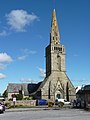
Saint Winoc Church of Plouhinec

Saint Julien Church in the Poulgoazec district
Saint They Chapel in Plouhinec
Allée Couverte Menez Corrected Pors Poulhan

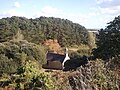
Corps de garde de la pointe du Souc'h at Plouhinec

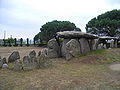
Dolmen of the necropolis at the Pointe de Souc'h near Plouhinec

Pors Poulhan, the port of Plouhinec foreground Four à goémon

Access to the Manoir de Lescongar in the municipality of Plouhinec
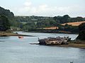
Ship cemetery at Goyen in the municipality of Plouhinec
.JPG)


.JPG)

.JPG)


literature
- Le Patrimoine des Communes du Finistère. Flohic Editions, Volume 2, Paris 1998, ISBN 2-84234-039-6 , pp. 1169-1173.