
Osaka prefecture
|
Ōsaka-fu 大阪 府 |
|
|---|---|
  |
|
| Basic data | |
| Administrative headquarters : | Osaka |
| Region : | Kinki |
| Main island : | Honshu |
| Area : | 1,905.29 km² |
| Water content: | 17.9 % |
| Residents : | 8,823,453 (October 1, 2019) |
| Population density : | 4631 inhabitants per km² |
| Counties : | 5 |
| Municipalities : | 43 |
| ISO 3166-2 : | JP-27 |
| Governor : | Hirofumi Yoshimura |
| Website: | www.pref.osaka.jp |
| Symbols | |
| Prefecture flag : |
 |
| Prefecture tree : | ginkgo |
| Prefecture flower : | Ume , Siebold's primrose |
| Vogel prefecture : | Buffalo head shrike |
The Osaka Prefecture ( jap. 大阪府 , new outlet fu ) is a prefecture of Japan . It is located in the Kinki region on the island of Honshu . The seat of the prefecture administration is the city of the same name Osaka .
geography
Osaka Prefecture is located on the coast of Osaka Bay . The Osaka Plain (heisaka heiya) takes up a large part of the prefecture and extends into the adjacent Hyōgo to the northwest. In the plain lies with the cities of Osaka and Kobe (together Hanshin ) an essential part of the Keihanshin metropolitan region, which is the second largest metropolitan area in the country after the metropolitan region of Kantō around Tokyo and the heart of western Japan . The Hokusetsu Mountains and the Tanba Highlands rise in the north of Osaka Prefecture. From the northeast, the Yodo-gawa flows from Kyoto through the plain and the city of Osaka. The Ikoma Mountains rise to the east, where Osaka borders on Nara. From there comes another larger river, the Yamatogawa , and flows through the south of the Osaka plain, at its mouth it forms the border between the cities of Osaka and Sakai, the second major city in the prefecture. In the southeast, the Kongō Mountains limit the Osaka Plain. The Izumi chain rises to the south, where Osaka borders on Wakayama.

outline

Physical card

Congregation (as of 2015)


history
The Osaka prefecture was established in 1868 as the successor to the former shogunate administration for the city of Osaka (Ōsaka-machi- bugyō ) . After the abolition of the Han , the feudal fiefdom, in 1871, it roughly comprised the northern third of its present-day area. In 1881, the Osaka Prefecture annexed the Sakai Prefecture , its territory expanded to include the current area and also the present Nara Prefecture , which was not finally separated from Osaka until 1887. Since then, Osaka prefecture has largely included the provinces of Kawachi , Izumi and part of Settsu .
politics
(as of May 14, 2019)
- Osaka Ishin no Kai : 51
- Jiyūminshutō ・ mushozoku (" Liberal Democratic Party , Independents"): 16
- Kōmeitō : 15
- KPY : 2
- Minshu Net ("Democratic Network"; KDP , Independent): 2
- One-man parliamentary groups: 2
As in all prefectures, the governor, who is directly elected every four years, is at the head of the Osaka prefectural administration. In March 2019, the previous governor of Osaka, Ichirō Matsui ( Ōsaka Ishin no Kai & chairman of the national Nippon Ishin no Kai), and at the same time the mayor of Osaka City, Hirofumi Yoshimura (Ōsaka Ishin), resigned in order to hold new elections at the same time as the unified elections in 2019 to win a new mandate for the Osaka-to- Plan. Yoshimura was running for governor of the prefecture, Matsui for mayor of the city. The candidacy swap took place in order to avoid denaoshi-licho ("new beginning elections ") and to be elected for a full four years in the event of victory. Both won, Yoshimura won the gubernatorial election with over 64% of the vote. At the same time, Osaka Ishin no Kai was able to win an absolute majority in the 88-member prefectural parliament again, as in 2011 .
The Ōsaka-to- plan pursued by the Ishin no Kai ( 大阪 都 構想 , Ōsaka-to kōsō , mostly translated as "Osaka Metropolis plan" into English) describes the dissolution of the city of Osaka into "special districts" ( tokubetsu-ku ) of the prefecture Osaka similar to Tokyo prefecture. Osaka would then functionally like Tokyo a -to (~ "[metropolitan / capital] prefecture") instead of previously -fu ("[city] prefecture"), even if national laws allow the abolition of the city of Osaka, but do not provide for a renaming of the prefecture. Originally, Ishin no Kai also wanted to dissolve Osaka's second city, Sakai, and other surrounding communities into “special districts”, but after political setbacks, a first to plan was made that was limited to the city of Osaka; this first plan was rejected by a narrow majority of the citizens of Osaka city in a referendum in May 2015. After the Ishin double election victory in 2019, the Kōmeitō Osaka announced that it would agree to another referendum. The second half of 2020 is announced as the date. The LDP also later signaled its approval of holding a new referendum. In June 2019, an Ishin no Kai candidate also won Sakai's mayoral election; but at least in the short term, the city shouldn't be part of the plan.
In the national parliament , Osaka is represented by 19 directly elected members of the lower house and eight in the upper house . After the 2017 election , a by-election in 2019 and party changes since then, the 19 lower house constituencies of Osaka are composed of nine Liberal Democrats, four members of the Kōmeitō , three of the Nippon Ishin no Kai and one each from the Constitutional Democratic Party , the People's Democratic Party and the "Party for the Protection of the People before the NHK" represented. For the upper house, Osaka is a four-seat constituency, so it is represented by eight MPs. After the 2016 and 2019 elections, Osaka's representatives are four Ishin MPs and two members each from the LDP and Kōmeitō.
Administrative division
With the introduction of the modern communities in 1889, Osaka prefecture consisted of two independent cities ( - shi from previously 5 city districts, - ku , four became districts of the new city of Osaka, Sakai-ku became Sakai-shi ), twelve small towns ( -machi / -chō ) and 310 villages ( - mura ) in 27 counties. As a result of incorporations and mergers, the number of municipalities fell from 296 (1920) to 104 (1955) and 51 (1960) to 44 in 1975. Since 2005, the prefecture has consisted of 33 [independent] cities, nine small towns and one village, the latter combined in five counties. Two of these districts consist of only one municipality each.
There are eleven -shi in the three special forms for large cities:
- "Designated cities" ( seirei shitei toshi ): Osaka and Sakai;
- "Core cities" ( chūkakushi ): Higashiōsaka, Hirakata, Takatsuki, Toyonaka, Yao and Neyagawa;
- “Exceptional Cities ” ( tokureishi ): Ibaraki, Kishiwada and Suita.
In the table below, the districts (- gun ) are shown in italics, below each (indented) the small towns and the village within them. The first three digits of the authority code (1st column) depend on the prefecture and type of authority: The first two digits are the prefecture key (Osaka is JP-27), the third digit is 0 for prefectures, 1 for designated cities and special districts, 2 for other independent cities, 3–7 for other municipalities [historically belonging to the district] as well as for the district codes used for statistical purposes, 8 for special purpose associations. The independent cities are at the beginning of the table.

| code | Surname | Area (in km²) | population | Population density (inh / km²) 3 |
||
|---|---|---|---|---|---|---|
| Latin transcription | yep | 1st October 2019 | 1st October 2019 | October 1, 2015 3 | ||
| 27100 | Osaka-shi | 大阪 市 | 225.3 | 2,740,202 | 2,691,185 | 11944.90 |
| 27140 | Sakai- shi | 堺 市 | 149.82 | 827.971 | 839.310 | 5602.12 |
| 27202 | Kishiwada- shi | 岸 和田 市 | 72.72 | 189,811 | 194,911 | 2680.29 |
| 27203 | Toyonaka- shi | 豊 中 市 | 36.39 | 400,329 | 395.479 | 10867.79 |
| 27204 | Ikeda- shi | 池田 市 | 22.14 | 104.169 | 103.069 | 4655.33 |
| 27205 | Suita- shi | 吹 田 市 | 36.09 | 381,829 | 374,468 | 10375.95 |
| 27206 | Izumi-Ōtsu-shi | 泉 大 津市 | 14.31 | 74,566 | 75,897 | 5296.37 |
| 27207 | Takatsuki- shi | 高 槻 市 | 105.29 | 348.247 | 351,829 | 3341.52 |
| 27208 | Kaizuka- shi | 貝 塚 市 | 43.93 | 85,860 | 88,694 | 2018.98 |
| 27209 | Moriguchi- shi | 守 口 市 | 12.71 | 142,262 | 143,042 | 11254.29 |
| 27210 | Hirakata- shi | 枚 方 市 | 65.12 | 399.197 | 404.152 | 6206.27 |
| 27211 | Ibaraki- shi | 茨 木 市 | 76.49 | 282.825 | 280.033 | 3661.04 |
| 27212 | Yao-shi | 八 尾市 | 41.72 | 266,386 | 268,800 | 6442.95 |
| 27213 | Izumi-sano-shi | 泉 佐野 市 | 56.51 | 100,239 | 100,966 | 1786.69 |
| 27214 | Tondabayashi- shi | 富田 林 市 | 39.72 | 110.132 | 113.984 | 2869.69 |
| 27215 | Neyagawa- shi | 寝 屋 川 市 | 24.7 | 229,974 | 237,518 | 9616.11 |
| 27216 | Kawachi-Nagano-shi | 河内 長野 市 | 109.63 | 102.102 | 106,987 | 975.89 |
| 27217 | Matsubara- shi | 松原 市 | 16.66 | 118,340 | 120,750 | 7247.90 |
| 27218 | Daitō- shi | 大 東 市 | 18.27 | 119.986 | 123.217 | 6744.23 |
| 27219 | Izumi-shi | 和 泉 市 | 84.98 | 185.208 | 186.109 | 2190.03 |
| 27220 | Minō- shi | 箕 面市 | 47.9 | 136.184 | 133,411 | 2785.20 |
| 27221 | Kashiwara- shi | 柏 原 市 | 25.33 | 68,400 | 71.112 | 2807.42 |
| 27222 | Habikino- shi | 羽 曳 野 市 | 26.45 | 109,553 | 112,683 | 4260.23 |
| 27223 | Kadoma- shi | 門 真 市 | 12.3 | 119,692 | 123,576 | 10046.83 |
| 27224 | Settsu- shi | 摂 津市 | 14.87 | 86.004 | 85.007 | 5716.68 |
| 27225 | Takaishi- shi | 高 石 市 | 11.3 | 56,320 | 56,529 | 5002.57 |
| 27226 | Fujiidera- shi | 藤井 寺 市 | 8.89 | 63,814 | 65,438 | 7360.85 |
| 27227 | Higashi-Ōsaka-shi | 東 大阪 市 | 61.78 | 494,640 | 502.784 | 8138.30 |
| 27228 | Sennan -shi | 泉 南市 | 48.98 | 60,435 | 62,438 | 1274.77 |
| 27229 | Shijōnawate- shi | 四條 畷 市 | 18.69 | 55,427 | 56,075 | 3000.27 |
| 27230 | Katano- shi | 交 野 市 | 25.55 | 76,100 | 76,435 | 2991.59 |
| 27231 | Osaka-Sayama-shi | 大阪 狭 山 市 | 11.92 | 58,746 | 57,792 | 4848.32 |
| 27232 | Hannan- shi | 阪 南市 | 36.17 | 51,747 | 54,276 | 1500.58 |
| 27300 | Mishima-gun | 三島 郡 | 16.81 | 29,983 | 1783.64 | |
| 27301 | Shimamoto-cho | 島 本 町 | 16.81 | 30,797 | 29,983 | 1783.64 |
| 27320 | Toyono gun | 豊 能 郡 | 133.09 | 30,190 | 226.84 | |
| 27321 | Toyono-cho | 豊 能 町 | 34.34 | 18,441 | 19,934 | 580.49 |
| 27322 | Nose-cho | 能 勢 町 | 98.75 | 9189 | 10256 | 103.86 |
| 27340 | Senboku-gun | 泉 北 郡 | 3.97 | 17,298 | 4357.18 | |
| 27341 | Tadaoka-cho | 忠 岡 町 | 3.97 | 16,840 | 17,298 | 4357.18 |
| 27360 | Sennan-gun | 泉 南郡 | 72.03 | 68,790 | 955.02 | |
| 27361 | Kumatori-cho | 熊 取 町 | 17.24 | 43,884 | 44,435 | 2577.44 |
| 27362 | Tajiri-cho | 田 尻 町 | 5.62 | 8536 | 8417 | 1497.69 |
| 27366 | Misaki-cho | 岬 町 | 49.18 | 15,185 | 15,938 | 324.07 |
| 27380 | Minami Kawachi gun | 南 河内 郡 | 76.72 | 35,252 | 459.49 | |
| 27381 | Taishi-cho | 太子 町 | 14.17 | 13,213 | 13,748 | 970.22 |
| 27382 | Kanan-cho | 河南 町 | 25.26 | 15,751 | 16,126 | 638.40 |
| 27383 | Chihaya Akasaka mura | 千 早 赤阪 村 | 37.3 | 4921 | 5378 | 144.18 |
| Shi-bu (independent cities) | 市 部 | 1,602.67 | 8,657,956 | 5402.71 | ||
| Gun-bu (counties) | 郡 部 | 302.62 | 181,513 | 599.81 | ||
| 27000 | Osaka-fu | 大阪 府 | 1,905.29 | 8,823,453 | 8,839,469 | 4639.80 |
swell
1 Area data from 2018
2 Estimated population 2018
3 Results of the 2015 census
Remarks:
- There is an area with an unresolved border between the cities of Osaka and Toyonaka.
Population development in the prefecture
|
Census - year |
Total population |
male population |
female population |
Gender ratio men to 1000 women |
Area in km 2 |
Population density per km 2 |
|---|---|---|---|---|---|---|
| 1920 | 2,587,847 | 1,344,846 | 1,243,001 | 1082 | 1813.63 | 1426.9 |
| 1925 | 3,059,502 | 1,594,227 | 1,465,275 | 1088 | 1813.63 | 1687.0 |
| 1930 | 3,540,017 | 1,845,786 | 1,694,231 | 1090 | 1812.63 | 1953.0 |
| 1935 | 4,297,174 | 2,241,666 | 2,055,508 | 1091 | 1813.63 | 2369.4 |
| 1940 | 4,792,966 | 2,460,574 | 2,332,392 | 1055 | 1813.63 | 2642.8 |
| 1945 | 2,800,958 | 1,353,776 | 1,447,182 | 936 | 1813.63 | 1544.4 |
| 1950 | 3,857,047 | 1,899,745 | 1,957,302 | 971 | 1814.63 | 2125.5 |
| 1955 | 4,618,308 | 2,290,170 | 2,328,138 | 984 | 1809.93 | 2551.7 |
| 1960 | 5,504,746 | 2,766,229 | 2,738,517 | 1010 | 1831.47 | 3005.6 |
| 1965 | 6,657,189 | 3,355,699 | 3,301,490 | 1016 | 1839.97 | 3618.1 |
| 1970 | 7,620,480 | 3,823,622 | 3,796,858 | 1007 | 1854.05 | 4110.2 |
| 1975 | 8,278,925 | 4,132,495 | 4,146,430 | 997 | 1858.40 | 4454.9 |
| 1980 | 8,473,446 | 4,203,838 | 4,269,608 | 985 | 1864.16 | 4545.5 |
| 1985 | 8,668,095 | 4,286,445 | 4,381,650 | 978 | 1867.86 | 4640.7 |
| 1990 | 8,734,516 | 4,308,184 | 4,426,332 | 973 | 1883.84 | 4636.6 |
| 1995 | 8,797,268 | 4,321,575 | 4,475,693 | 966 | 1892.06 | 4649.6 |
| 2000 | 8,805,081 | 4,304,059 | 4,501,022 | 956 | 1892.86 | 4651.7 |
| 2005 | 8,817,166 | 4,280,622 | 4,536,544 | 944 | 1894.31 | 4654.6 |
| 2010 | 8,865,245 | 4,285,566 | 4,579,679 | 936 | 1898.47 | 4669.7 |
| 2015 | 8,839,469 | 4,256,049 | 4,583,420 | 929 | 1905.14 | 4639.8 |
Biggest places
| Census year | Residents | |||||
|---|---|---|---|---|---|---|
| 2015 | 2010 | 2005 | 2000 | 1995 | 1990 | |
| Osaka | 2,691,185 | 2,665,314 | 2,628,811 | 2,598,774 | 2,602,421 | 2,623,801 |
| Sakai | 839.310 | 841.966 | 830.966 | 792.018 | 802.993 | 807.765 |
| Higashiōsaka | 502.784 | 509,533 | 513.821 | 515.094 | 517.232 | 518.319 |
| Hirakata | 404.152 | 407.978 | 404.044 | 402,563 | 400.144 | 390,788 |
| Toyonaka | 395.479 | 389.341 | 386.623 | 391.726 | 398.908 | 409,837 |
| Suita | 374,468 | 355,798 | 353,885 | 347.929 | 342,760 | 345.206 |
| Takatsuki | 351,829 | 357.359 | 351,826 | 357,438 | 362.270 | 359,867 |
| Ibaraki | 280.033 | 274,822 | 267.961 | 260,648 | 258.233 | 254.078 |
| Yao | 268,800 | 271,460 | 273,487 | 274,777 | 276.664 | 277,568 |
| Neyagawa | 237,518 | 238.204 | 241.816 | 250,806 | 258,443 | 256,524 |
| Kishiwada | 194,911 | 199.234 | 201,000 | 200.104 | 194.818 | 188,563 |
| Izumi | 186.109 | 184,988 | 177.856 | 172.974 | 157,300 | 146.127 |
| Moriguchi | 143,042 | 146,697 | 147,465 | 152.298 | 157.306 | 157.372 |
| Minō | 133,411 | 129,895 | 127.135 | 124,898 | 127,542 | 122.120 |
| Kadoma | 123,576 | 130.282 | 131,706 | 135,648 | 140.506 | 142.297 |
| Daitō | 123.217 | 127,534 | 126.504 | 128.917 | 128,838 | 126,460 |
| Matsubara | 120,750 | 124,594 | 127.276 | 132,562 | 134,457 | 135.919 |
| Tondabayashi | 113.984 | 119,576 | 123.837 | 126,558 | 121,690 | 110,447 |
| Habikino | 112,683 | 117,681 | 118,695 | 119.246 | 117,735 | 115.049 |
| Kawachinagano | 106,987 | 112,490 | 117.239 | 121.008 | 117,082 | 108,767 |
| Ikeda | 103.069 | 104,229 | 101,616 | 101,516 | 104.293 | 104,218 |
| Izumisano | 100,966 | 100,801 | 98,889 | 96.064 | 92,583 | 88,866 |
| Kaizuka | 88,694 | 90,519 | 90.314 | 88,523 | 84,653 | 79,234 |
| Settsu | 85.007 | 83,720 | 85.009 | 85,065 | 87,330 | 87,453 |
| Katano | 76,435 | 77,686 | 77,644 | 76,919 | 72,404 | 65,308 |
| Izumiotsu | 75,897 | 77,548 | 77,673 | 75.091 | 68,842 | 67.035 |
| Kashiwara | 71.112 | 74,773 | 77,034 | 79,227 | 80,303 | 76,819 |
| Fujiidera | 65,438 | 66,165 | 65,780 | 66,806 | 66,988 | 65,922 |
| Sennan | 62,438 | 64,403 | 64,683 | 64,152 | 61,688 | 60,065 |
| Ōsakasayama | 57,792 | 58,227 | 58.208 | 56,996 | 57,647 | 54,319 |
| Takaishi | 56,529 | 59,572 | 61.127 | 62,260 | 64,295 | 65,086 |
| Shijonawate | 56,075 | 57,554 | 57,342 | 55,136 | 53,763 | 50,035 |
| Hannan | 54,276 | 56,646 | 57,616 | 58.193 | 55,625 | —— |
- October 1, 1987 - Sayama community is raised to the status of an independent city and is given the name Ōsakasayama
- October 1, 1991 - The municipality of Hannan is raised to the status of an independent city .
traffic
Osaka-fu has 3 major airports
police


The police of Osaka Prefecture ( Ōsaka-fu keisatsu jap. 大阪 府 警察 , short Ōsaka-fukei 大阪 府 警 or in a clear context just fukei 府 警 ) is the second largest prefecture police in the country after the Keishi-chō of Tokyo Prefecture with over 20,000 police officers . As in all prefectures, it operates under the supervision of the Public Security Commission; its five members are appointed by the governor with the consent of parliament for three-year terms, three consecutive terms are possible. For regional coordination, training and equipment by the national police authority , the Osaka police force is assigned to the Kinki regional police authority ( Kinki kanku keisatsu-kyoku 近畿 管 区 警察局 ) in addition to those of Kyōto , Hyōgo , Shiga , Nara and Wakayama . There are over 60 police stations and over 600 kōban交 番 and chūzaisho 駐 在 所 (rural police houses) across the prefecture .
In its current form, the Prefecture Police was established under the Police Act of 1954; Before that, during the occupation, there had been the prefecture-wide land police since the abolition of the interior ministry as well as independent municipal police in the larger communities of the prefecture, including in particular the police of the city of Osaka (at that time as in Tokyo Ōsaka-shi keishi-chō ).
education
The prefectural administration is carried out by the University of Osaka Prefecture ( akasaka Furitsu Daigaku ) , which in a few years - like the administrations themselves - is to be merged with the University of Osaka City ( Ōsaka Shiritsu Daigaku ) . There are also central universities in the prefecture, including the University of Osaka in particular , and numerous private universities.
The Education Committee of Osaka Prefecture ( Ōsaka-fu kyōiku iinkai , 大阪 府 教育 委員会 ) is responsible, as in all prefectures, for school supervision and the operation of the prefectural (especially upper) schools. The duties of the Education Committee also include protecting the numerous cultural monuments in Osaka.
Partnerships
Osaka Prefecture has partnership relationships with the following cities and regions:
- the Chinese city of Shanghai ,
- the Chinese province of Jiangsu ,
- the Indonesian province of East Java ,
- the French department Val-d'Oise ,
- the Australian state of Queensland ,
- the Russian Primorye Region ,
- the US state of California ,
- the Italian region of Lombardy ,
- the city of Dubai in the United Arab Emirates and
- the Vietnamese Ho Chi Minh City .

Umeda Sky Building
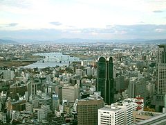
Center of Osaka City

City Hall

Tomb of Emperor Nintoku in Sakai


Web links
- Osaka Tourism and Events Association website (Japanese, English)
Individual evidence
- ↑ Osaka Prefectural Parliament : 議員 情報> 会 派別 一 覧 , accessed August 9, 2019.
- ↑ Osaka Gov. Matsui ready to switch jobs with mayor in double election over metropolis plan (Translation by Mainichi Shimbun, March 4, 2019: [https://mainichi.jp/senkyo/articles/20190304/k00/00m/010/052000c 「入 れ 替 わ り ダ ブ ル 選」へ 松井 ・ 大阪 知事 が 明言 7 日 の 法定 協 見 極 め ]). In: The Mainichi . March 4, 2019, accessed April 1, 2019 .
- ↑ Osaka Ishin, Komeito agree to public vote on Osaka metropolis. In: Asahi Shimbun . May 26, 2019, accessed June 19, 2019 .
- ^ LDP turns around on Osaka metropolis plan, OKs referendum. In: Mainichi Shimbun . June 15, 2019, accessed June 19, 2019 .
- ↑ Kokudo Chiriin : 令 和 元年 全国 都 道 府 県 市区 町 村 別 面積 調 (10 月 1 日 時点) , pp. 40:14 神奈川 県 (Japanese), accessed June 22, 2020.
- ↑ 神奈川 県 の 人口 と 世 帯 - 神奈川 県 ホ ー ム ペ ー ジ . 神奈川 県 , October 1, 2019, accessed October 31, 2019 (Japanese).
- ↑ Kokudo Chiriin (GSI - Geospatial Information Authority of Japan), 平 成 30 年 全国 都 道 府 県 市区 町 村 別 面積 調 (Nationwide Survey of All Prefectures and Municipalities 2018) , p. 66: 27 Osaka-fu (Japanese), accessed on 8 March 2019
- ↑ 簡 単 検 索 ・ 詳細 検 索 ・ 検 索 サ ン プ ル , accessed March 8, 2019 (Japanese)
- ↑ e-stat (English), accessed on March 8, 2019
- ↑ Kokudo Chiriin : 平 成 30 年 全国 都 道 府 県 市区 町 村 別 面積 調 , p. 67 f .: 大阪 府
- ↑ e-Stat database , accessed on March 8, 2019 (English)
- ↑ e-Stat database , accessed on March 8, 2019 (English)
- ↑ Prefecture Police (Japanese, English, Korean, Chinese)
- ↑ Prefectural Public Safety Commission (Japanese)
- ↑ Office of the National Police Department for the Kinki District (Japanese)
- ↑ Ōsaka Prefectural Administration: Education Committee (Japanese, English, Chinese, Korean)
- ↑ Osaka Prefectural Administration , 府 民 文化部 都市 魅力 創造 局 国際 課 都市 外交 グ ル ー プ : 友好 交流 の あ ゆ み ・ 大阪 府 の 友好 交流 都市 (Japanese, English summary )
Aichi | Akita | Aomori | Chiba | Ehime | Fukui | Fukuoka | Fukushima | Gifu | Gunma | Hiroshima | Hokkaidō | Hyōgo | Ibaraki | Ishikawa | Iwate | Kagawa | Kagoshima | Kanagawa | Kochi | Kumamoto | Kyoto | Mie | Miyagi | Miyazaki | Nagano | Nagasaki | Nara | Niigata | Ōita | Okayama | Okinawa | Osaka | Saga | Saitama | Shiga | Shimane | Shizuoka | Tochigi | Tokyo | Tokushima | Tottori | Toyama | Wakayama | Yamagata | Yamaguchi | Yamanashi
Coordinates: 34 ° 40 ' N , 135 ° 32' E