
Saint-Sulpice-et-Cameyrac
| Saint-Sulpice-et-Cameyrac | ||
|---|---|---|
.svg)
|
|
|
| region | Nouvelle-Aquitaine | |
| Department | Gironde | |
| Arrondissement | Bordeaux | |
| Canton | La Presqu'île | |
| Community association | Sector de Saint-Loubès | |
| Coordinates | 44 ° 55 ' N , 0 ° 23' W | |
| height | 3–64 m | |
| surface | 15.04 km 2 | |
| Residents | 4,614 (January 1, 2017) | |
| Population density | 307 inhabitants / km 2 | |
| Post Code | 33450 | |
| INSEE code | 33483 | |
 Mairie Saint-Sulpice-et-Cameyrac |
||

Saint-Sulpice-et-Cameyrac is a French town in the Gironde department in the region Nouvelle-Aquitaine . The municipality is located between the cities of Bordeaux and Libourne. While Saint-Sulpice-et-Cameyrac had 1142 inhabitants in 1962, there are currently 4614 inhabitants (as of January 1, 2017).
The municipality belongs to the canton of La Presqu'île in the Arrondissement of Bordeaux .
Saint-Sulpice-et-Cameyrac is located in the Entre-Deux-Mers wine-growing region .
Population development
| year | 1962 | 1968 | 1975 | 1982 | 1990 | 1999 | 2007 | 2017 |
| Residents | 1142 | 1406 | 1936 | 3215 | 3520 | 3932 | 4235 | 4614 |
| Sources: Cassini and INSEE | ||||||||
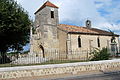
Architectural monuments
- Saint-Jean-Baptiste church
- Saint-Roch church
See also: List of Monuments historiques in Saint-Sulpice-et-Cameyrac

Saint-Jean-Baptiste church
Saint-Roch church


literature
- Le Patrimoine des Communes de la Gironde . Volume 1. Flohic Éditions, Paris 2001, ISBN 2-84234-125-2 , pp. 512-518.
Web links
Commons : Saint-Sulpice-et-Cameyrac - collection of images, videos and audio files