
Westerwald-Steig
| Westerwald-Steig | |
|---|---|
 Waymarks of the Westerwald-Steig |
|
| Data | |
| length | 235 km |
| location | Westerwald |
| Markers | Stylized green W. |
| Starting point |
Herborn 50 ° 40 ′ 59.5 " N , 8 ° 18 ′ 11.6" E |
| Target point |
Bad Hönningen 50 ° 30 ′ 40.4 ″ N , 7 ° 19 ′ 34.5 ″ E |
| Type | Long-distance hiking trail |
| The highest point | Fuchskaute 657.3 m above sea level NHN |
| Level of difficulty | light |
| season | All year round |
| particularities | The path connects the Rothaarsteig with the Rheinsteig . |
The Westerwald-Steig is a 235-kilometer long- distance hiking trail through the Westerwald in Germany .
It was opened on May 24, 2008 by the Rhineland-Palatinate Minister of Economics, Hendrik Hering . His logo and waymark is a stylized green W, symbolizing two rivers flowing into each other in front of green mountains.
course
The climb connects the Rothaarsteig with the Rheinsteig and leads from Herborn an der Dill to Bad Hönningen am Rhein . After starting in Hesse , it goes up into the Hohen Westerwald in Rhineland-Palatinate to Fuchskaute , at 657.3 m above sea level. NHN the highest point in the Westerwald. Continue via Westerburg to the Westerwald Lake District , then via Bad Marienberg and Hachenburg through the Nistertal into Kroppacher Switzerland and finally into the Wiedtal and over the Rheinhöhen to the Rhine.
A total of around 2,800 m ascent and 2,900 m descent are mastered on the way. Only around 20% of the route is asphalted, the rest leads over field, meadow and forest paths.
Attractions
Special sights on the Westerwald-Steig are the high school in Herborn, the karst educational path and the autumn labyrinth in Erdbach , the Holzbach gorge near Gemünden , the Westerwald lake district, the spa gardens in Bad Marienberg, the old market in Hachenburg, the Marienstatt monastery , the Kroppacher Switzerland, the Ehrenstein monastery and the museum experience Roman world at the upper Germanic Limes .
Stages
A suggested hiking route for the Westerwald-Steig includes the following 16 stages.
-
Herborn to Breitscheid (15 km with inclines, about 5 to 6 hours)
Herborn's old town is famous for its well-preserved medieval buildings. In Uckersdorf there is an animal park on the route. Geological and archaeological finds, especially fossils, can be viewed in the Geological Museum Time Jumps in Erdbach . The Breitscheid community has set up a karst educational trail for this purpose. The stalactite cave Herbstlabyrinth is on this stage. - Breitscheid to Fuchskaute (12 km, about 4 hours)
The stage through the Hohen Westerwald leads over the 614 m above sea level. NHN high Bartenstein ( Barstein ) to the Heisterberger Weiher and to the highest mountain in the Westerwald, the Fuchskaute . The mountain rises at 657.3 m above sea level. NHN over a wide basalt plateau that is used as grassland. - Fuchskaute to Rennerod (13 km, 3 to 4 hours)
The climb leads past Homberg over the half-timbered village of Rehe and the Krombachtalsperre nature reserve to Rennerod . - Rennerod to Westerburg (17 km, 4 hours)
The nature reserve Holzbachbruchbruch near Seck is one of the oldest in the Westerwald (since 1929). - Westerburg to Freilingen (20.5 km, approx. 6 hours)
The hiking trail leads through the hilly landscape with tertiary deposits via Rothenbach to Freilingen to the Westerwald lake district around the Dreifelder Weiher . - From Freilingen to the Nistertal (13.5 km, 3.5 hours)
along the lake to Dreifelden with the oldest stone church in the Westerwald. At Linden the source of the Wied is passed. Lochum is widely circumvented in the source basin of Lochumer stream and can be reached through the outskirts of Enspel place Nistertal . Between Nistertal, Enspel and Stockum-Püschen is the tertiary and industrial adventure park Stöffel with a 100-year-old forge. - Nistertal to Bad Marienberg (7 km, 2.5 hours)
From Nistertal it goes past Hardt via Langenbach to the health resort Bad Marienberg . There is a barefoot path as a special kind of hiking experience, a pharmacy garden , a wildlife park with falconry and information on local basalt mining . - Bad Marienberg to Hachenburg (15.5 km, 4.5 hours)
You reach the town of Hachenburg with its castle, market square, hunting museum and open-air museum via Stangenrod and the left slope of the Waschbach stream . - Hachenburg (km 11.5, 3.5 hours) to Limbach
on steps it goes down to the timber stream, over the Nister local Nister over to Nistermühle . Between the monasteries of Marienstatt and Marienthal , take the Marienwanderweg to Streithausen and from there along the Kleiner Nister to Limbach . - Limbach to Marienthal (20.5 km, 5 hours)
You continue on the Marienwanderweg along the small Nister via Astert and Heuzert to Heimborn to the confluence of the small and large Nister, the so-called "German corner of Kroppacher Switzerland ". This natural spectacle is also reflected in the logo of the Westerwald-Steig. From Heimborn it goes via Ehrlich, Steinwingert ( Weltende nature trail ), Racksen through the Altenkirchen state forest to the Marienthal monastery . - Marienthal to Weyerbusch (16 km, 5 hours)
The way to Weyerbusch leads over the 388 meter high Beulskopf with the Raiffeisen Tower with a view of the Siebengebirge , the Bergisches Land and the foothills of the Rothaargebirge . Friedrich Wilhelm Raiffeisen was mayor of Weyerbusch . - Weyerbusch to Flammersfeld (14.5 km, 4 hours)
along the Ersfeld district and the Mehrbachtal ; in Flammersfeld Raiffeisen was mayor office. You can visit a museum in his house. - Flammersfeld to Horhausen (15 km, 4 hours)
From Flammersfeld it goes past Seifen into the Grenzbach valley via Pleckhausen to Horhausen . - Horhausen to Strauscheid (18 km, 5.5 hours)
Via Niedersteinebach it goes to Peterslahr to the Rhine-Westerwald Nature Park in the Neuwied district to Strauscheid, a district of Neustadt (Wied) . - Strauscheid to Waldbreitbach (15.5 km, 5 hours)
Here it goes south over the Weißenfelser Lei and the 340 meter high Roßbacher Häubchen via Roßbach to Waldbreitbach , the crib village . - Waldbreitbach to Bad Hönningen am Rhein (12 km, 4 hours)
First you reach the monastery of the Franciscan Brothers in Hausen and at 373 meters the former basalt quarry Malberg, then over wide forest paths the Limesweg , which you now follow on Roman tracks to Bad Hönningen .
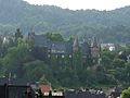
Herborn Castle above the Dill

Westerburg Castle and Castle Church

Bad Marienberg
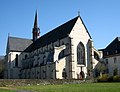
Marienstatt Abbey in Nistertal


See also
literature
- Renate and Olaf Goebel: hiking tours Westerwaldsteig. Idea-Media, Neuwied 2008, ISBN 978-3-934342-53-8 , precise descriptions with stage maps, elevation profiles, important addresses and GPS data.
- Heidrun Braun: Adventure Westerwald-Steig. 235 kilometers of adventure hiking between Herborn and Bad Hönningen. Görres Verlag, Koblenz 2008, ISBN 978-3-935690-64-5 .
- Westerwaldsteig . Land survey office Rhineland-Palatinate 2008, 1: 50000, ISBN 978-3-89637-406-6 .
- Westerwald-Steig . PublicPress Publikationsgesellschaft, Geseke 2008, 1: 25000, ISBN 978-3-89920-461-2 .
- HJ Hucke: A journey of discovery through the culture and hiking region of the Westerwald. Ziethen-Panorama Verlag, 2007, 5th edition, ISBN 978-3-929932-54-6 .
- Sylvia Seligmann: Westerwald-Steig. Conrad Stein Verlag, Welver, ISBN 978-3-86686-250-0 .
Movies
- The W shows the way. Out and about on the Westerwaldsteig. Part 1: From Herborn to Bad Marienberg. Report, Germany, 2008, 30 min., Script and director: Peter J. Klein, production: SWR , series: Fahr mal hin , first broadcast: June 17, 2008, film information from SWR.
- The W shows the way. Out and about on the Westerwaldsteig. Part 2: From Bad Marienberg to the Rhine. Report, Germany, 2008, 30 min., Script and director: Peter J. Klein, production: SWR , series: Fahr mal hin , first broadcast: June 24, 2008, film information from SWR.
Web links
- The website of the Westerwald-Steig
- Official GPS data of the Westerwald-Steig
- More GPS data on the Westerwald-Steig
- Hiking reports and many photos of all Westerwald Steig stages
- Literature on the Westerwald-Steig in the catalog of the German National Library
Individual evidence
- ↑ The Rheinpfalz , "Westerwald-Steig" is officially opened today , May 24th, 2008
- ^ Westerwald-Steig in Wanderatlas Deutschland
- ↑ Wanderkompass.de portal: Westerwald-Steig, hiking fun is green with us. (No longer available online.) Masepo GmbH, archived from the original on July 28, 2008 ; Retrieved June 4, 2008 . Info: The archive link was inserted automatically and has not yet been checked. Please check the original and archive link according to the instructions and then remove this notice.