Écueil
| Écueil | ||
|---|---|---|
|
|
||
| region | Grand Est | |
| Department | Marne | |
| Arrondissement | Reims | |
| Canton | Fismes-Montagne de Reims | |
| Community association | Grand Reims | |
| Coordinates | 49 ° 11 ′ N , 3 ° 57 ′ E | |
| height | 72-236 m | |
| surface | 12.46 km 2 | |
| Residents | 304 (January 1, 2017) | |
| Population density | 24 inhabitants / km 2 | |
| Post Code | 51170 | |
| INSEE code | 51225 | |
| Website | http://www.ecueil.com/ | |
 Town hall ( Mairie ) of Écueil |
||
Écueil is a French commune with 304 inhabitants (as of January 1, 2017) in the Marne department in the Grand Est region (before 2016 Champagne-Ardenne ). The municipality belongs to the Arrondissement of Reims and the canton of Fismes-Montagne de Reims .
geography
Écueil is located about ten kilometers south-southwest of the city center of Reims . Écueil is surrounded by the neighboring communities of Sacy in the north, Bezannes in the northeast, Villers-aux-Nœuds in the east and northeast, Chamery in the south and southeast, Nanteuil-la-Forêt in the south, Pourcy in the southwest and Marfaux in the west and southwest.
Population development
| year | 1962 | 1968 | 1975 | 1982 | 1990 | 1999 | 2006 | 2017 |
| Residents | 304 | 288 | 290 | 300 | 362 | 365 | 323 | 304 |
| Sources: Cassini and INSEE | ||||||||
Attractions
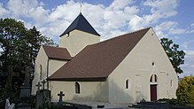
- Saint-Crispin-et-Saint-Crespinien church, Monument historique
Personalities
- Claude Godbillon (1937–1990), mathematician
Web links
Commons : Écueil - collection of images, videos and audio files

