
Arcis-le-Ponsart
| Arcis-le-Ponsart | ||
|---|---|---|
|
||
| region | Grand Est | |
| Department | Marne | |
| Arrondissement | Reims | |
| Canton | Fismes-Montagne de Reims | |
| Community association | Grand Reims | |
| Coordinates | 49 ° 14 ′ N , 3 ° 42 ′ E | |
| height | 100-248 m | |
| surface | 15.43 km 2 | |
| Residents | 313 (January 1, 2017) | |
| Population density | 20 inhabitants / km 2 | |
| Post Code | 51170 | |
| INSEE code | 51014 | |
_1.jpg) City Hall ( Mairie ) of Arcis-le-Ponsart |
||

Arcis-le-Ponsart is a French commune with 313 inhabitants (as of January 1, 2017) in the Marne department in the Grand Est region (before 2016 Champagne-Ardenne ). The municipality belongs to the Arrondissement of Reims and the canton of Fismes-Montagne de Reims (until 2015 the canton of Fismes ).
geography
Arcis-le-Ponsart is about 34 kilometers west of the city center of Reims . Arcis-le-Ponsart is surrounded by the neighboring communities of Monts-sur-Courville in the north, Courville in the north and northeast, Crugny in the east and northeast, Brouillet in the east, Lagery in the southeast, Vézilly in the south, Coulonges-Cohan in the southwest and Dravegny in the West.
Population development
| year | 1962 | 1968 | 1975 | 1982 | 1990 | 1999 | 2006 | 2017 |
| Residents | 341 | 301 | 247 | 231 | 243 | 261 | 268 | 313 |
| Sources: Cassini and INSEE | ||||||||
Attractions
- Notre-Dame church from the 12th century
- Notre-Dame de Igny Monastery, founded in 1128, dissolved in 1790, rebuilt since 1929
- Arcis-le-Ponsart Castle

Notre-Dame church
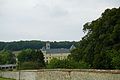
Notre-Dame Convent of Igny


Web links
Commons : Arcis-le-Ponsart - collection of images, videos and audio files