Witry-lès-Reims
|
Witry-lès-Reims Vuytry |
||
|---|---|---|
|
|
||
| region | Grand Est | |
| Department | Marne | |
| Arrondissement | Reims | |
| Canton | Bourgogne | |
| Community association | Grand Reims | |
| Coordinates | 49 ° 18 ' N , 4 ° 7' E | |
| height | 88-186 m | |
| surface | 16.49 km 2 | |
| Residents | 5,020 (January 1, 2017) | |
| Population density | 304 inhabitants / km 2 | |
| Post Code | 51420 | |
| INSEE code | 51662 | |
| Website | http://www.witry-les-reims.fr/ | |
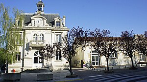
 Witry-lès-Reims town hall |
||
Witry-lès-Reims (on Champenois : Vuytry ) is a French commune with 5020 inhabitants (as of January 1, 2017) in the Marne department in the Grand Est region . It belongs to the Arrondissement of Reims and the Canton of Bourgogne . The inhabitants are called Witryat .
geography
Witry-lès-Reims is located in the Montagne de Reims Regional Nature Park . Witry-lès-Reims is surrounded by the neighboring communities Fresne-lès-Reims in the north, Pomacle in the northeast, Caurel in the east, Berru in the southeast, Cernay-lès-Reims in the south, Reims in the southwest and Bétheny in the west.
The A34 autoroute runs through the municipality .
Population development
| year | 1962 | 1968 | 1975 | 1982 | 1990 | 1999 | 2006 | 2011 |
| Residents | 1,466 | 1,502 | 1,782 | 4,674 | 4,572 | 4,625 | 4,704 | 4,713 |
Attractions
- Saint-Symphorien, whose steeple since 1922 Monument historique is
- Memorial of the First World War
Personalities
- Antonio Abenoza (1926–1953), football player, died near Witry
- Francis Méano (1931–1953), football player, died near Witry
Web links
Commons : Witry-lès-Reims - Collection of images, videos and audio files

