Cormontreuil
| Cormontreuil | ||
|---|---|---|

|
|
|
| region | Grand Est | |
| Department | Marne | |
| Arrondissement | Reims | |
| Canton | Reims-8 | |
| Community association | Grand Reims | |
| Coordinates | 49 ° 13 ' N , 4 ° 3' E | |
| height | 78-146 m | |
| surface | 4.62 km 2 | |
| Residents | 6,524 (January 1, 2017) | |
| Population density | 1,412 inhabitants / km 2 | |
| Post Code | 51350 | |
| INSEE code | 51172 | |
| Website | www.cormontreuil.fr/ | |
 Mairie Cormontreuil |
||
Cormontreuil is a commune in north-eastern France in the Grand Est region and in the Marne department . Cormontreuil belongs to the Reims arrondissement and is part of the canton of Reims-8 (until 2015: canton of Reims-7 ). The inhabitants are called Cormontreuillois (e) .
Geographical location
Cormontreuil is a banlieue in the south of Reims . Cormontreuil is surrounded by the neighboring communities of Reims in the north and west, Taissy in the east and south-east and Trois-Puits in the south.
Autoroute A4 and Autoroute A34 lead through the municipality .
history
The first reports of a place at this point date back to the year 850. The place is mentioned as Curtis Monasteriolis .
| year | 1962 | 1968 | 1975 | 1982 | 1990 | 1999 | 2006 | 2017 |
| Residents | 1343 | 1602 | 3601 | 6080 | 5745 | 6390 | 6238 | 6524 |
Attractions
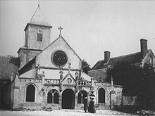
- Saint-André church, founded in 1159
- Château de Cormontreuil
Web links
Commons : Cormontreuil - collection of images, videos and audio files


