
Auménancourt
| Auménancourt | ||
|---|---|---|
|
||
| region | Grand Est | |
| Department | Marne | |
| Arrondissement | Reims | |
| Canton | Bourgogne | |
| Community association | Grand Reims | |
| Coordinates | 49 ° 23 ' N , 4 ° 4' E | |
| height | 61-95 m | |
| surface | 12.82 km 2 | |
| Residents | 1,048 (January 1, 2017) | |
| Population density | 82 inhabitants / km 2 | |
| Post Code | 51110 | |
| INSEE code | 51025 | |
| Website | http:// Bäumenancourt.fr/ | |
 Town Hall (Mairie) of Auménancourt |
||

Auménancourt is a French commune with 1,048 inhabitants (as of January 1, 2017) in the Marne department in the Grand Est region . It belongs to the Arrondissement of Reims and the Canton of Bourgogne .
geography
Auménancourt is located about 13 kilometers north-northeast of Reims on the Suippe . Auménancourt is surrounded by the neighboring communities of Brienne-sur-Aisne in the north, Poilcourt-Sydney in the north-east, Saint-Étienne-sur-Suippe in the east, Bourgogne in the south, Brimont in the south-west, Orainville in the west and south-west and Pignicourt in the west and north-west.
history
In 1967 the present municipality was created through the amalgamation of the places or municipalities Auménancourt-le-Grand , Auménancourt-le-Petite and Pontgivart .
Population development
| year | 1962 | 1968 | 1975 | 1982 | 1990 | 1999 | 2006 | 2012 |
| Residents | 254 | 409 | 522 | 658 | 659 | 696 | 861 | 973 |
| Source: Cassini and INSEE | ||||||||
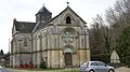
Attractions
- Saint-Firmin church
- Saint-Nicaise church
- Sainte-Félicité church
- medieval bridge

Saint-Firmin church
Sainte-Félicité church

