
Pignicourt
| Pignicourt | ||
|---|---|---|
|
||
| region | Hauts-de-France | |
| Department | Aisne | |
| Arrondissement | Laon | |
| Canton | Guignicourt | |
| Community association | Communauté de communes de la Champagne Picarde | |
| Coordinates | 49 ° 25 ′ N , 4 ° 2 ′ E | |
| height | 55-87 m | |
| surface | 7.01 km 2 | |
| Residents | 197 (January 1, 2017) | |
| Population density | 28 inhabitants / km 2 | |
| Post Code | 02190 | |
| INSEE code | 02601 | |

Pignicourt is a French municipality with 197 inhabitants (as of January 1 2017) in the department of Aisne in the region of Hauts-de-France . It belongs to the Arrondissement of Laon and the Canton of Guignicourt .
location
The municipality is in the Picardy countryside . It borders in the northwest on Villeneuve-sur-Aisne , in the north of Neufchatel-sur-Aisne , in the northeast on Brienne-sur-Aisne , in the southeast on Auménancourt , to the south Orainville , on the southwest by Bertricourt and to the west Variscourt .
Population development
| year | 1962 | 1968 | 1975 | 1982 | 1990 | 1999 | 2008 | 2015 |
|---|---|---|---|---|---|---|---|---|
| Residents | 116 | 115 | 78 | 85 | 96 | 136 | 141 | 196 |
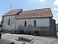
Saint-Rémi church

Mairie Pignicourt

Lock No. 1 in the Aisne Lateral Canal
_%C3%A9glise.JPG)
_mairie.JPG)
_Canal_lat%C3%A9ral_%C3%A0_l%27Aisne,_%C3%A9cluse_nr_1.JPG)
Web links
Commons : Pignicourt - collection of images, videos and audio files