Lappion
| Lappion | ||
|---|---|---|

|
|
|
| region | Hauts-de-France | |
| Department | Aisne | |
| Arrondissement | Laon | |
| Canton | Guignicourt | |
| Community association | Champagne Picarde | |
| Coordinates | 49 ° 36 ′ N , 3 ° 58 ′ E | |
| height | 82-134 m | |
| surface | 23.71 km 2 | |
| Residents | 268 (January 1, 2017) | |
| Population density | 11 inhabitants / km 2 | |
| Post Code | 02150 | |
| INSEE code | 02409 | |
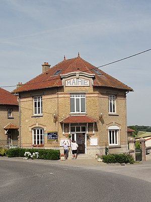
 Town hall (Mairie) of Lappion |
||
Lappion is a French municipality with 268 inhabitants (as of January 1 2017) in the department of Aisne in the region of Hauts-de-France ; it belongs to the arrondissement of Laon and the canton of Guignicourt (until 2015: canton of Sissonne ).
geography
Lappion is about 25 kilometers east-northeast of Laon . Lappion is surrounded by the neighboring communities Boncourt in the north, Dizy-le-Gros in the north-east, Nizy-le-Comte in the east, La Selve in the south and south-east, Sissonne in the south and west and Sainte-Preuve in the west and north-west.
history
Since the late Middle Ages, the Notre-Dame Basilica has been the destination of pilgrimages to the Virgin Mary.
Population development
| year | 1962 | 1968 | 1975 | 1982 | 1990 | 1999 | 2006 | 2013 |
| Residents | 361 | 337 | 266 | 226 | 252 | 292 | 287 | 299 |
| Source: Cassini and INSEE | ||||||||
Attractions
- Saint Germain Church
- Entrance building of the old train station
Web links
Commons : Lappion - collection of images, videos and audio files


