Neuville-sur-Ailette
| Neuville-sur-Ailette | ||
|---|---|---|
|
|
||
| region | Hauts-de-France | |
| Department | Aisne | |
| Arrondissement | Laon | |
| Canton | Guignicourt | |
| Community association | Chemin des Dames | |
| Coordinates | 49 ° 28 ′ N , 3 ° 42 ′ E | |
| height | 77-178 m | |
| surface | 4.45 km 2 | |
| Residents | 105 (January 1, 2017) | |
| Population density | 24 inhabitants / km 2 | |
| Post Code | 02860 | |
| INSEE code | 02550 | |
 Town hall (hôtel de ville) of Neuville-sur-Ailette |
||
Neuville-sur-Ailette is a French municipality with 105 inhabitants (at January 1, 2017) in the department of Aisne in the region of Hauts-de-France (before 2016 Picardy ). It belongs to the arrondissement of Laon and the canton of Guignicourt ( Craonne until 2015 ).
geography
The municipality is located around 12.5 km southeast of the prefecture of Laon and 119 km northeast of the capital Paris . Neuville-sur-Ailette is surrounded to the east and south by the neighboring municipality of Chermizy-Ailles and by the municipalities of Cerny-en-Laonnois in the southwest, Chamouille in the west and Martigny-Courpierre in the north in the canton of Laon-2 .
Population development
| year | 1962 | 1968 | 1975 | 1982 | 1990 | 1999 | 2005 | 2015 |
| Residents | 83 | 79 | 74 | 86 | 71 | 78 | 75 | 102 |
| Source: Cassini and INSEE | ||||||||
Leisure and Tourism
The Domaine du Lac d'Ailette , located on the territory of the communes of Chamouille and Neuville-sur-Ailette, opened in autumn 2007 as the third French Center Parcs . The 84 hectare tourist property is located in a wooded area on the edge of a 140 hectare reservoir. The property has a small marina, artificial beaches and a covered sports and leisure area with an area of 7500 m², on which around 30 different activities are offered.
Attractions
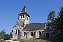
- Saint-Julien church


