
Molinchart
| Molinchart | ||
|---|---|---|
|
||
| region | Hauts-de-France | |
| Department | Aisne | |
| Arrondissement | Laon | |
| Canton | Laon-1 | |
| Community association | Pays de Laon | |
| Coordinates | 49 ° 34 ' N , 3 ° 32' E | |
| height | 70-108 m | |
| surface | 4.47 km 2 | |
| Residents | 329 (January 1, 2017) | |
| Population density | 74 inhabitants / km 2 | |
| Post Code | 02000 | |
| INSEE code | 02489 | |
 Molinchart Town Hall (Mairie) |
||

Molinchart is a French municipality with 329 inhabitants (at January 1, 2017) in the department of Aisne in the region of Hauts-de-France ; it belongs to the arrondissement of Laon and is part of the canton of Laon-1 .
geography
The village is about five kilometers west of Laon . Furthermore, Molinchart is surrounded by the neighboring communities Clacy-et-Thierret in the east and south-east, Laniscourt in the south, Cessières-Suzy in the west, Bucy-lès-Cerny in the north-west and Cerny-lès-Bucy in the north.
Population development
| year | 1962 | 1968 | 1975 | 1982 | 1990 | 1999 | 2005 | 2015 |
| Residents | 234 | 236 | 201 | 223 | 271 | 276 | 286 | 327 |
| Source: Cassini and INSEE | ||||||||
Attractions
- Saint Martin Church
- Hottée de Gargantua, about 10 meters high rock group

Saint Martin Church
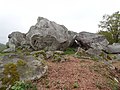
Hottée de Gargantua
_%C3%A9glise.JPG)

Web links
Commons : Molinchart - collection of images, videos and audio files