
Tavaux-et-Pontséricourt
| Tavaux-et-Pontséricourt | ||
|---|---|---|
|
||
| region | Hauts-de-France | |
| Department | Aisne | |
| Arrondissement | Laon | |
| Canton | Marle | |
| Community association | Pays de la Serre | |
| Coordinates | 49 ° 44 ' N , 3 ° 54' E | |
| height | 92-185 m | |
| surface | 25.42 km 2 | |
| Residents | 569 (January 1, 2017) | |
| Population density | 22 inhabitants / km 2 | |
| Post Code | 02250 | |
| INSEE code | 02737 | |

Tavaux-et-Pontséricourt is a French municipality with 569 inhabitants (at January 1, 2017) in the department of Aisne in the region of Hauts-de-France . It belongs to the Laon arrondissement , the Marle canton and the Pays de la Serre municipal association .
geography
Tavaux-et-Pontséricourt is surrounded by the neighboring communities of Agnicourt-et-Séchelles in the east, Montigny-le-Franc in the south, Saint-Pierremont in the south-west, Bosmont-sur-Serre in the north-west and the communes of Burelles in the canton of Vervins in the north-west as well as Braye-en-Thiérache and Vigneux-Hocquet in the northeast.
history
On the morning of August 30, 1944, a dozen resistance fighters attacked young SS soldiers to prevent them from blowing the bridge. Thereupon soldiers of the Leibstandarte SS Adolf Hitler and the 12th SS Panzer Division "Hitler Youth" from Marle and Montcornet cordoned off the village with Tiger tanks , machine guns and troop transports. In the retaliatory act that followed, 20 civilians were murdered and 86 houses destroyed.
Population development
| year | 1962 | 1968 | 1975 | 1982 | 1990 | 1999 | 2009 | 2015 |
| Residents | 797 | 766 | 752 | 666 | 622 | 590 | 594 | 579 |
| Source: Cassini and INSEE | ||||||||
Attractions
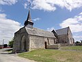
- Notre-Dame fortified church from the 12th century, monument historique since 1989
- Saint-Médard church in Pontséricourt

Notre-Dame church in Tavaux
Saint-Médard church in Pontséricourt
_%C3%A9glise_Notre-Dame_de_Tavaux_(02).JPG)
_%C3%A9glise_de_Ponts%C3%A9ricourt_(01).JPG)
See also
Web links
Individual evidence
- ^ Entry in the Base Mérimée of the Ministry of Culture. Retrieved December 11, 2018 (French).