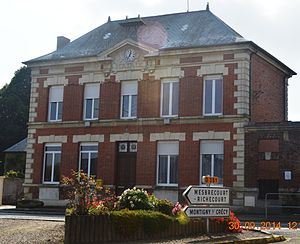
Assis-sur-Serre
| Assis-sur-Serre | ||
|---|---|---|
|
|
||
| region | Hauts-de-France | |
| Department | Aisne | |
| Arrondissement | Laon | |
| Canton | Marle | |
| Community association | Pays de la Serre | |
| Coordinates | 49 ° 41 ′ N , 3 ° 34 ′ E | |
| height | 56-90 m | |
| surface | 8.04 km 2 | |
| Residents | 222 (January 1, 2017) | |
| Population density | 28 inhabitants / km 2 | |
| Post Code | 02270 | |
| INSEE code | 02027 | |
 Town hall (Mairie) of Assis-sur-Serre |
||
Assis-sur-Serre is a French commune with 222 inhabitants (as of January 1, 2017) in the Aisne department of the Hauts-de-France region (until 2015: Picardy ). The municipality belongs to the Laon arrondissement , the Marle canton (until 2015: Crécy-sur-Serre canton ) and the Pays de la Serre municipality .
geography
Assis-sur-Serre is surrounded by the neighboring municipalities of Mesbrecourt-Richecourt in the northwest, Montigny-sur-Crécy in the northeast, Pouilly-sur-Serre in the east, Chéry-lès-Pouilly in the southeast, Couvron-et-Aumencourt in the southwest and Remies in the West. The Serre runs along the northern municipal boundary.
Population development
| year | 1962 | 1968 | 1975 | 1982 | 1990 | 1999 | 2005 | 2015 |
| Residents | 317 | 308 | 291 | 244 | 257 | 266 | 274 | 230 |
| Source: Cassini and INSEE | ||||||||
Attractions
- Saint Martin Church
Web links
Commons : Assis-sur-Serre - Collection of images, videos and audio files

