Folembray
| Folembray | ||
|---|---|---|

|
|
|
| region | Hauts-de-France | |
| Department | Aisne | |
| Arrondissement | Laon | |
| Canton | Vic-sur-Aisne | |
| Community association | Picardy des Châteaux | |
| Coordinates | 49 ° 33 ' N , 3 ° 17' E | |
| height | 49-152 m | |
| surface | 8.85 km 2 | |
| Residents | 1,386 (January 1, 2017) | |
| Population density | 157 inhabitants / km 2 | |
| Post Code | 02670 | |
| INSEE code | 02318 | |
Folembray is a French commune with 1,386 inhabitants (at January 1, 2017) in the department of Aisne in the region of Hauts-de-France ; it belongs to the arrondissement of Laon and the canton of Vic-sur-Aisne .
geography
The community is located above the Ailette valley, about 18 kilometers north of Soissons .
Population development
| year | 1962 | 1968 | 1975 | 1982 | 1990 | 1999 | 2007 | 2016 |
| Residents | 1400 | 1497 | 1368 | 1389 | 1421 | 1490 | 1535 | 1395 |
Attractions
- Saint-Pierre church
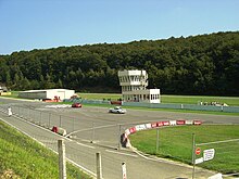
- The Circuit de Folembray , a race track, is located in a wooded area north of the village center .
Web links
Commons : Folembray - collection of images, videos and audio files

