Pancy Courtecon
| Pancy Courtecon | ||
|---|---|---|
|
|
||
| region | Hauts-de-France | |
| Department | Aisne | |
| Arrondissement | Laon | |
| Canton | Guignicourt | |
| Community association | Chemin des Dames | |
| Coordinates | 49 ° 28 ′ N , 3 ° 39 ′ E | |
| height | 70-181 m | |
| surface | 6.37 km 2 | |
| Residents | 56 (January 1, 2017) | |
| Population density | 9 inhabitants / km 2 | |
| Post Code | 02860 | |
| INSEE code | 02583 | |
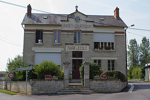
 City Hall (L'hôtel de ville) and Pancy-Courtecon School |
||
Pancy-Courtecon is a French municipality with 56 inhabitants (at January 1, 2017) in the department of Aisne in the region of Hauts-de-France (before 2016: Picardie ). It belongs to the arrondissement of Laon , the canton of Guignicourt (until 2015: canton of Craonne ) and the communal association Chemin des Dames .
geography
The municipality is located around 11 kilometers southeast of the prefecture of Laon and 117 kilometers northeast of the capital Paris . Pancy-Courtecon is surrounded by the neighboring municipalities of Vendresse-Beaulne in the south, Braye-en-Laonnois in the southwest and the municipalities of Colligis-Crandelain in the west, Monthenault in the north, Chamouille in the northeast and Cerny-en-Laonnois in the canton of Laon-2 in the south East.
history
In 1923 the two parishes of Pancy and Courtecon were combined to form today's parish of Pancy-Courtecon.
Population development
| year | 1962 | 1968 | 1975 | 1982 | 1990 | 1999 | 2007 | 2015 |
| Residents | 64 | 67 | 51 | 59 | 56 | 52 | 45 | 60 |
| Source: Cassini and INSEE | ||||||||
Attractions
- Saint-Jean-Baptiste church, built in the 12th century, monument historique since 1921
Web links
Individual evidence
- ^ Entry in the Base Mérimée of the Ministry of Culture. Retrieved December 22, 2018 (French).

