
Évergnicourt
| Évergnicourt | ||
|---|---|---|

|
|
|
| region | Hauts-de-France | |
| Department | Aisne | |
| Arrondissement | Laon | |
| Canton | Guignicourt | |
| Community association | Communauté de communes de la Champagne Picarde | |
| Coordinates | 49 ° 27 ' N , 4 ° 3' E | |
| height | 56-125 m | |
| surface | 9.15 km 2 | |
| Residents | 570 (January 1, 2017) | |
| Population density | 62 inhabitants / km 2 | |
| Post Code | 02190 | |
| INSEE code | 02299 | |
_mairie.JPG) Mairie Évergnicourt |
||

Évergnicourt is a French municipality with 570 inhabitants (as of January 1 2017) in the department of Aisne in the region of Hauts-de-France . It belongs to the Arrondissement of Laon and the Canton of Guignicourt .
location
The municipality is in the Picardy countryside . Neighboring municipalities are Proviseux-et-Plesnoy in the north-west, Avaux in the north-east, Brienne-sur-Aisne in the south-east and Neufchâtel-sur-Aisne in the south-west.
Population development
| year | 1962 | 1968 | 1975 | 1982 | 1990 | 1999 | 2008 | 2015 |
|---|---|---|---|---|---|---|---|---|
| Residents | 591 | 562 | 542 | 541 | 548 | 549 | 548 | 578 |
Attractions
- Saint-Hubert church
- War memorial
economy
- Everbal paper mill
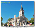
Saint-Hubert church
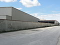
Paper mill
.jpg)
_Papeterie_Everbal_(01).JPG)
Web links
Commons : Évergnicourt - collection of images, videos and audio files