
Crécy-au-Mont
| Crécy-au-Mont | ||
|---|---|---|
.svg)
|
|
|
| region | Hauts-de-France | |
| Department | Aisne | |
| Arrondissement | Laon | |
| Canton | Vic-sur-Aisne | |
| Community association | Communauté de communes Picardie des Châteaux | |
| Coordinates | 49 ° 29 ′ N , 3 ° 20 ′ E | |
| height | 48-160 m | |
| surface | 11.83 km 2 | |
| Residents | 346 (January 1, 2017) | |
| Population density | 29 inhabitants / km 2 | |
| Post Code | 02380 | |
| INSEE code | 02236 | |
 Crécy-au-Mont |
||

Crécy-au-Mont is a French municipality with 346 inhabitants (as of January 1 2017) in the department of Aisne in the region of Hauts-de-France . It belongs to the arrondissement of Laon and the canton of Vic-sur-Aisne .
geography
The municipality is located in the Picardy countryside and borders in the north on Coucy-le-Château-Auffrique , in the north-east on Jumencourt , in the east on Leuilly-sous-Coucy , in the south on Juvigny , in the south-west on Bagneux , in the west on Épagny and im North-west at Pont-Saint-Mard . The border to Coucy-le-Château-Auffrique is formed by the Ailette , which flows through a wooded area there.
Population development
| year | 1962 | 1968 | 1975 | 1982 | 1990 | 1999 | 2008 | 2015 |
|---|---|---|---|---|---|---|---|---|
| Residents | 320 | 295 | 251 | 296 | 294 | 290 | 305 | 345 |
Sights, infrastructure

Bridge over the Oise-Aisne Canal

Saint-Michel church

French military cemetery
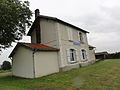
former train station
_canal_de_l%27Oise_%C3%A0_l%27Aisne.JPG)
_%C3%A9glise_(02).JPG)
_necropole_nationale_(01).JPG)
_ancienne_gare_(tramway).JPG)
Web links
Commons : Crécy-au-Mont - Collection of images, videos and audio files