Chéry-lès-Pouilly
| Chéry-lès-Pouilly | ||
|---|---|---|

|
|
|
| region | Hauts-de-France | |
| Department | Aisne | |
| Arrondissement | Laon | |
| Canton | Marle | |
| Community association | Pays de la Serre | |
| Coordinates | 49 ° 39 ′ N , 3 ° 36 ′ E | |
| height | 59-116 m | |
| surface | 17.22 km 2 | |
| Residents | 710 (January 1, 2017) | |
| Population density | 41 inhabitants / km 2 | |
| Post Code | 02000 | |
| INSEE code | 02180 | |
| Website | http://lapagelocale.com/02000-chery-les-pouilly | |
Chéry-lès-Pouilly is a French commune with 710 inhabitants (as of January 1, 2017) in the Aisne department of the Picardy region . The municipality belongs to the arrondissement of Laon and the canton of Marle (until 2015: canton of Crécy-sur-Serre ). The inhabitants are called Chérisiens .
geography
Chéry-lès-Pouilly is about 12 kilometers north of Laon . Chéry-lès-Pouilly is surrounded by the neighboring communities of Pouilly-sur-Serre in the north, Crécy-sur-Serre in the north and north-east, Chalandry in the north-east, Barenton-Cel in the east, Aulnois-sous-Laon in the south and south-east, Vivaise in the Southwest, Couvron-et-Aumencourt to the west and Assis-sur-Serre to the west and northwest.
The A26 autoroute runs through the municipality .
Population development
| year | 1962 | 1968 | 1975 | 1982 | 1990 | 1999 | 2006 | 2013 |
| Residents | 700 | 633 | 605 | 702 | 702 | 645 | 658 | 689 |
| Source: Cassini and INSEE | ||||||||
Attractions
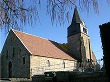
- Saint-Rémi church from the 13th / 14th centuries century

