
Chalandry
| Chalandry | ||
|---|---|---|
|
||
| region | Hauts-de-France | |
| Department | Aisne | |
| Arrondissement | Laon | |
| Canton | Marle | |
| Community association | Pays de la Serre | |
| Coordinates | 49 ° 41 ′ N , 3 ° 39 ′ E | |
| height | 61-135 m | |
| surface | 7.66 km 2 | |
| Residents | 253 (January 1, 2017) | |
| Population density | 33 inhabitants / km 2 | |
| Post Code | 02270 | |
| INSEE code | 02156 | |
 The Souche at Chalandry |
||

Chalandry is a French municipality with 253 inhabitants (at January 1, 2017) in the department of Aisne in the region of Hauts-de-France (before 2016 Picardy ). It belongs to the Laon arrondissement , the canton of Marle (until 2015 Crécy-sur-Serre ) and the Pays de la Serre municipality .
geography
The municipality is located on the Souche , which flows into the Serre after a few kilometers at Crécy-sur-Serre . Chalandry is surrounded by the neighboring communities of Crécy-sur-Serre in the west and northwest, Mortiers in the northeast, Barenton-sur-Serre in the east, Barenton-Cel in the south and Chéry-lès-Pouilly in the southwest.
Population development
| year | 1962 | 1968 | 1975 | 1982 | 1990 | 1999 | 2007 | 2015 |
| Residents | 248 | 240 | 233 | 230 | 225 | 222 | 208 | 247 |
| Source: Cassini and INSEE | ||||||||
Attractions
- Saint-Aubin church
- Chalandry Castle, built in the 16th century, monument historique since 1927
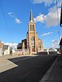
Saint-Aubin church
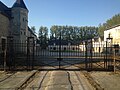
Château de Chalandry


Web links
Commons : Chalandry - collection of images, videos and audio files
Individual evidence
- ^ Entry in the Base Mérimée of the Ministry of Culture. Retrieved December 11, 2018 (French).