
Pontavert
| Pontavert | ||
|---|---|---|
|
||
| region | Hauts-de-France | |
| Department | Aisne | |
| Arrondissement | Laon | |
| Canton | Guignicourt | |
| Community association | Communauté de communes de la Champagne Picarde | |
| Coordinates | 49 ° 24 ' N , 3 ° 49' E | |
| height | 47-120 m | |
| surface | 13.37 km 2 | |
| Residents | 610 (January 1, 2017) | |
| Population density | 46 inhabitants / km 2 | |
| Post Code | 02160 | |
| INSEE code | 02613 | |

Pontavert is a French municipality with 610 inhabitants (as of January 1 2017) in the department of Aisne in the region of Hauts-de-France . It belongs to the Arrondissement of Laon and the Canton of Guignicourt .
location
The municipality is in the Picardy countryside . Neighboring municipalities are Craonne in the northwest, Corbeny in the northeast, La Ville-aux-Bois-lès-Pontavert in the east, Berry-au-Bac and Gernicourt in the southeast, Concevreux in the south, Chaudardes in the southwest and Beaurieux and Craonnelle in the west.
Population development
| year | 1962 | 1968 | 1975 | 1982 | 1990 | 1999 | 2008 | 2015 |
|---|---|---|---|---|---|---|---|---|
| Residents | 299 | 268 | 282 | 296 | 416 | 444 | 605 | 607 |
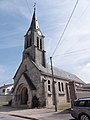
Saint-Médard church

Military cemetery

Town Hall ( Mairie )
_%C3%89glise.JPG)

_Mairie.JPG)
Web links
Commons : Pontavert - collection of images, videos and audio files