Manicamp
| Manicamp | ||
|---|---|---|
|
|
||
| region | Hauts-de-France | |
| Department | Aisne | |
| Arrondissement | Laon | |
| Canton | Vic-sur-Aisne | |
| Community association | Chauny Tergnier la Fère | |
| Coordinates | 49 ° 34 ' N , 3 ° 10' E | |
| height | 38-69 m | |
| surface | 10.24 km 2 | |
| Residents | 307 (January 1, 2017) | |
| Population density | 30 inhabitants / km 2 | |
| Post Code | 02300 | |
| INSEE code | 02456 | |
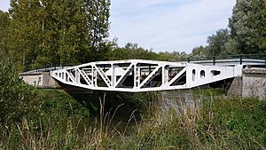
 Bridge over the Oise on the Manicamp-Abbécourt road |
||
Manicamp is a French municipality with 307 inhabitants (at January 1, 2017) in the Aisne department in the region of Hauts-de-France ; it belongs to the arrondissement of Laon and the canton of Vic-sur-Aisne .
geography
The municipality of Manicamp is located roughly halfway between the cities of Laon (37 kilometers away), Saint-Quentin (38 kilometers away) and Compiègne (34 kilometers away). The Oise-Aisne Canal branches off from the Oise , which forms the northern border of the municipality, in the northeasternmost corner of Manicamp .
Neighboring municipalities Manicamps are: Quierzy in the west, Marest-Dampcourt in the northwest, Abbécourt in the north, Bichancourt in the northeast, Saint-Paul-aux-Bois in the southeast, Besmé in the south and Bourguignon-sous-Coucy in the southwest.
Population development
| year | 1962 | 1968 | 1975 | 1982 | 1990 | 1999 | 2008 | 2016 |
| Residents | 371 | 336 | 317 | 313 | 333 | 344 | 310 | 312 |
Attractions
- Church of St. Peter ( Église Saint-Pierre )

