Martigny-Courpierre
| Martigny-Courpierre | ||
|---|---|---|
|
|
||
| region | Hauts-de-France | |
| Department | Aisne | |
| Arrondissement | Laon | |
| Canton | Laon-2 | |
| Community association | Pays de Laon | |
| Coordinates | 49 ° 29 ′ N , 3 ° 41 ′ E | |
| height | 78-196 m | |
| surface | 4.46 km 2 | |
| Residents | 124 (January 1, 2017) | |
| Population density | 28 inhabitants / km 2 | |
| Post Code | 02860 | |
| INSEE code | 02471 | |
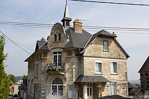
 City Hall (Mairie) and Martigny-Courpierre School |
||
Martigny-Courpierre is a French municipality with 124 inhabitants (at January 1, 2017) in the department of Aisne in the region of Hauts-de-France (before 2016 Picardy ). It belongs to the arrondissement of Laon and the canton of Laon-2 ( Craonne until 2015 ).
geography
Martigny-Courpierre is surrounded by the neighboring communities of Chamouille in the southwest of Bruyères-et-Montbérault in the northwest, Chérêt in the north, Orgeval in the northeast, Bièvres in the southeast and the municipalities of Chermizy-Ailles and Neuville-sur-Ailette in the south in the canton of Guignicourt .
Population development
| year | 1962 | 1968 | 1975 | 1982 | 1990 | 1999 | 2009 | 2015 |
| Residents | 121 | 115 | 105 | 91 | 103 | 122 | 115 | 119 |
| Source: Cassini and INSEE | ||||||||
Attractions
- Saint-Martin church, historic monument since 1910
Web links
Commons : Martigny-Courpierre - collection of images, videos and audio files
