
Chevregny
| Chevregny | ||
|---|---|---|
|
||
| region | Hauts-de-France | |
| Department | Aisne | |
| Arrondissement | Laon | |
| Canton | Guignicourt | |
| Community association | Communauté de communes du Chemin des Dames | |
| Coordinates | 49 ° 28 ′ N , 3 ° 36 ′ E | |
| height | 66-188 m | |
| surface | 8.85 km 2 | |
| Residents | 187 (January 1, 2017) | |
| Population density | 21 inhabitants / km 2 | |
| Post Code | 02000 | |
| INSEE code | 02183 | |

Chevregny is a French municipality with 187 inhabitants (as of January 1 2017) in the department of Aisne in the region of Hauts-de-France . It belongs to the Arrondissement of Laon and the Canton of Guignicourt .
location
The municipality is in the Picardy countryside . It borders in the north with Laval-en-Laonnois , in the northeast with Nouvion-le-Vineux and Lierval , in the east with Trucy , in the southeast with Colligis-Crandelain , in the south with Braye-en-Laonnois , in the southwest with Ostel and in the west to Monampteuil .
Population development
| year | 1962 | 1968 | 1975 | 1982 | 1990 | 1999 | 2008 | 2015 |
|---|---|---|---|---|---|---|---|---|
| Residents | 194 | 176 | 164 | 147 | 178 | 196 | 195 | 192 |
Attractions
- Saint-Médard church
- Chevregny Castle

Saint-Médard church

former castle
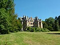
today's castle


Web links
Commons : Chevregny - collection of images, videos and audio files