Craonne
| Craonne | ||
|---|---|---|

|
|
|
| region | Hauts-de-France | |
| Department | Aisne | |
| Arrondissement | Laon | |
| Canton | Guignicourt | |
| Community association | Chemin des Dames | |
| Coordinates | 49 ° 26 ' N , 3 ° 47' E | |
| height | 59-181 m | |
| surface | 8.62 km 2 | |
| Residents | 82 (January 1, 2017) | |
| Population density | 10 inhabitants / km 2 | |
| Post Code | 02160 | |
| INSEE code | 02234 | |
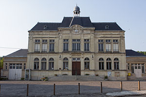
 Town hall (Mairie) of Craonne |
||
Craonne is a French commune in the department of Aisne in the Région Hauts-de-France (2016: Picardie ). It belongs to the arrondissement of Laon , the canton of Guignicourt (until 2015: canton of Craonne ) and the communal association Chemin des Dames . The community has 82 residents (as of January 1, 2017) who are called Craonnais .
geography
Craonne is about 30 kilometers northwest of Reims . Craonne is surrounded by the neighboring communities Bouconville-Vauclair in the north and west, Corbeny in the east and northeast, La Ville-aux-Bois-lès-Pontavert in the southeast, Pontavert in the south and Craonnelle in the south and southwest.
history
During the battles on the Aisne in 1917 and 1918, the municipality of Craonne was part of the parade area.
Population development
| year | 1962 | 1968 | 1975 | 1982 | 1990 | 1999 | 2006 | 2013 |
| Residents | 150 | 140 | 96 | 78 | 68 | 67 | 65 | 77 |
| Source: Cassini and INSEE | ||||||||
Attractions
- Saint-Martin church from 1931
- Town hall from 1926

