
Pont-Saint-Mard
| Pont-Saint-Mard | ||
|---|---|---|
|
||
| region | Hauts-de-France | |
| Department | Aisne | |
| Arrondissement | Laon | |
| Canton | Vic-sur-Aisne | |
| Community association | Communauté de communes Picardie des Châteaux | |
| Coordinates | 49 ° 30 ′ N , 3 ° 17 ′ E | |
| height | 46-158 m | |
| surface | 6.79 km 2 | |
| Residents | 205 (January 1, 2017) | |
| Population density | 30 inhabitants / km 2 | |
| Post Code | 02380 | |
| INSEE code | 02616 | |
_city_limit_sign.JPG) Entrance to Pont-Saint-Mard |
||

Pont-Saint-Mard is a northern commune with 205 inhabitants (as of January 1 2017) in the department of Aisne in the region of Hauts-de-France (2015: Picardie ). It belongs to the Arrondissement Laon , the canton Vic-sur-Aisne (until 2015: canton Coucy-le-Château-Auffrique ) and the communal association Communauté de communes Picardie des Châteaux .
geography
Pont-Saint-Mard is surrounded by the neighboring communities Guny in the west, Champs on a short section in the north, Coucy-le-Château-Auffrique in the northeast, Crécy-au-Mont in the east and Épagny in the south.
history
At the time of the French Revolution , the place was called Pont-sur-Lette .
Population development
| year | 1962 | 1968 | 1975 | 1982 | 1990 | 1999 | 2006 | 2015 |
|---|---|---|---|---|---|---|---|---|
| Residents | 257 | 235 | 220 | 201 | 195 | 179 | 179 | 198 |
| Source: Cassini and INSEE | ||||||||
Attractions
- Saint-Médard church, monument historique since 1919
- Château de Pont-Saint-Mard, Monument historique since 2002

Saint-Médard church
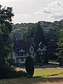
Château de Pont-Saint-Mard
_%C3%A9glise.JPG)

Web links
Commons : Pont-Saint-Mard - Collection of images, videos and audio files
Individual evidence
- ^ Entry in the Base Mérimée of the Ministry of Culture. Retrieved December 22, 2018 (French).
- ^ Entry in the Base Mérimée of the Ministry of Culture. Retrieved December 22, 2018 (French).