Chamery
| Chamery | ||
|---|---|---|
|
|
||
| region | Grand Est | |
| Department | Marne | |
| Arrondissement | Reims | |
| Canton | Fismes-Montagne de Reims | |
| Community association | Grande Reims | |
| Coordinates | 49 ° 10 ′ N , 3 ° 57 ′ E | |
| height | 114-268 m | |
| surface | 5.27 km 2 | |
| Residents | 416 (January 1, 2017) | |
| Population density | 79 inhabitants / km 2 | |
| Post Code | 51500 | |
| INSEE code | 51112 | |
| Website | http://www.chamery.fr/ | |
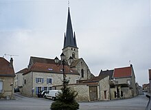
 Town hall ( Mairie ) of Chamery |
||
Chamery is a French commune with 416 inhabitants (as of January 1, 2017) in the Marne department in the Grand Est region (before 2016 Champagne-Ardenne ). The municipality belongs to the Arrondissement of Reims and the canton of Fismes-Montagne de Reims (until 2015 canton of Verzy ). The inhabitants are called chamayots .
geography
Chamery is about 14 kilometers south-southwest of the city center of Reims . Chamery is surrounded by the neighboring communities of Écueil in the north and west, Villers-aux-Nœuds in the northeast, Sermiers in the east and southeast, Courtagnon in the south and Nanteuil-la-Forêt in the southwest.
Population development
| year | 1962 | 1968 | 1975 | 1982 | 1990 | 1999 | 2006 | 2013 |
| Residents | 345 | 362 | 365 | 394 | 383 | 400 | 392 | 393 |
| Source: Cassini and INSEE | ||||||||
Attractions
- Saint-Pierre-et-Saint-Paul church, Monument historique
Web links
Commons : Chamery - collection of pictures, videos and audio files

