Abertamy
| Abertamy | ||||
|---|---|---|---|---|
|
||||
| Basic data | ||||
| State : |
|
|||
| Region : | Karlovarský kraj | |||
| District : | Karlovy Vary | |||
| Area : | 869.6119 ha | |||
| Geographic location : | 50 ° 22 ′ N , 12 ° 49 ′ E | |||
| Height: | 900 m nm | |||
| Residents : | 975 (Jan. 1, 2019) | |||
| Postal code : | 362 35 | |||
| License plate : | K | |||
| structure | ||||
| Status: | city | |||
| Districts: | 2 | |||
| administration | ||||
| Mayor : | Zdeněk Lakatoš (as of 2011) | |||
| Address: | Farní 2 362 35 Abertamy |
|||
| Municipality number: | 554979 | |||
| Website : | www.abertamy.eu | |||
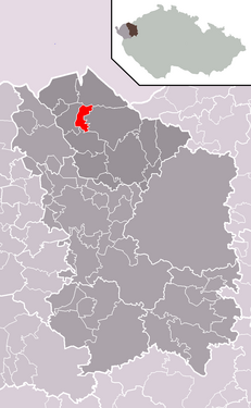
| Location of Abertamy in the Karlovy Vary district | ||||

|
||||
Abertamy ( German Abertham ) is a town in the Karlsbad District in the Karlovy Vary Region in the Czech Republic .
geography
location
The city is located in western Bohemia in the Bohemian Ore Mountains at an altitude of 900 m nm above the valley of the Red Wistritz . To the west of the city is the headwaters of the Fischbach ( Rybná ).
Community structure
The municipality Abertamy consists of the districts Abertamy ( Abertham ) and Hřebečná ( stallion heirs ), which also form cadastral districts.
Neighboring places
| Boží Dar (God's gift) | ||
| Pernink (Bärringen) |

|
Jáchymov (St. Joachimsthal) |
| Merklín (Merkelsgrün) |
history
Abertham was founded in 1529 by Saxon miners recruited by Count Stefan Schlick and received the status of a royal mining town in 1579 . The initially profitable tin and silver deposits in the vicinity of the city were soon exhausted. The plague broke out in 1600 , then the Thirty Years' War caused great destruction. As a result of the Habsburg re-Catholicisation policy , many residents emigrated to Electoral Saxony in the second half of the 17th century. The population lived from a modest house trade (especially lace making).
It was not until 1792 that the town received market rights, and in 1876 it was again elevated to the status of town. From 1850, Abertham developed into the center of Bohemian glove production , with the extensive Chiba family in the lead. But also sheet metal production and artificial flower manufacturers settled here. From 1850 Abertham was a political municipality in the judicial district of Platten and from 1910 part of the Neudek district . In the 1860s the Albrechtsstollen-Silberzeche was closed. The mining of cobalt also played an important role in the history of the city.
With a special postmark showing the silhouette of Abertham and a pair of gloves, the city advertised its “world-famous leather glove industry” in 1939 and in the following years until the end of the war. Since Johann Krakl founded his factory for ice cream gloves in 1892, the manufacture of gloves has already developed into a global flagship for the Bohemian town of Abertham near Karlsbad in what was once Austria-Hungary .
After the First World War , Neudek was added to the newly created Czechoslovakia in 1919 . Due to the Munich Agreement , in which the integration of the Sudetenland into the German Reich was agreed, Abertham belonged from 1938 to 1945 to the district of Neudek , administrative district of Eger , in the Reichsgau Sudetenland .
After the end of the Second World War , Czechoslovakia took over the place; the German-speaking population was then almost completely expropriated and expelled . Czechs from the interior as well as Slovaks and Roma were settled. There is still a small cemetery in the village with German-language gravestones. After 1945, uranium was mined in Abertamy .
Abertamy is now a winter sports center. Many houses that were vacant after the eviction were demolished. A forest school has been located in the town since 1946 , and it was decided to close and merge it with the vocational school center in Nejdek in April 2005. Since June 22nd 2007, Abertamy has again had city rights - for the third time in its history.
Demographics
| year | Residents | Remarks |
|---|---|---|
| 1830 | 1,619 | in 232 houses |
| 1847 | 1,842 | in 233 houses |
| 1869 | 2,046 | |
| 1880 | 2.149 | |
| 1890 | 2,256 | |
| 1900 | 2,610 | (as a municipality 4,004) German residents |
| 1910 | 2,834 | |
| 1921 | 2,404 | |
| 1930 | 2,600 | as a municipality 3,512 inhabitants, including three Czechs and 3484 German inhabitants |
| 1939 | 2,937 |
| year | 1950 | 1961 1 | 1970 1 | 1980 1 | 1991 1 | 2001 1 | 2011 1 |
|---|---|---|---|---|---|---|---|
| Residents | 1,595 | 1,715 | 1,145 | 1,156 | 1,052 | 1,197 | 1,213 |
Attractions
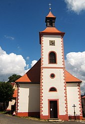
- The most important building in the community is the baroque Church of the Fourteen Holy Helpers from 1738
- In the immediate vicinity of the town rises the 1028 m high Plešivec ( Pleßberg ) with a mountain hotel and observation tower.
- Cross-border Anton-Günther-Weg
- Mine pit Mauritius in the district Hřebečná (stallion heirs)
- Tin museum in the neighboring Horní Blatná
Personalities
Honorary citizen
2004: Ehrenfried Zenker (1934–2016), b. in Abertham, earned merits in maintaining and renovating the church
sons and daughters of the town
- Elias Richter (1597–1678), schoolmaster in Platten, pastor in Raschau
- Peter Kuhn (1628–1682), mountain and shift foreman, owner of paint mills in plates
- Theophil Richter (1636–1699), schoolmaster and mountain master in early penance
- Josef Henrich (1879–1943), forester in Vorarlberg
- Franziska Böhm (* 1937), dialect author
People related to the place
- Gregor Richter (archdeacon) (1563–1633), pastor in Abertham
- Josef Schütz (1910–1989), mayor
Trivia
- A specialty is the goat cheese with herbs ( Abertam ) named after the place .
literature
- Joachim Bahlcke , Winfried Eberhard, Miloslav Polívka (eds.): Bohemia and Moravia (= Kröner's pocket edition. Vol. 329). 1998, ISBN 3-520-32901-8 .
Web links
Individual evidence
- ↑ http://www.uir.cz/obec/554979/Abertamy
- ↑ Český statistický úřad - The population of the Czech municipalities as of January 1, 2019 (PDF; 7.4 MiB)
- ↑ http://www.uir.cz/casti-obce-obec/554979/Obec-Abertamy
- ↑ http://www.uir.cz/katastralni-uzemi-obec/554979/Obec-Abertamy
- ^ Stamp database, accessed on March 4, 2015
- ↑ Abertham. In: Meyers Großes Konversations-Lexikon. Volume 1: A to Astigmatism. 6th, completely revised and enlarged edition, new impression. Bibliographisches Institut, Leipzig et al. 1905, p. 30, column 2 .
- ↑ Yearbooks of the Bohemian Museum of Natural and Regional Studies, History, Art and Literature . Volume 2, Prague 1831, p. 200, point 2).
- ↑ Johann Gottfried Sommer : The Kingdom of Bohemia . Volume 15: Elbogner Kreis , Prague 1847, p. 79, item 1).
- ^ Meyer's Large Conversational Lexicon . 6th edition, Volume 14, Leipzig and Vienna 1908, p. 542 .
- ^ A b Michael Rademacher: German administrative history from the unification of the empire in 1871 to the reunification in 1990. Neudek district. (Online material for the dissertation, Osnabrück 2006). , 2006.
- ^ Sudetenland Genealogy Network
- ↑ Historický lexikon obcí České republiky - 1869-2015. (PDF) Český statistický úřad, December 18, 2015, accessed on January 21, 2016 (Czech).


