
Bachtelmühle
|
Bachtelmühle
City of Kempten (Allgäu)
Coordinates: 47 ° 43 ′ 21 ″ N , 10 ° 20 ′ 27 ″ E
|
||
|---|---|---|
| Height : | 700 m above sea level NN | |
| Residents : | 14 (May 25 1987) | |
| Postal code : | 87437 | |
| Area code : | 0831 | |
Location of Bachtelmühle in Kempten (Allgäu) |
||

Bachtelmühle is a wasteland in the independent city of Kempten (Allgäu) . The district is located on the Bachtelbach , which leaves the Bachtelweiher (Dolderweiher) around 550 meters above (east) . The Bachtelmühle belonged to the rural community of Sankt Mang until 1972 , with which it was incorporated into the city of Kempten. "Bachtel" is said to have developed from the word "Bachtal". The brook used to be called Tiefenbach or historically "Tuffinbach".
According to the last census on May 25, 1987, the Bachtelmühle had a population of 14 in two buildings with living space and five apartments. Müller's large German local register from 2012 only gives seven residents.
history
The Bachtelmühle was first mentioned in 1293 with "Cuonrat der Muller vf dem Tuffinbach". In the same year, the Kempten monastery sold the mill to St. Gallen because of unsuccessful ventures. In 1440 the monastery again acquired the "Mühlstatt im Bachthal" along with other goods from an Albrecht Rist. Since then, the Bachtelmühle has been a penal grinder. In 1740, when the land was exchanged between the prince monastery and an heir, it was noted that the mill was being rebuilt. This building, which was rebuilt in 1934 and after 1970, is a listed building .
In 1793 the house was called "Eggenmühle". This name can probably be traced back to the owner at the time. On the historical field map from the 19th century, the field name "Eggens fields" is entered north of the mill . This area is now part of a mini golf course.
In 1819 the Bachtelmühle consisted of an estate with four residents. The mill belonged to the main Lenzfried team .
The pond used by the monastery for carp breeding also belonged to the property. A bathing establishment was set up by the pond in 1951.

The district of Bachtelmühle
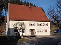
Listed residential building


Web links
Individual evidence
- ↑ Official directory for Bavaria, territorial status: May 25, 1987, Munich, 1991 , p. 385
- ↑ Müller's Großes Deutsches Ortsbuch, 2012, page 84
- ^ Peter Blickle: Historical Atlas of Bavaria: Kempten. Munich 1968 , p. 52
- ↑ Historical land map in the BayernAtlas
- ^ A b Heinrich Uhlig: Sankt Mang. History of an Allgäu community. Verlag des Heimatpflegers von Schwaben, Kempten (Allgäu) 1955, p. 362.
- ^ Peter Blickle: Historical Atlas of Bavaria: Kempten. Munich 1968 , p. 362 (there Bachtlmühle )

Adelharz | Ajen | Ashes | Atzenried | Brooks | Bachtelmühle | Bachtelsteig | Track wood | Chunk | Bezachmühle | Binzenried | Birch trees | Buck species | Borstadels | Widths | Bremberg | Bucharts | Bühl | Bühls | Burkarts | Dolders | Dorns | Dottenried | Trinity | Harrows | Calibration | Ellatsberg | Ellharten | Elmatried | Eppenried | Figs | Felben | Greinats | Grub | Hafenthal | Heaps | Hardening nail | Härtnagel am Mariaberg | Hasenbühl | Haslach | Hassberg | Haubensteig | Holy Cross | Hinterbach | Hinteregg | Backwood | Hinterrottach | Hirschdorf | Hochstraß | Courtier | Hohenrad | Hub | Hunter's | Johannisried | Barren | Kaurus | Kempten | Kindo | Blades | Knee bos | Kollerbach | Kornangers | Lamblings | Lauben orBruck | Lauben udBruck | Leinschwenden | Lenzfried | Latvians | Leubas | Leupolz | Leupratsried | Lochbruck | Lotterberg | Lugemanns | Mariaberg | Mayrhof | Mollenmühle | Moss | Moosers | Motzen | Mühlbach | Neuhausen | Oberbühl | Obergrünenberg | Oberheggers | Oberried | Oberschmieden | Oberwang | Oberwies | Oberwittleiters | Unconscious | Öschberg | Prestlings | Rappenschuchen | Roughing | Reichselsberg | Reinharts | Reisachmühle | Reiters | Ried | Riederau | Ringlers | Skirt courtiers | Sedge | Rothkreuz | Rottach | Rottachmühle | Saint Mang | Shadow | Schlatt | Chatter | Schwabelsberg | Blacks | Seeangers | Segger | Seibrees | Summer | Stadtallmey | City pond | Storage roof | Staudach b. Mariaberg | Climb | Steinberg | Star blades | Sighs | Stiftallmey | Pen bleach | Sticks | Stockers | Stoffels | Stölzling | Striker | Tannach | Fir trees | Thingers | Unterbühl | Untergrünenberg | Unterheggers | Unterried | Forging | Unterwang | Instructed | Unterwittleiters | Ursulasried | Voglsang | Vorderhalden | Vorderwaldmanns | Path stains | Weidach | Weidachsmühle | Pond | Wettmannsberg | Wies | Customs house | To Rottach