Châtenay (Saône-et-Loire)
| Châtenay | ||
|---|---|---|
|
|
||
| region | Bourgogne-Franche-Comté | |
| Department | Saône-et-Loire | |
| Arrondissement | Charolles | |
| Canton | Chauffailles | |
| Community association | La Clayette Chauffailles en Brionnais | |
| Coordinates | 46 ° 18 ' N , 4 ° 23' E | |
| height | 384-600 m | |
| surface | 8.07 km 2 | |
| Residents | 165 (January 1, 2017) | |
| Population density | 20 inhabitants / km 2 | |
| Post Code | 71800 | |
| INSEE code | 71116 | |
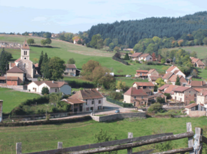
 View of Châtenay |
||
Châtenay is a French municipality with 165 inhabitants (as of January 1 2017) in Saône-et-Loire in the region of Bourgogne Franche-Comté . It belongs to the Arrondissement Charolles and the community association La Clayette Chauffailles en Brionnais, founded in 2016 . The inhabitants are called Châtenoyons .
geography
Châtenay is located about 50 kilometers west of Mâcon in the hills of Brionnais and Charolais . Neighboring municipalities of Châtenay are Gibles in the north, Aigueperse in the east, Saint-Racho in the south and Varennes-sous-Dun in the west.
Population development
| year | 1962 | 1968 | 1975 | 1982 | 1990 | 1999 | 2006 | 2011 | 2016 |
| Residents | 258 | 260 | 229 | 214 | 184 | 166 | 166 | 161 | 163 |
| Source: Cassini and INSEE | |||||||||
Attractions
- Saint-Joseph church from 1877
- museum
supporting documents
Web links
Commons : Châtenay - collection of images, videos and audio files

