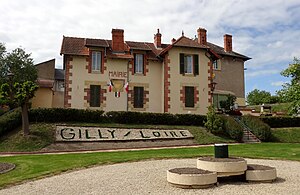
Gilly-sur-Loire
| Gilly-sur-Loire | ||
|---|---|---|
|
|
||
| region | Bourgogne-Franche-Comté | |
| Department | Saône-et-Loire | |
| Arrondissement | Charolles | |
| Canton | Digoin | |
| Community association | Entre Arroux, Loire et Somme | |
| Coordinates | 46 ° 32 ' N , 3 ° 47' E | |
| height | 207-311 m | |
| surface | 22.63 km 2 | |
| Residents | 487 (January 1, 2017) | |
| Population density | 22 inhabitants / km 2 | |
| Post Code | 71160 | |
| INSEE code | 71220 | |
 Town hall (Mairie) of Gilly-sur-Loire |
||
Gilly-sur-Loire is a French commune with 487 inhabitants (at January 1, 2017) in the department of Saone-et-Loire in the region of Bourgogne Franche-Comté (before 2016 Bourgogne ). The municipality belongs to the arrondissement Charolles and the canton Digoin (until 2015 Bourbon-Lancy ). The inhabitants are called the Gillysois .
geography
Gilly-sur-Loire lies on the Loire . Gilly-sur-Loire is surrounded by the neighboring communities of Saint-Aubin-sur-Loire and Bourbon-Lancy in the north, Chalmoux in the northeast, Perrigny-sur-Loire in the east, Pierrefitte-sur-Loire in the south and southeast and Diou in the south and West.
Population development
| year | 1962 | 1968 | 1975 | 1982 | 1990 | 1999 | 2006 | 2011 | 2016 |
|---|---|---|---|---|---|---|---|---|---|
| Residents | 633 | 648 | 658 | 546 | 546 | 538 | 493 | 487 | 495 |
| Source: Cassini and INSEE | |||||||||
Culture and sights
- Church of Sainte-Anne
Web links
Commons : Gilly-sur-Loire - Collection of images, videos and audio files

