Le Rousset-Marizy
| Le Rousset-Marizy | ||
|---|---|---|
|
|
||
| region | Bourgogne-Franche-Comté | |
| Department | Saône-et-Loire | |
| Arrondissement | Charolles | |
| Canton | Charolles | |
| Community association | Grand Charolais | |
| Coordinates | 46 ° 34 ′ N , 4 ° 25 ′ E | |
| height | 265-486 m | |
| surface | 55.49 km 2 | |
| Residents | 653 (January 1, 2017) | |
| Population density | 12 inhabitants / km 2 | |
| Post Code | 71220 | |
| INSEE code | 71279 | |
Le Rousset-Marizy is a French municipality with 653 inhabitants (as of January 1 2017) in Saône-et-Loire in the region of Bourgogne Franche-Comté . It belongs to the Arrondissement Charolles , the canton Charolles (until 2015: canton La Guiche ) and the communal association Communauté de communes Le Grand Charolais .
geography
Le Rousset-Marizy is located about 40 kilometers west-southwest of Chalon-sur-Saône on the Arconce . Le Rousset-Marizy is surrounded by the neighboring communities of Pouilloux in the north and north-west, Saint-Romain-sous-Gourdon and Gourdon in the north, Mary in the north-east, Saint-Marcelin-de-Cray in the east, Chevagny-sur-Guye in the south-east, La Guiche in the south, Ballore in the southwest and Martigny-le-Comte in the west.
history
Le Rousset-Marizy was formed on January 1, 2016 from the previously independent municipalities of Marizy and Le Rousset .
structure
| District | former INSEE code |
Area (km²) | Population (2016) |
|---|---|---|---|
| Marizy (administrative headquarters) | 71279 | 30.75 | 434 |
| Le Rousset | 71375 | 24.74 | 237 |
Attractions
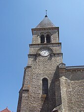
- Church of Sainte-Marie-Marguerite in Marizy
- Saint-Quentin Chapel in Le Rousset
Web links
Individual evidence
- ↑ Population figures retrospectively from January 1, 2016

