Charolles
| Charolles | ||
|---|---|---|

|
|
|
| region | Bourgogne-Franche-Comté | |
| Department | Saône-et-Loire | |
| Arrondissement | Charolles | |
| Canton | Charolles (main town) | |
| Community association | Grand Charolais | |
| Coordinates | 46 ° 26 ' N , 4 ° 17' E | |
| height | 272-355 m | |
| surface | 19.98 km 2 | |
| Residents | 2,785 (January 1, 2017) | |
| Population density | 139 inhabitants / km 2 | |
| Post Code | 71120 | |
| INSEE code | 71106 | |
Charolles is a French commune with 2,785 inhabitants (at January 1, 2017) in Saône-et-Loire in the region of Bourgogne Franche-Comté . It is the administrative seat of the Arrondissement Charolles and the canton of Charolles .

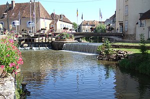
The Arconce in Charolles
geography
Charolles is traversed by the Arconce river and is located at the confluence of its tributary Semence .
The city is located 12 km east of Paray-le-Monial , 15 km south of Palinges , 50 km west of Mâcon and 20 km north of La Clayette . The nearest metropolis is Lyon , around 100 km away.
history
Etymologically, Charolais comes from the Celtic Kadrigel , fortress in the water. Charolles has been the capital of the County of Charolais (or Charollais ) since the area was separated from the County of Chalon-sur-Saône .
Population development
Population development
| year | 1962 | 1968 | 1975 | 1982 | 1990 | 1999 | 2015 |
| Residents | 3,204 | 3.813 | 3,858 | 3,392 | 3,048 | 3,027 | 2,759 |
Attractions
- Charolles Castle , former castle of the Counts of Charolais, of which only a few parts have survived.
- The house of the lords of La Magdeleine: facade (15th century)
- The Catholic Sacred Heart Church
Personalities
- Marc Antoine Baudot (1765–1837), revolutionary
- Jean-François Bayard (1796-1853), playwright
- Guillaume Des Autels (1529 – ≈1580), poet and Romanist
- Louis Jacolliot (1837–1890), consul, author and Indologist
- Charles the Bold (1433–1477), member of the Valois-Burgundy dynasty
- Jean Rémond (1922–2009), Auxiliary Bishop of the Mission de France
- Michel Roux Sr. OBE (1941-2020), cook
- Marie-Antoinette Tonnelat (1912–1980), theoretical physicist
Web links
Commons : Charolles - collection of images, videos and audio files
Wikisource: Charroles in the Topographia Circuli Burgundici (Mathäus Merian) - sources and full texts
