
Jagstzell
| coat of arms | Germany map | |
|---|---|---|

|
Coordinates: 49 ° 2 ' N , 10 ° 6' E |
|
| Basic data | ||
| State : | Baden-Württemberg | |
| Administrative region : | Stuttgart | |
| County : | Ostalbkreis | |
| Height : | 424 m above sea level NHN | |
| Area : | 37.97 km 2 | |
| Residents: | 2319 (December 31, 2018) | |
| Population density : | 61 inhabitants per km 2 | |
| Postcodes : | 73489, 74579, 74597 | |
| Area code : | 07967 | |
| License plate : | AA, GD | |
| Community key : | 08 1 36 035 | |
| Address of the municipal administration: |
Hauptstrasse 6 73489 Jagstzell |
|
| Website : | ||
| Mayor : | Raimund Müller | |
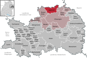
| Location of the municipality of Jagstzell in the Ostalb district | ||
  |
||

Jagstzell is a municipality in Baden-Württemberg and belongs to the Ostalb district .
geography
Geographical location
Jagstzell is located in the natural area of the Swabian-Franconian Forest Mountains in the wooded landscape of the Virngrund on both sides of the Jagst . The community area is between 409 and 516 m above sea level. NN.
Neighboring communities
The community borders in the north on Frankenhardt , Stimpfach and Fichtenau , all of which belong to the Schwäbisch Hall district . In the east lies Ellenberg , in the south the city of Ellwangen and in the west Rosenberg .
Community structure

The Jagstzell community includes the village of Jagstzell, the hamlets of Dankoltsweiler, Dietrichsweiler, Eichenrain, Finkenberg, Grünberg, Hegenberg, Kellerhof, Riegelhof, Riegersheim, Ropfershof, Rot, Rothof, Schweighausen, Spielegert and Winterberg, the Buchmühle, Bühlhof, Kreuthof, Ratzensägmühle and Rennecker Mühle (Renneckermühle) and the houses Dankoltsweiler Sägmühle, Eulenmühle, Finkenhaus, Hahnenmühle, Hegenstadt, Keuerstadt, Neumühle, Orrot, Rotbachsägmühle and Walser (Haus Walser) as well as the abandoned villages of Zem Higgelnberg, Buchberg, Holrödelin, Rentzenrödelinze, Nydemrödelinze old Vischbach, zem Hetzel, Herdern, Wissenbach, Elprisperg, Kippenhof, Gebhart, zem Awevaeter, Widelstet, Hinder Hegneberg, Retichswiler, Gossoltzwiler, Segmül to Danckoltzwyler and Segmül to the Kyrstat. The 30 localities are also districts of the municipality. Their official designation takes place by prefixing the name of the municipality and followed by the name of the districts separated by a hyphen.
Division of space

According to data from the State Statistical Office , as of 2014.
history
Jagstzell was probably founded by monks from the Ellwangen monastery as a small monastic settlement (cella) during the Carolingian era . Around 1150 the monastery was converted into a women's monastery that existed for about 200 years. Not much has been passed down from the history of the monastery; it was first mentioned in a document in 1170 . After the dissolution of the women's monastery, the village came to the prince provost of Ellwangen . Since the beginning of the 16th century, Brandenburg-Ansbach and thus later Prussia had rights in Jagstzell. The Ellwang part became part of Württemberg in 1802 , the Prussian part came to Bavaria in 1806 and finally to Württemberg in 1810. Jagstzell initially belonged to the Oberamt Ellwangen , from 1938 to the Aalen district , which became part of the new Ostalb district as a result of the district reform in 1973 .
Population development
The population figures from 1852 to 1970 are census results and from 1980 official updates of the State Statistical Office (only main residences ).
|
|
religion
In Jagstzell, both denominations are represented today with the Roman Catholic St. Vitus Church and the Protestant Christ Church of the Rechenberg parish . In the Middle Ages, the parish of Jagstzell belonged to the diocese of Würzburg , while the parts of the Ellwang territory further south belonged to the diocese of Augsburg .
politics
Administrative community
The community is a member of the agreed administrative community of the city of Ellwangen.
Municipal council
Raimund Müller has been mayor since 1997. Wilfried Herrmann had previously been mayor since 1973, succeeding Otto Lechner.
The 2014 , 2009 , 2004 and 1999 local elections produced the following results:
| Parties and constituencies |
% 2014 |
Seats 2014 |
% 2009 |
Seats 2009 |
% 2004 |
Seats 2004 |
% 1999 |
Seats 1999 |
|
| FWG | Free community of voters | 66.9 | 8th | 54.5 | 7th | 48.0 | 6th | 46.0 | 5 |
| CDU | Christian Democratic Union of Germany | 33.1 | 4th | 45.5 | 5 | 52.0 | 6th | 54.0 | 7th |
| total | 100.0 | 12 | 100.0 | 12 | 100.0 | 12 | 100.0 | 12 | |
| voter turnout | 61.4% | 64.2% | 66.2% | ||||||
Attractions
Buildings

The Catholic parish church of St. Vitus was built in 1498 in the late Gothic style and redesigned in Baroque style in 1747 . The St. Barbara Chapel from the 14th century is in the Dankoltsweiler district. It has a beautiful late Gothic reticulated vault in the choir . The Romanesque Chapel of St. Nicholas in Keuerstadt was built in 1280 . It is very lonely in the large forest area between Dankoltsweiler and Ellenberg . The "Matzenbacher Bild" chapel is located in the Jagstzell area, near the neighboring village of Matzenbach (municipality of Fichtenau ). It was completed in 1973.
Lakes
In the early 1960s, the Fischbach and Orrot reservoirs were created to protect against flooding . These small lakes are now quite popular as a destination for walks and swimming.
Economy and Infrastructure
traffic


Jagstzell has a train station on the Upper Jagstbahn between Aalen (or Goldshöfe ) and Crailsheim . During the day, regional trains run in both directions every two hours .
As part of the economic stimulus package II , the platforms on both tracks were completely renovated in summer 2010 and brought to a length of 120 m. Bus shelters, signage and other platform equipment have been adapted to the corporate identity of Deutsche Bahn.
The most important road connection is the federal road 290 ( Tauberbischofsheim - Aalen ), which runs through the village in a north-south direction. The federal motorway 7 touches the municipality in the east, its closest junctions are in the north Dinkelsbühl / Fichtenau and in the south Ellwangen .
education
There is a primary school in Jagstzell . Until 2011 the school was also a secondary school with a Werkrealschule , since then secondary school students from Jagstzell have attended schools in Rosenberg or Ellwangen . Secondary schools are located in Ellwangen, Aalen and Crailsheim .
Sons and daughters of the church
- Aloys Wagner (1771–1837), vicar general of Neuwuerttemberg and cathedral chapter in Ellwangen
- Kuno Bux (born October 9, 1928, died January 31, 2014 in Jagstzell), President of the Baden-Württemberg State Criminal Police Office from 1971 to 1988
Web links
Individual evidence
- ↑ State Statistical Office Baden-Württemberg - Population by nationality and gender on December 31, 2018 (CSV file) ( help on this ).
- ↑ Natural areas of Baden-Württemberg . State Institute for the Environment, Measurements and Nature Conservation Baden-Württemberg, Stuttgart 2009
- ^ The state of Baden-Württemberg. Official description by district and municipality. Volume IV: Stuttgart district, Franconian and East Württemberg regional associations. Kohlhammer, Stuttgart 1980, ISBN 3-17-005708-1 . Pp. 726-728
- ^ Jagstzell municipality: main statute of December 9, 2013 .
- ↑ State Statistical Office, area since 1988 according to actual use for Jagstzell.
- ↑ census results on Leo-BW
- ↑ P. Suso Mayer OSB: The parishes of the Ellwangen Abbey in Ellwangen 764–1964 . Schwabenverlag Ellwangen, 1964, pp. 179-224.
- ↑ Final results of the 2014 municipal council elections with comparative information from 2009. Jagstzell municipality (Ostalbkreis). Statistical State Office of Baden-Württemberg , 2014, accessed on April 16, 2018 .
- ↑ Final results of the municipal council elections 2009 with comparative data from 2004. Jagstzell municipality (Ostalbkreis). Baden-Württemberg State Statistical Office , 2010, archived from the original on September 13, 2012 ; Retrieved August 28, 2011 .
- ↑ Jagstzell primary school

Basking | Abtsgmünd | Adelmannsfelden | Bartholomä | Böbingen an der Rems | Bopfingen | Durlangen | Ellenberg | Ellwangen (Jagst) | Eschach | Essingen | Göggingen | Gschwend | Heubach | Hypocrites | Hüttlingen | Iggingen | Jagstzell | Kirchheim am Ries | Lauchheim | Leinzell | Lorch | Mögglingen | Mutlangen | Neresheim | Newbie | Obergröningen | Oberkochen | Rainau | Riesbürg | Rosenberg | Ruppertshofen | Schechingen | Schwäbisch Gmünd | Spraitbach | Stödtlen | Panel red | Tannhausen | Unterschneidheim | Waldstetten | Westhausen | Words