
Dorchheim
|
Dorchheim
municipality Elbe Valley
Coordinates: 50 ° 30 ′ 18 ″ N , 8 ° 3 ′ 47 ″ E
|
|
|---|---|
| Height : | 222 (175–305) m above sea level NHN |
| Area : | 2.35 km² |
| Residents : | 630 (December 31, 2019) |
| Population density : | 268 inhabitants / km² |
| Incorporation : | 1st February 1971 |
| Postal code : | 65627 |
| Area code : | 06436 |
 Aerial view from the east
|
|
Dorchheim is a district of the Elbtal municipality in the Limburg-Weilburg district in Central Hesse . The place is on the southern edge of the Westerwald and is the seat of the municipal administration. Dorchheim has about 630 inhabitants and is a local sub-center for the Elbe Valley community.
geography
Dorchheim is located in the southern Westerwald, about 14 kilometers north of Limburg an der Lahn , 14 kilometers west of Weilburg and 9 kilometers southeast of Westerburg . The place is located in Hesse and is about 3 kilometers from the border with Rhineland-Palatinate .
The neighboring towns are, starting from the north in a clockwise direction: Elbgrund (municipality of Elbtal), Hausen , Ellar (both municipality of Waldbrunn (Westerwald) ), Hangenmeilingen , Heuchelheim (municipality of Elbtal) and Frickhofen (municipality of Dornburg ).
The place is located on the Steinbach , which is still called Lasterbach above the place . The Steinbach flows into the Elbbach in the district of Dorchheim . The Elbbach is located in the district at about 195 m above sea level. NN The highest point of the district is at about 305 m above sea level. NN on the slope of the Mühlhölzchen between Dorchheim and Hausen.
history
The place lies in a probably pre-Germanic settlement area. An artifact was found near Ellar in 1996, which is assigned to the Neolithic . Finds of the Dornburg and the Heidenhäuschen are known that prove a Celtic settlement during the La Tène period . At Hangenmeilingen there are grave mound fields from the Iron Age around 475 BC. Chr.
Dorchheim belongs to a group from ‑heim locations in the Limburg Basin and in the Elbbachtal. These were probably created as a Merovingian imperial property during the early Frankish conquest in the 6th century. The location on an old trade route that came from the north via Rennerod , Irmtraut and Dorchheim to Limburg is probably also of importance for the establishment . The first clear documentary mention was made in 1215 in a document from Abbot Albert of Laach Abbey . With a "Ruker von Dorchheim" a resident lower noble family is also mentioned for the first time. With some uncertainty, a Lenfried who was guaranteed in 1206 can already be assigned to this family.
middle Ages

The village belonged to the original parish Bleseberg with the main town of Frickhofen. There was also the seat of the competent central court , which was subordinate to the district court St. Maximinus and later Office Ellar . The church tithe was owned by the Westerburg rulership and is likely to come from the bailiwick of Gemünden Abbey .
Individual farms in Dorchheim were owned by the Walpoden von Waldmannshausen . A branch of this family was called Meleven von Dorchheim and existed from 1342 to 1394. The property fell by inheritance in 1472 to the ponds of Neunkirchen and the von Liebenstein family .
In 1272 a Kuno von Weilburg, called "von Dorchheim", gave the Abbey of Marienstatt various rights in Dorchheim. The abbey set up a winery in the following period and acquired other properties as planned. In the Dorchheim district alone, the property comprised over 200 acres of land. The abbey also obtained church patronage over the St. Nicholas Chapel.
Dorchheim originally belonged to the County of Diez , but was pledged as part of the Ellar court from 1337 to 1360 to the House of Merenberg and later to the Counts of Nassau-Hadamar . The aristocratic family "von Dorchheim", which continued from Ruker via Kuno, can be documented for the last time in 1366. In 1367 the County of Diez ceded the office of Ellar as a dowry to County Katzenelnbogen . After the end of the dispute over the succession of the County of Nassau-Hadamar, the house of Nassau-Dillenburg received a third on July 28, 1408 , the rest remained with the County of Katzenelnbogen.
With the extinction of the Counts of Katzenelnbogen, there was a long-lasting dispute between the Counts of Nassau-Dillenburg and the Landgraviate of Hesse . The landgraves took possession of the Katzenelnbogen inheritance. The Hessian landgraves temporarily sold half of their stake to Kurtrier in 1534 . The “Frankfurt Treaty” led to a settlement in the Katzenelnbogen succession dispute in 1555. The Ellar office, and thus Dorchheim, belonged entirely to Nassau-Dillenburg since then.
House Nassau (Ottonian Line)
The Reformation began in the county of Nassau-Dillenburg in 1536 . The Counts of Dillenburg prescribed the Lutheran faith. Around 1557, the sovereign Johann VI. from Nassau-Dillenburg to Calvinism , which led to another change of religion.
However, since the patronage of the chapel lay with the Abbey of Marienstatt, it remained Catholic for the time being. The Counts of Dillenburg confiscated the archive of the Abbey in Dorchheim. Father Petrus, who wanted to prevent this, was sentenced to death in Dillenburg in 1567. The situation came to a head when in 1579 the cellar Father Haich converted to the Protestant faith and celebrated a splendid wedding in the “Marienstätter Hof”. The abbey now tried, with the support of the Counts von Sayn, to fill the cellar position with Father Stahl. Father Haich was able to stay in office with the support of the Counts of Nassau-Dillenburg. The winery and the chapel patronage had finally come under Dillenburg control.
When the Nassau-Dillenburg estate was divided in 1607, the Ellar office was assigned to the newly founded county of Nassau-Hadamar under Count Johann Ludwig .
With the beginning of the Thirty Years War in 1618 a devastating phase began for the place. The various warring parties had to be billeted almost every year, and the population also had to pay considerable special taxes and raise bribes. The cause of the war burden was the proximity to the important Lahn crossings and the initial neutrality of the county of Nassau-Hadamar, which meant that no warring party spared the area. Jakob Hoben from Dorchheim joined the league troops before 1630 . The Oran-Nassau rulers remained in possession of their lands despite the edict of restitution after Johann Ludwig converted to Catholicism in Vienna in 1630 . The Jesuits were commissioned to carry out the re-Catholicization in his county .
In 1644, Thebus Keullen , who was praying for health, from Dorchheim was apprehended and punished.
After the extinction of the House of Nassau-Hadamar in 1711, the principality was divided several times between the other Ottonian lines of the House of Nassau. Dorchheim fell to the House of Nassau-Dillenburg in 1717, from 1739 to House Nassau-Diez, 1742/43 to the House of Nassau-Siegen (Catholic), and again Nassau-Diez ( Orange- Nassau) as the last Ottonian line in 1743 .
In 1736 the farmers from Dorchheim took part in the "lace dispute", an uprising against the sovereign in Dillenburg. The cause was the war tax that Prince Christian von Nassau-Dillenburg had imposed on the villages. The farmers chased the seizure officers out of the villages. About 1,600 farmers gathered for an army camp at the Seeweiher Mengerskirchen . The peasants brought the Franciscan Cornelius from Hadamar as field preacher. The peasants had brought cattle and movable property to other rulers across the nearby borders. There were occasional clashes between the farmers and soldiers from Dillenburg and soldiers from Weilburg who had rushed to reinforce them. At the same time, the farmers called the Reich Chamber of Commerce . On June 13, 1736, however, the court confirmed Prince Christian von Nassau-Dillenburg's rights and sentenced the farmers to a fine. Prince Christian von Nassau-Dillenburg had to ask the Prince of Nassau-Weilburg for help to enforce the sentence.
The peddling began in the early 18th century . The trade routes stretched from the Rhineland to Saxony and Switzerland . Pottery, linen and clothing were mainly traded. From 1730 the authorities tried to steer this trade in an orderly manner with the “shopkeeping rules for the parishes of Frickhofen and Lahr”.
Modern times

From 1782 the construction of the new Chaussee / "Neue Mainzer Landstrasse" (today's B 54 ) began, which led to a considerable change in the local traffic routes. The important trunk road from Mainz via Limburg to Siegen now ran through Dorchheim. This led the Orange-Nassau government to consider upgrading the place to a central location . At that time the place consisted of 40 houses.
In 1789, one of the two fire extinguishers was stationed in the combined office of Ellar-Mengerskirchen in Dorchheim, while the other was in Mengerskirchen. A year later the office of Ellar was restored. Since the official building in Ellar was inadequate, the government had a new building built in Dorchheim. The new office building, today's name Alter Amtshof, was completed 1804–1812, but was never used as an office building due to the turmoil of the coalition wars and has been privately owned by the Schmidt family since 2007.
During the coalition wars, troops marched and billeted again from 1792 onwards. In 1795, French troops looted the places in Amt Ellar, including Dorchheim. According to a list by the bailiff Creutzer from 1795 to 1800 the damage incurred in Dorchheim amounted to 28,458 guilders 5 Albus . On November 21, 1810, two people from Dorchheim were doing French military service.
When the Marienstatt Abbey was abolished, the winery in the “Marienstätter Hof” was secularized in 1803 and converted into a manorial domain .

In 1806 Dorchheim was incorporated into the Grand Duchy of Berg . The place belonged to the Mairie Frickhofen in the Canton Hadamar . This belongs to the arrondissement of Dillenburg and thus to the department of Sieg . During the affiliation to the Grand Duchy of Berg, numerous new legal systems came into being. The ban on thatched roofs in 1810 had the greatest impact on the townscape. This regulation should prevent the fire from spreading to other buildings in the event of a fire. The introduction of chimney sweeps also served as fire protection. With the school reform in the Grand Duchy of Berg in 1810, the school was handed over to the civil parish and a year-round school was set up. On September 13, 1811, the mill ban was lifted.
After the defeat of Napoléon Bonaparte in the Battle of the Nations near Leipzig , the Orange-Nassau sovereignty was temporarily restored. The House of Orange-Nassau exchanged its property in the Westerwald with the Kingdom of Prussia for Luxembourg at the Congress of Vienna . The Kingdom of Prussia handed over the territory to the Duchy of Nassau on the same day . When the offices in the Duchy of Nassau were restructured in 1816, Dorchheim was added to the Hadamar office.
In 1843 the village consisted of 63 houses. In October 1848 the German Revolution reached the Westerwald. After initial tumult and tax refusals, open resistance broke out when the military tried to seize the taxes. On February 5, 1849, there were extensive riots in the Hadamar office, in which citizens from Dorchheim probably also took part. When the tithe was replaced in Nassau at Christmas 1848, there was a noticeable improvement in economic conditions.
After the annexation of the Duchy of Nassau in October 1866, Dorchheim again belonged to the Kingdom of Prussia. There it belonged to the province of Hessen-Nassau and the administrative district of Wiesbaden . In 1866, the Prussian district and provincial order abolished the Nassau office. The place belonged to the Oberlahnkreis and from 1886 to the newly founded Limburg district .
In 1882/83 a permanent post office was set up in Dorchheim. On November 1, 1896, the place was raised to an independent parish vicarie, which was converted into a parish on October 1, 1944.

During the First World War , 12 residents died in combat operations or were reported missing. During the Second World War , 14 residents were killed and nine residents were reported missing.
In 1945 the place was assigned to the US-American zone of occupation and thus became part of Hesse. The place belonged to the administrative district Wiesbaden . When it was dissolved in 1968, it became part of the Darmstadt administrative district and in 1981 it became part of the Gießen administrative district . In 1974 the place became part of the newly created district of Limburg-Weilburg .
Dorchheim, Hangenmeilingen and Heuchelheim merged on February 1, 1971 as part of the regional reform in Hesse to form the new Elbe Valley municipality. On July 1, 1973, the place Elbgrund, consisting of the former districts of Waldmannshausen and Mühlbach, joined the community.
Territorial history and administration
The following list gives an overview of the territories in which Dorchheim was located and the administrative units to which it was subordinate:
- In the early and high Middle Ages: rule of Ellar . In the early and high Middle Ages, the Ellar rule consisted of the Zenten Lahr, Elsoff (Westerwaldkreis, Rhineland-Palatinate), Niederzeuzheim and Frickhofen (Bleseberg), which is why the rule was also referred to as the "Four Tenth".
- until 1367: Holy Roman Empire , County Diez (1337–1405 as pledge to County Hadamar )
- 1367–1405: Holy Roman Empire, as part of the "Four Tenth" County Katzenelnbogen
- 1405–1479: Holy Roman Empire, "Four Tithes" (1/3 owned by Nassau-Dillenburg and 2/3 owned by the County of Katzenelnbogen)
- 1479–1534: Holy Roman Empire, "Four Tithes" (2/3 of the Landgraviate of Hesse and 1/3 of the Counts of Nassau-Dillenburg )
- 1534–1557: Holy Roman Empire, "Four Tenth" (Landgraviate of Hesse, the Counts of Nassau-Dillenburg and Kurtrier each 1/3)
- 1557–1606: Holy Roman Empire, County Sayn , "Four Tithes"
- 1606–1650: Holy Roman Empire, Nassau-Hadamar County , "Four Tithes"
- 1650–1711: Holy Roman Empire, Principality of Nassau-Hadamar , Mengerskirchen Office
- 1717–1743: Holy Roman Empire, Principality of Nassau-Dillenburg , Mengerskirchen Office
- 1743–1806: Holy Roman Empire, Counts of Nassau-Diez as part of the Principality of Nassau-Orange , Amt Mengerskirchen
- 1806–1813: Grand Duchy of Berg , Department of Sieg , Canton Hadamar
- 1813–1815: Principality of Nassau-Orange , Mengerskirchen Office
- from 1816: German Confederation , Duchy of Nassau , Hadamar Office
- from 1849: German Confederation, Duchy of Nassau, Hadamar District Office
- from 1854: German Confederation, Duchy of Nassau, Hadamar Office
- from 1867: North German Confederation , Kingdom of Prussia , Province of Hessen-Nassau , Administrative Region of Wiesbaden , Oberlahnkreis
- from 1871: German Empire , Kingdom of Prussia, Province of Hessen-Nassau, administrative district of Wiesbaden, Oberlahnkreis
- from 1886: German Empire, Kingdom of Prussia, Province of Hesse-Nassau, District of Wiesbaden, District of Limburg
- from 1918: German Empire, Free State of Prussia , Province of Hesse-Nassau, District of Wiesbaden, District of Limburg
- from 1944: German Empire, Free State of Prussia, Nassau Province , Limburg District
- from 1945: American zone of occupation , Greater Hesse , Wiesbaden district, Limburg district
- from 1949: Federal Republic of Germany , State of Hesse , Wiesbaden district, Limburg district
- from 1968: Federal Republic of Germany, State of Hesse, administrative district Darmstadt , district Limburg
- on February 1, 1971 Dorchheim was incorporated as a district of the newly formed Elbtal municipality.
- from 1974: Federal Republic of Germany, State of Hesse, administrative district Darmstadt, district Limburg-Weilburg
- from 1981: Federal Republic of Germany, State of Hesse, Gießen district, Limburg-Weilburg district
population
Population development
Until 1624 the number of inhabitants of Dorchheim was recorded together with Mühlbach and Waldmannshausen, so that no individual values are available.
Source: Historical local dictionary
| • 1679: | 21 families |
| Dorchheim: Population from 1834 to 1991 | ||||
|---|---|---|---|---|
| year | Residents | |||
| 1834 | 345 | |||
| 1840 | 405 | |||
| 1846 | 440 | |||
| 1852 | 464 | |||
| 1858 | 450 | |||
| 1864 | 448 | |||
| 1871 | 442 | |||
| 1875 | 496 | |||
| 1885 | 423 | |||
| 1895 | 418 | |||
| 1905 | 425 | |||
| 1910 | 412 | |||
| 1925 | 408 | |||
| 1939 | 428 | |||
| 1946 | 467 | |||
| 1950 | 567 | |||
| 1956 | 588 | |||
| 1961 | 570 | |||
| 1967 | 608 | |||
| 1970 | 613 | |||
| 1987 | 578 | |||
| 1991 | 735 | |||
| Data source: Historical municipality register for Hesse: The population of the municipalities from 1834 to 1967. Wiesbaden: Hessisches Statistisches Landesamt, 1968. Other sources: | ||||
Religious affiliation
Source: Historical local dictionary
| • 1885: | 10 Protestant (= 2.36%), 413 Catholic (= 97.64%) residents |
| • 1961: | 51 Protestant (= 8.95%), 514 Catholic (= 90.18%) residents |
Religions
The predominant denomination and the only place of worship in town are Roman Catholic . The parish “St. Nikolaus ”belongs to the pastoral area Blasiusberg of the Limburg diocese .
politics

For elections to the German Bundestag, the place belongs to the constituency “ Rheingau-Taunus - Limburg ” (179), for elections to the Hessian state parliament it belongs to the constituency “ Limburg-Weilburg I ” (21).
With the territorial reform, the municipal administration was transferred to the Elbtal municipality. There are no local councils in the Elbtal community. Dorchheim has remained the seat of the municipal administration.
Culture and sights
societies
At the local level there is the Elbtal fishing club 1999, the volunteer fire brigade (founded in 1895, including the youth fire brigade since April 27, 2000), the pigeon breeding club "Hui Wäller", the wind orchestra "Elbtal-Musikanten", the Formula 1 club Elbtal, the dart club "DC Shashlik ”and the Catholic women's community in Dorchheim.
Regular events
The most important local festival is the fair, which takes place two weeks before Pentecost .
Buildings
Half-timbered buildings from the 16th to 19th centuries have been preserved in the town center. These are partly single houses typical of the Westerwald and partly three-sided farms . Some of these buildings are plastered or faced.
Old church “St. Nicholas"

The old Catholic Church “St. Nicholas ”now serves as a cemetery chapel. This is a Romanesque building from the 12th century. It was formerly a two-aisled basilica .
The aisle on the north side was demolished at the beginning of the 16th century. At the same time as this change and the new walling of the north wall, ogival windows were added in the south wall and the main nave was provided with a beamed ceiling. The west gallery with its late Gothic design could also come from this renovation campaign, the south pore can be dated to 1702.
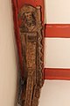
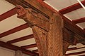
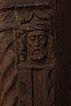
The roof turret was added at an unknown point in time, the timber-framed building elevation dates from the 17th or 18th century. The atmospheric late Gothic design with elaborate carvings (dragons, grimaces, saints' heads) and the 15th century wall paintings in the chancel are considered to be significant in terms of art history. The paintings particularly depict the Last Judgment , as well as passion scenes and scenes from legends of saints. The baroque pulpit was made in 1734.
The memorial also includes around ten historical gravestones and an older part of the cemetery wall.
The building has seen several restoration campaigns: in 1960/61 the wall paintings were exposed. A concrete floor was possibly installed at this point in time or at a later date, but this negatively influenced the water balance of the masonry in the following years and led to damage to the murals. In a renewed restoration campaign after 2000, this change was reversed.
- Construction details of the Nikolauskapelle


Parish Church “St. Nicholas"


After founding the independent parish vicarie, the congregation planned to rebuild the Catholic church “St. Nikolaus ”on an open area outside of the local situation at the time, but close to the Marienstätter Hof. The comparatively simple neo-Gothic building was built in 1905/06. It is a three-aisled basilica with a transept and west tower. The broad transept with the free-standing crossing pillars creates a voluminous, almost square central space. From the interior, the baroque statue of Our Lady of the 18th century is worth mentioning.
The rectory by the church was built around the same time. Part of the memorial is also a small memorial for the victims of both world wars in front of the church.
Marienstatter Hof

The Marienstätter Hof is the former winery of the Marienstatt Abbey , which had owned goods in Dorchheim since the 14th century. The core of the building is believed to date from the early 17th century. However, it was significantly rebuilt in 1702. In particular, today's roof and the large spiral staircase with a turned spindle inside come from this renovation phase. A room door should also come from this time. The entrance door is dated to 1731/32.
It is a two-storey building with a high, two-storey hipped roof . At the northeast corner there is a pentagonal tower with a tail hood. Above the massive ground floor is the upper floor in half-timbered construction , which is characterized in particular by a parapet with St. Andrew's crosses .
After 1803 the building served as a school, council and bakery. Today it houses the municipal administration. Address: Rathausstrasse 1.
Elbbach Bridge

This bridge was built around 1900 to the southwest of the locality to enable the newly built country road towards Frickhofen to cross over the Elbbach. It is a wide-span construction with two flat segment arcs. The masonry is made of very irregularly worked rubble stones. The river pillar and the two land piers have bow reinforcements made of Lahn marble . The historic railing is no longer there.
Switching station

It is one of the few historically valuable energy supply buildings in the region and one of the youngest architectural monuments in the area. Between 1930 and 1935 the switching station was built near the road towards Frickhofen. It shows elements of the New Objectivity , such as the narrow, high window slots and the use of cable entrances and air slots to design the facade. At the same time, the hipped roof and the overall cubature, which is based on a residential building, attempt to adapt to the regional building tradition.
Borngasse 1

This half-timbered house from around 1700 is highlighted by its location on the corner of the former main street, today's Dorfstraße. The three-zone half-timbered structure on the upper floor is dominated by its man forms made of wide wood. In addition, the historical window sizes are still partially preserved.
Brunnenstrasse 1


The half-timbered upper floor of this building clearly shows the expansion of the original two-zone construction of the 18th century in the 19th century. The older part of the building has comparatively richly decorated half-timbering with nested S-struts, man forms and profile carvings on the thresholds. A Franconian bay window that was presumably present at the time was removed. The 19th century extension shows a much simpler framework. The door frame apparently also comes from this expansion period. There is also half-timbered construction under the slate cladding of the gable facing Brunnenstrasse. The monument protection also extends over the adjoining, simple half-timbered barn.
Brunnenstrasse 2
This barn from the 16th or 17th century was one of the oldest surviving half-timbered buildings in the town. The very simple, irregular framework had wood connections with overlapping as well as tenons, which indicates numerous changes and repairs. The building was demolished around the year 2000.
Dorfstrasse 8

The half-timbered structure of this building from the 18th century has artful elements in the older part of the building with nested S-struts, carved corner posts, man shapes and medallions, which in their design language indicate the earlier use by a baker. A narrow extension zone on the back is much simpler. On the street front, changes to the framework have taken place, especially in the later installation of large window openings.
As in the neighboring house at number 16, the half-timbered structure was hidden under artificial slate shortly after the middle of the 20th century until around the year 2000.
Dorfstrasse 16


It is the remainder of a half-timbered house, the other half of which was replaced by the new building at Dorfstrasse 18. In the 20th century, the building was heavily modified and, like the neighboring house with number 8, completely clad with artificial slate, so that the monument value was hardly recognizable.
Around the year 2000, however, the half-timbering was exposed again on the side facing the street and restored. A very uniform half-timbering with square compartments can be seen, but at the same time with rich decoration: man forms on the corner of the building, sun ornaments and above all the approach of a Franconian bay window with richly carved pillars and cornices, but above all with a plaque that points to the builder. The striking quarry stone base was also exposed again.
Amtshof
The Amtshof, built in 1804, is located on Limburger Strasse (B 54). It is a classicist three-wing complex with irregular side wings , which is open to the street. With its formal language, the exposed natural stone masonry and the hipped roof, this complex stands out among the typical structures of the region. The facade is characterized by flat risalits on the back and a surrounding ledge at the level of the ground floor ceiling. Address: Limburger Straße 15
It is the administrative seat of the then Amt Ellar, built between 1804 and 1806, in the county of Orange-Nassau. Since this structure was dismantled in 1816, the building cannot have served its original purpose for long. It came shortly after the privately owned office was dissolved.
Waldmannshäuser Strasse 10

The two-story house, built around 1900, is one of the brick buildings that are not very common in the region. The base made of quarry stone, walls made of sandstone and a frieze at the level crossing adorn the facade. The entrance door is in the Biedermeier style and is shielded by a glass roof with ornamental wrought iron consoles. The associated barn is also part of the monument.
Forest chapel at the Elbmühle farm

The chapel southwest of the village overlooks the Elbbachtal from the edge of a field plateau. The small structure was built from rubble stones around 1905. External architectural decorations are the round arches on the doors and windows as well as a small bell tower on the gable roof.
Economy and Infrastructure
Dorchheim is the seat of Musicgarden Werbe GmbH , a company of ZYX Music GmbH & Co. KG. In addition, there are the local craft and service companies. Most of the employed commute to Limburg and the Rhine-Main area .
The place has a village community center . The Dorchheim volunteer fire brigade founded in 1895 (with its youth fire brigade since April 27, 2000 ) provides defensive fire protection and general help.
traffic
The federal road 54 runs through the village from Limburg an der Lahn to Siegen . The place has no train station. The next rail connection is in Frickhofen to the Oberwesterwaldbahn . There are regular bus routes to Hadamar and Limburg an der Lahn. The distance to Frankfurt Airport is around 80 km.
Dorchheim is close to the Hessian R8 cycle path .
education
There is a Catholic kindergarten in Dorchheim. The place has a central primary school for the entire Elbe Valley community. There are no secondary schools in the community.
literature
- Hellmuth Gensicke : State history of the Westerwald . 3. Edition. Historical Commission for Nassau, Wiesbaden 1999, ISBN 3-922244-80-7 .
- Christian Heger: Village history in the Westerwald. The example of Dorchheim. In: Ders .: W äller Platt. History, grammar and vocabulary of the Westerwald dialect . Husum Druck- und Verlagsgesellschaft, Husum 2016, ISBN 978-3-89876-813-9 , pp. 112-120.
- Alexander Horn: The Marienstätter Hof in Dorchheim . In: District Home Office of the Limburg-Weilburg District (Ed.): Yearbook 1996 . Rekom-Verlag, Wetzlar 1995, p. 94-99 .
- Hermann-Josef Hucke (Ed.): Great Westerwaldführer . 3. Edition. Verlag Westerwald-Verein eV, Montabaur 1991, ISBN 3-921548-04-7 .
- Falko Lehmann: Cultural monuments in the Hesse district Limburg-Weilburg . Ed .: State Office for Monument Preservation Hessen. tape 1 : Mengerskirchen to Weinbach. Friedr. Vieweg & Sohn, Braunschweig / Wiesbaden 1994, ISBN 3-528-06243-6 .
- Karl Hermann May: Kuno von Weilburg called von Dorchheim (1272). In: Nassauische Annalen , 83rd Volume, Wiesbaden 1972, pp. 15-22.
- Peter Pick: From the history of the Elbe Valley villages. Chronicle of the Elbtal community with the districts of Dorchheim, Elbgrund, Hangenmeilingen and Heuchelheim in the Westerwald . Dorchheim 1991.
- Paul Reichwein: Dorchheim in the 20th century. Way of life in the small Westerwalddorf . Dorchheim 2000.
- Walter Rudersdorf: In the shadow of Ellar Castle . Ed .: Municipality of Ellar / Westerwald. Waldemar Kramer, Frankfurt am Main 1967.
- Walter Rudersdorf: Waldbrunn / Westerwald - From farming village to climatic health resort . Ed .: Community of Waldbrunn Westerwald. 1st edition. Geiger-Verlag, Horb 1986, ISBN 3-89264-015-7 .
- Literature about Dorchheim in the Hessian Bibliography
Web links
- District Dorchheim. In: Internet presence. Elbe Valley community
- Dorchheim, Limburg-Weilburg district. Historical local dictionary for Hessen. In: Landesgeschichtliches Informationssystem Hessen (LAGIS).
Individual evidence
- ↑ Population figures in the Elbe Valley . In: Internet presence. Elbtal municipality, accessed on May 4, 2020 .
- ^ Walter Rudersdorf: From the museum, sensational find from the Neolithic Age , in Waldbrunner Nachrichten 7/14/97 page 14
- ^ Walter Rudersdorf: Historical Calendar 1997 -I- in Waldbrunner Nachrichten 24/48/97, p. 24
- ↑ Walter Rudersdorf: In the shadow of Ellar Castle 1967
- ^ Walter Rudersdorf: From the Chronicle of Fussingen - Episode 45 in Waldbrunner Nachrichten 25/50/97, p. 18
- ^ Armin M. Kuhnigk: The 1848 Revolution in the Province . 2nd Edition. Camberger Verlag Lange, Camberg 1980, ISBN 3-87460-028-9 .
- ^ Klaus Schatz: History of the Diocese of Limburg . Society for Middle Rhine Church History, Mainz 1983.
- ↑ According to the list at the memorial
- ^ Municipal reform: mergers and integration of municipalities from January 20, 1971 . In: The Hessian Minister of the Interior (ed.): State Gazette for the State of Hesse. 1971 No. 6 , p. 248 , para. 14 ( online at the information system of the Hessian state parliament [PDF; 6.2 MB ]).
- ^ Federal Statistical Office (ed.): Historical municipality directory for the Federal Republic of Germany. Name, border and key number changes in municipalities, counties and administrative districts from May 27, 1970 to December 31, 1982 . W. Kohlhammer GmbH, Stuttgart and Mainz 1983, ISBN 3-17-003263-1 , p. 369 .
- ↑ a b c d Dorchheim, Limburg-Weilburg district. Historical local dictionary for Hessen. (As of May 24, 2018). In: Landesgeschichtliches Informationssystem Hessen (LAGIS).
- ^ Michael Rademacher: German administrative history from the unification of the empire in 1871 to the reunification in 1990. State of Hesse. (Online material for the dissertation, Osnabrück 2006).
- ↑ Main statutes of the Elbtal community from September 29, 2001
- ↑ Musikverein Elbtal-Musikanten e. V. Accessed June 30, 2015 .
- ↑ updraft on the dart board | Nassau New Press. Retrieved June 30, 2015 .
.png)