Garonne
| Garonne | ||
|
The main rivers in France, including the Garonne |
||
| Data | ||
| Water code | FR : O --- 0000 | |
| location | Southwest France , Spain | |
| River system | Garonne | |
| Drain over | Gironde → Atlantic Ocean | |
| source | in the Val d'Aran in the Catalan Pyrenees 42 ° 37 ′ 4 ″ N , 0 ° 58 ′ 8 ″ E |
|
| Source height | 1872 m | |
| Confluence with the Dordogne to the Gironde (estuary) | Bec d'Ambès north of Bordeaux Coordinates: 45 ° 2 ′ 19 ″ N , 0 ° 36 ′ 40 ″ W 45 ° 2 ′ 19 ″ N , 0 ° 36 ′ 40 ″ W |
|
| Mouth height | 3 m | |
| Height difference | 1869 m | |
| Bottom slope | 2.9 ‰ | |
| length | 647 km | |
| Catchment area | 55,000 km² | |
| Outflow at Le Mas-d'Agenais gauge |
MQ |
631 m³ / s |
| Reservoirs flowed through | Retenue de Labriolette , Retenue du Mancies | |
| Big cities | Toulouse , Bordeaux | |
| Medium-sized cities | Muret , Agen | |
| Navigable | to Castets-en Dorthe ; above the parallel Canal latéral à la Garonne to Toulouse | |
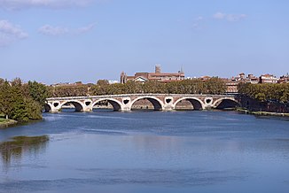
The Garonne [ gaˈʁɔn ] ( Latin Garumna or Garunna , Aranese / Catalan Garona ) is a river in southwest France . In ancient times, it demarcated Aquitaine from the rest of Gaul and forms the northern border of the historic landscape of Gascony .
The 647 km long river originates on the barren plateau "Plan de Beret" north of the Val d'Aran in the Catalan Pyrenees , crossed after a few kilometers, the French border and flows through Toulouse to Bordeaux , where it meets the Dordogne to the estuary Gironde united flows into the Atlantic . The name is derived from the Celtic tribe of the Garumner .
Crossed administrative areas
- Downstream sequence -
Spain, Autonomous Region of Catalonia :
- Province of Lleida , comarca Val d'Aran
France, Occitania region :
France, Nouvelle-Aquitaine region :

Places on the river
- Downriver order - big cities in bold , medium-sized cities in italics -
- Vielha e Mijaran
- Saint-Béat
- Saint-Gaudens
- Cazères
- Carbonne
- Muret
- Portet-sur-Garonne
- Toulouse
- Grenade
- Verdun-sur-Garonne
- Castelsarrasin
- Valence
- Agen
- Tonneins
- Marmande
- Langon
- Bordeaux
River system


Explanations for the table:
- If in a line the indication of the confluence side (“right” / “left”) has been moved under the name box of a line above, the body of water shown in the bottom line flows into the one shown in the above line.
- If a tributary of a higher ranking river is listed in the line under an inflow of a tributary, the associated page number is accordingly further up under the beginning of the name box of the higher-ranking river.
| Garonne, tributaries and their main tributaries, upstream order | |||||||
|---|---|---|---|---|---|---|---|
| Mouth in the direction of flow seen from |
Surname | SANDRE No. | Length [km] |
Catchment area [km²] |
mean discharge [m³ / s] |
||
| Garonne | O --- 0000 | 647 | 55,000 | 631 | |||
| Left | Gat-Mort | O96-0400 | 37 | ||||
| Left | Ciron | O95-0400 | 96.9 | 1,500 | |||
| right | Dropt | O9-0250 | 132.4 | 1,350 | 6.0 | ||
| Left | Avance | O91-0400 | 56.4 | ||||
| right | Tolzac | O90-0400 | 47.8 | 255 | 1.3 | ||
| right | Lot | O --- 0150 | 485 | 11 254 | 155 | ||
| right | Celé | O8-0250 | 104.4 | 1 289 | 18.6 | ||
| Left | Dourdou de Conques | O80-0400 | 83.7 | 550 | 7.5 | ||
| right | Truyère | O7-0250 | 167.2 | 3 280 | 69.5 | ||
| Left | Bès | O75-0400 | 66.7 | 283 | 7.9 | ||
| right | Selves | O7780500 | 44.5 | 200 | 6.4 | ||
| right | Colagne | O71-0400 | 58.4 | 456 | 5.1 | ||
| Left | Baïse | O6-0290 | 187.7 | 2 910 | 21st | ||
| Left | Gélise | O6-0330 | 92 | 2 910 | 4.7 | ||
| right | Osse | O68-0400 | 120 | 600 | 2.5 | ||
| Left | Auvignon | O64-0400 | 55.7 | 303 | 1.1 | ||
| Left | Gers | O6-0250 | 175.4 | 1 227 | 7.1 | ||
| right | Séoune | O61-0460 | 64.9 | 463 | 3.1 | ||
| right | Barguelonne | O61-0400 | 61.1 | 552 | 3.1 | ||
| Left | Arrats | O --- 0240 | 131 | 950 | 2.7 | ||
| right | Camouflage | O --- 0100 | 380.2 | 15 700 | 233 | ||
| right | Aveyron | O5-0250 | 290.1 | 5300 | 56.5 | ||
| Left | Viaur | O5-0290 | 168 | 1 530 | 15.2 | ||
| Left | Agout | O4-0250 | 194 | 3,500 | 55 | ||
| Left | Dourdou de Camares | O35-0400 | 86.8 | 658 | 12.1 | ||
| right | Sorgue (s) | O35-0460 | 46.4 | 279 | 4.4 | ||
| Left | Dourbie | O33-0400 | 71.9 | 568 | 13.1 | ||
| Left | Jonte | O31-0400 | 38.6 | 265 | 5.1 | ||
| Left | Tarnon | O30-0400 | 38.9 | 262 | 7.4 | ||
| Left | Sère | O29-0400 | 31.8 | ||||
| Left | Gimone | O2-0330 | 135.7 | 840 | 3.0 | ||
| Left | Save | O2-0290 | 148.4 | 1 152 | 6.32 | ||
| Left | Gers | O6-0250 | 175.4 | 1 277 | 7.1 | ||
| right | Hers-Mort | O2-0250 | 89.3 | 768 | 6th | ||
| Left | Girou | O23-0400 | 64.5 | 556 | 2.4 | ||
| Left | Ausonnelle | O21-0400 | 42.4 | 192 | 0.8 | ||
| Left | Touch | O20-0400 | 74.5 | 510 | 38.5 | ||
| right | Ariège | O1-0250 | 163.2 | 4 120 | 76.4 | ||
| right | Hers-Vif | O1-0290 | 134.9 | 1,350 | 15.7 | ||
| Left | Lèze | O18-0400 | 70.3 | 351 | 2.0 | ||
| Left | Louge | O09-0400 | 100.1 | 486 | 6.14 | ||
| right | Arize | O07-0400 | 83.8 km | 528 km | 5.3 | ||
| right | Volp | O06-0400 | 40.3 | 137 | 1.0 | ||
| right | salad | O0-0250 | 74.5 | 1 570 | 42.6 | ||
| Left | Noue | O0290530 | 44.2 | 127 | 1.0 | ||
| Left | Nests | O01-0400 | 73 | 870 | 19.4 | ||
| Left | Pique | O00-0400 | 33 km | 325 km | 11 | ||
| right | Ger | O02-0400 | 37.2 km | 200 km | 5 | ||
shipping
The Garonne is navigable from its mouth to the Pont de Pierre in Bordeaux for seagoing vessels, for which the height of 53 meters of the Pont d'Aquitaine and the 2.8 kilometers upstream lift bridge Pont Jacques Chaban-Delmas is sufficient. After that, the arch height of the Pont de Pierre and the respective water level of the Garonne limit shipping to inland vessels , such as the Péniches , which can sail on the Garonne to Langon or to the town of Castets-en-Dorthe . Because shipping further upriver used to be dependent on the changeable water flow , the Garonne Lateral Canal was built, which runs parallel to the river to Toulouse and continues to the Mediterranean in the Canal du Midi . Today, however, it is almost exclusively used for tourist purposes.
Between the towns of Saint-Léger (on the left bank) and Nicole (on the right bank), ships that want to reach the river Lot or come from it are also allowed to sail on the Garonne, depending on the water level .


