
Huisseau-sur-Cosson
| Huisseau-sur-Cosson | ||
|---|---|---|
.svg)
|
|
|
| region | Center-Val de Loire | |
| Department | Loir-et-Cher | |
| Arrondissement | Blois | |
| Canton | Chambord | |
| Community association | Grand Chambord | |
| Coordinates | 47 ° 36 ' N , 1 ° 27' E | |
| height | 72-97 m | |
| surface | 22.79 km 2 | |
| Residents | 2,281 (January 1, 2017) | |
| Population density | 100 inhabitants / km 2 | |
| Post Code | 41350 | |
| INSEE code | 41104 | |
| Website | http://www.huisseau.fr/ | |

Huisseau-sur-Cosson is a French commune with 2,281 inhabitants (as of January 1 2017) in Loir-et-Cher in the region Center-Val de Loire ; it belongs to the arrondissement of Blois and the canton of Chambord (until 2015: canton of Bracieux ). The inhabitants are called Huisselois .
geography
Huisseau-sur-Cosson is located about nine kilometers east of Blois am Cosson in the Cour-Cheverny wine-growing region in Sologne . Huisseau-sur-Cosson is surrounded by the neighboring communities of Montlivault in the north, Maslives in the northeast, Chambord in the east, Tour-en-Sologne in the southeast, Mont-près-Chambord in the south, Vineuil in the west and Saint-Claude-de-Diray in the Northwest.
Population development
| year | 1962 | 1968 | 1975 | 1982 | 1990 | 1999 | 2006 | 2017 |
| Residents | 1248 | 1202 | 1286 | 1738 | 1834 | 1906 | 2099 | 2281 |
| Sources: Cassini and INSEE | ||||||||
Attractions
- Saint-My chapel from 10/11. century
- Boureau cross from 1870
- Domain Les Grotteaux from the 17th century
- Wash houses
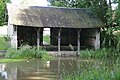
Wash house

Personalities
- Jacques de Morgan (1857-1924), Egyptologist
Web links
Commons : Huisseau-sur-Cosson - Collection of images, videos and audio files