
Candé-sur-Beuvron
| Candé-sur-Beuvron | ||
|---|---|---|
|
||
| region | Center-Val de Loire | |
| Department | Loir-et-Cher | |
| Arrondissement | Blois | |
| Canton | Blois-3 | |
| Community association | Agglomération de Blois | |
| Coordinates | 47 ° 30 ′ N , 1 ° 16 ′ E | |
| height | 62–111 m | |
| surface | 15.49 km 2 | |
| Residents | 1,497 (January 1, 2017) | |
| Population density | 97 inhabitants / km 2 | |
| Post Code | 41120 | |
| INSEE code | 41029 | |
_Mairie.JPG) Candé-sur-Beuvron |
||

Candé-sur-Beuvron is a French commune with 1,497 inhabitants (as of January 1 2017) in the department of Loir-et-Cher in the region Center-Val de Loire ; it belongs to the Arrondissement Blois and is part of the canton Blois-3 (until 2015: canton Contres ). The inhabitants are called Candéens .
geography
Candé-sur-Beuvron is about ten kilometers south-southwest of Blois on the Loire , into which the Beuvron (which previously received the Cosson ) flows into the Sologne . Candé-sur-Beuvron is surrounded by the neighboring municipalities of Valloire-sur-Cisse in the north and northwest, Chailles in the northeast, Les Montils in the east, Valaire in the south and Chaumont-sur-Loire in the southwest.
Population development
| year | 1962 | 1968 | 1975 | 1982 | 1990 | 1999 | 2006 | 2013 |
| Residents | 501 | 508 | 540 | 916 | 1,134 | 1,208 | 1,408 | 1,529 |
| Source: Cassini and INSEE | ||||||||
Attractions
- church
- Candé-sur-Beuvron castle
- Madon Castle
- Old bridge over the Beuvron

church
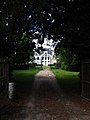
Madon Castle

Bridge over the Beuvron
_%C3%89glise_(2).JPG)

_Vieux_pont_sur_le_Beuvron.JPG)
Parish partnership
A partnership has existed with the Belgian municipality of Olne in Wallonia since 2004.