Vineuil (Loir-et-Cher)
| Vineuil | ||
|---|---|---|

|
|
|
| region | Center-Val de Loire | |
| Department | Loir-et-Cher | |
| Arrondissement | Blois | |
| Canton | Vineuil (main town) | |
| Community association | Agglomération de Blois | |
| Coordinates | 47 ° 35 ' N , 1 ° 22' E | |
| height | 68-100 m | |
| surface | 22.34 km 2 | |
| Residents | 7,815 (January 1, 2017) | |
| Population density | 350 inhabitants / km 2 | |
| Post Code | 41350 | |
| INSEE code | 41295 | |
| Website | http://www.vineuil41.fr/ | |
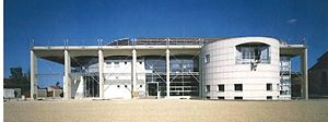
 Vineuil Town Hall |
||
Vineuil is a French municipality with 7815 inhabitants (as of January 1 2017) in the department of Loir-et-Cher in the region Center-Val de Loire ; it belongs to the arrondissement of Blois and is the main town ( chef-lieu ) of the canton of Vineuil . The inhabitants are called Vinoliennes .
geography
Vineuil is on the River Cosson . The northern municipal boundary forms the Loire . Vineuil is surrounded by the neighboring communities of Saint-Denis-sur-Loire in the north, Saint-Claude-de-Diray in the northeast, Huisseau-sur-Cosson in the east, Mont-près-Chambord in the south and southeast, Saint-Gervais-la- Forêt in the southwest, Blois in the west and La Chaussée-Saint-Victor in the northwest.
Vineuil belongs to the Cour-Cheverny wine region .
Population development
| 1962 | 1968 | 1975 | 1982 | 1990 | 1999 | 2006 | 2017 | |
|---|---|---|---|---|---|---|---|---|
| 2659 | 3466 | 4393 | 5263 | 6253 | 6651 | 6945 | 7815 | |
| Sources: Cassini and INSEE | ||||||||
Attractions
- Saint-Michel-sur-le-Cosson bridge
Personalities
- Jacques Daget (1919–2009), ichthyologist
