Binas
| Binas | ||
|---|---|---|

|
|
|
| region | Center-Val de Loire | |
| Department | Loir-et-Cher | |
| Arrondissement | Blois | |
| Canton | La Beauce | |
| Community association | Terres du Val de Loire | |
| Coordinates | 47 ° 54 ' N , 1 ° 28' E | |
| height | 120-133 m | |
| surface | 26.38 km 2 | |
| Residents | 686 (January 1, 2017) | |
| Population density | 26 inhabitants / km 2 | |
| Post Code | 41240 | |
| INSEE code | 41017 | |
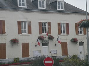
 Town hall (Mairie) of Binas |
||
Bina is a French municipality with 686 inhabitants (as of January 1 2017) in the department of Loir-et-Cher in the region Center-Val de Loire ; it belongs to the arrondissement of Blois and the canton of La Beauce (until 2015: canton of Ouzouer-le-Marché ).
geography
Binas is about 32 kilometers west of Orléans . Binas is surrounded by the neighboring communities of Verdes in the north and north-west, Tripleville in the north-east, Ouzouer-le-Marché in the east, Saint-Laurent-des-Bois in the south, Autainville in the west and south-west and Semerville in the north-west.
Here the former Routes nationales 825 (today's D925) and 826 (today's D357) intersect .
Demographic development
| 1962 | 1968 | 1975 | 1982 | 1990 | 1999 | 2006 | 2012 | |
| 866 | 813 | 746 | 689 | 601 | 593 | 689 | 722 | |
| Source: Cassini and INSEE | ||||||||
Web links
Commons : Binas - collection of images, videos and audio files
