La Chapelle-Vendômoise
| La Chapelle-Vendômoise | ||
|---|---|---|
|
|
||
| region | Center-Val de Loire | |
| Department | Loir-et-Cher | |
| Arrondissement | Blois | |
| Canton | Onzain | |
| Community association | Agglomération de Blois | |
| Coordinates | 47 ° 40 ′ N , 1 ° 14 ′ E | |
| height | 87-131 m | |
| surface | 13.07 km 2 | |
| Residents | 783 (January 1, 2017) | |
| Population density | 60 inhabitants / km 2 | |
| Post Code | 41330 | |
| INSEE code | 41040 | |
La Chapelle-Vendômoise is a French municipality with 783 inhabitants (as of January 1 2017) in the department of Loir-et-Cher in the region Center-Val de Loire . It belongs to the Arrondissement Blois , the canton Onzain (until 2015 the canton Herbault ) and the municipality association Agglomération de Blois .
geography
La Chapelle-Vendômoise is about ten kilometers north-north-west of Blois . La Chapelle-Vendômoise is surrounded by the neighboring communities of Villefrancœur in the north and west, Champigny-en-Beauce in the north and north-east, Averdon in the east, Fossé in the south-east, Saint-Bohaire in the south and Landes-le-Gaulois in the west and south-west.
Blois-Le Breuil airfield is located in the municipality .
Population development
| year | 1962 | 1968 | 1975 | 1982 | 1990 | 1999 | 2006 | 2012 |
| Residents | 424 | 421 | 553 | 623 | 708 | 744 | 747 | 721 |
| Source: Cassini and INSEE | ||||||||
Attractions
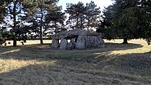
- Dolmen La Pierre Levée
- church
Web links
Commons : La Chapelle-Vendômoise - Collection of images, videos and audio files

