
Valloire-sur-Cisse
| Valloire-sur-Cisse | ||
|---|---|---|
|
||
| region | Center-Val de Loire | |
| Department | Loir-et-Cher | |
| Arrondissement | Blois | |
| Canton | Onzain | |
| Community association | Agglomeration of Blois | |
| Coordinates | 47 ° 32 ' N , 1 ° 15' E | |
| height | 61-122 m | |
| surface | 40.36 km 2 | |
| Residents | 2,438 (January 1, 2017) | |
| Population density | 60 inhabitants / km 2 | |
| Post Code | 41150 | |
| INSEE code | 41055 | |
 Town hall (Mairie) of Valloire-sur-Cisse |
||

Valloire-sur-Cisse is a French commune with 2,398 inhabitants (as of January 1 2017) in the department of Loir-et-Cher in the region Center-Val de Loire . It belongs to the arrondissement of Blois and the canton of Onzain .
location
Valloire-sur-Cisse is about nine kilometers west of Blois on the Cisse . Valloire-sur-Cisse is surrounded by the neighboring municipalities of Valencisse in the north, Blois in the northeast, Chailles in the east, Candé-sur-Beuvron in the south and southeast, Chaumont-sur-Loire in the south, Veuzain-sur-Loire in the south and southwest as well Santenay to the west and northwest.
history
On January 1, 2017, the municipality of Valloire-sur-Cisse was created as Commune nouvelle from the previously independent municipalities of Chouzy-sur-Cisse , Coulanges and Seillac .
structure
| District | former INSEE code |
Area (km²) | Population (2017) |
|---|---|---|---|
| Chouzy-sur-Cisse (administrative headquarters) | 41055 | 22.43 | 2.016 |
| Coulanges | 41064 | 8.35 | 311 |
| Seillac | 41240 | 9.58 | 111 |
Attractions
Chouzy-sur-Cisse
- Saint Martin Church
- Remains of the earlier abbey of La Guiche from the 13th century, monument historique since 1926
- Laleu Manor, a historic monument since 1937
Coulanges
- Saint-Denis church
- Rocon Castle
Seillac
- Saint-Jacques-de-Majeur church
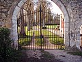
Remains of the Abbey of La Guiche

Saint-Denis church

