
Suèvres
| Suèvres | ||
|---|---|---|
.svg)
|
|
|
| region | Center-Val de Loire | |
| Department | Loir-et-Cher | |
| Arrondissement | Blois | |
| Canton | La Beauce | |
| Community association | Beauce Val de Loire | |
| Coordinates | 47 ° 40 ′ N , 1 ° 28 ′ E | |
| height | 71-119 m | |
| surface | 36.65 km 2 | |
| Residents | 1,693 (January 1, 2017) | |
| Population density | 46 inhabitants / km 2 | |
| Post Code | 41500 | |
| INSEE code | 41252 | |
| Website | http://www.mairie.suevres.com/ | |
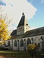
 Town hall and church of Suèvres |
||

Suèvres is a French commune with 1,693 inhabitants (as of January 1 2017) in Loir-et-Cher in the region Center-Val de Loire ; it belongs to the arrondissement of Blois and the canton of La Beauce (until 2015: canton of Mer ).
geography
Suèvres is about twelve kilometers northeast of Blois . The Loire flows on the southern edge of the municipality . Suèvres is surrounded by the neighboring communities of La Chapelle-Saint-Martin-en-Plaine in the north, Mer in the northeast, Courbouzon in the east and northeast, Muides-sur-Loire in the east and southeast, and Saint-Dyé-sur-Loire in the south and southeast , Maslives and Montlivault in the south, Cour-sur-Loire in the west and south-west and Mulsans in the west and north-west.
The A10 autoroute and the former route nationale 152 (today's D2152) run through the municipality . The municipality's train station is on the Paris – Bordeaux line .
Suèvres is a stage on the Via Turonensis , a variant of the Camino de Santiago .
Population development
| year | 1962 | 1968 | 1975 | 1982 | 1990 | 1999 | 2007 | 2012 |
| Residents | 1,234 | 1,244 | 1,147 | 1,307 | 1,360 | 1,371 | 1,439 | 1,616 |
| Source: Cassini and INSEE | ||||||||
Attractions
- Saint-Christophe church from the 12th / 13th centuries Century, alterations from the 16th century
- Saint-Lubin church from the 12th century, monument historique since 1862
- Les Forges castle
- Diziers Castle
- Grenouillère Castle
- Fortification of Suèvres
Saint-Christophe Church

Saint-Lubin Church

Grénouillère Castle


Personalities
- Philippe Fénelon (* 1952), composer
Web links