Fontaines-en-Sologne
| Fontaines-en-Sologne | ||
|---|---|---|
|
|
||
| region | Center-Val de Loire | |
| Department | Loir-et-Cher | |
| Arrondissement | Blois | |
| Canton | Chambord | |
| Community association | Grand Chambord | |
| Coordinates | 47 ° 31 ' N , 1 ° 33' E | |
| height | 80-119 m | |
| surface | 46.25 km 2 | |
| Residents | 633 (January 1, 2017) | |
| Population density | 14 inhabitants / km 2 | |
| Post Code | 41250 | |
| INSEE code | 41086 | |
Fontaines-en-Sologne is a French municipality with 633 inhabitants (as of January 1 2017) in the department of Loir-et-Cher in the region Center-Val de Loire ; it belongs to the arrondissement of Blois and is part of the canton of Chambord (until 2015: canton of Bracieux ). The inhabitants are called Saint-Claudins .
geography
Fontaines-en-Sologne is about 18 kilometers east-southeast of Blois . The Conon flows through the community . A lake landscape extends throughout the area. Fontaines-en-Sologne is surrounded by the neighboring communities of Tour-en-Sologne in the north and north-west, Bauzy in the north-east, Courmemin in the east, Mur-de-Sologne in the south-east, Soings-en-Sologne in the south, Le Controis-en-Sologne with Contres in the southwest and Cheverny and Cour-Cheverny in the west.
Population development
| 1962 | 1968 | 1975 | 1982 | 1990 | 1999 | 2006 | 2012 | |
|---|---|---|---|---|---|---|---|---|
| 765 | 781 | 706 | 568 | 520 | 519 | 566 | 642 | |
| Sources: Cassini and INSEE | ||||||||
Attractions
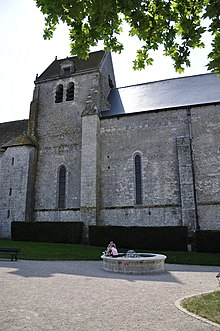
- Notre-Dame church, a historic monument since 1910
- several old houses in the center

