
Chailles
| Chailles | ||
|---|---|---|

|
|
|
| region | Center-Val de Loire | |
| Department | Loir-et-Cher | |
| Arrondissement | Blois | |
| Canton | Blois-3 | |
| Community association | Agglomération de Blois | |
| Coordinates | 47 ° 33 ' N , 1 ° 19' E | |
| height | 63-110 m | |
| surface | 18.54 km 2 | |
| Residents | 2,680 (January 1, 2017) | |
| Population density | 145 inhabitants / km 2 | |
| Post Code | 41120 | |
| INSEE code | 41032 | |
| Website | http://www.chailles41.fr/ | |

Chailles is a French commune in the department of Loir-et-Cher in the region Center-Val de Loire . The population is 2680 (as of January 1, 2017). Chailles belongs to the Arrondissement of Blois and the canton of Blois-3 (until 2015: canton of Blois-2 ). The inhabitants are called Chaillois .
geography
Chailles is located between Orléans and Tours on the Cosson , a tributary of the Loire , which forms the northwestern municipal boundary. Chailles is surrounded by the neighboring communities of Blois in the north, Saint-Gervais-la-Forêt in the northeast, Cellettes in the east, Seur in the southeast, Les Montils in the south, Candé-sur-Beuvron in the southwest and Valloire-sur-Cisse in the west and southwest .
Population development
| 1962 | 1968 | 1975 | 1982 | 1990 | 1999 | 2006 | 2012 |
|---|---|---|---|---|---|---|---|
| 769 | 1.014 | 1,249 | 1,556 | 1,602 | 2,019 | 2,377 | 2,562 |
Attractions
- Saint-Martin church, rebuilt in the 15th and 16th centuries Century, restored in the 19th century
- Le Plessis-Villelouet Castle, Monument historique
- La Pigeonnière Castle, Monument historique

Saint Martin Church

Le Plessis-Villelouet Castle
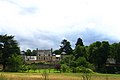
Pigeonnière Castle
_%C3%A9glise_Saint-Martin.JPG)

.jpg)
Personalities
- Colette Beaune (* 1943), mediaevalist