
Karoo Ferrar Magma Provinces
The Karoo-Ferrar magmatic provinces are two large, largely geographically separated, continental magmatic provinces , which, however, are closely related in terms of time and geodynamics . It is assumed that the cause is related to large-volume mantle convections and / or the rise of a mantle plume during the unstable plate tectonic conditions and rift formations prevailing at the time . The Karoo Magma Province originated in southern Proto- Africa , while the Ferrar Magma Province developed mainly in western Proto- East Antarctica .
The escaped magmas covered an area of around 3 million square kilometers over a period of 204 to 175 mya (million years). The ascended magma volume was estimated to be around 2.5 million cubic kilometers.
As a result of the large magma releases, lasting damage to the ecology occurred, which led to the great mass extinction at the Triassic-Jura border .
Magma springs


The igneous provinces dealt with here spread across continental land masses. Various hypotheses exist about the cause of the magma release. They are all based on the rising currents of hot magmas from the earth's mantle . An ascending mantle convection cell or a bulge of the sublithospheric mantle could be considered as the magma source . According to another hypothesis, a large-volume mantle plume transported hot material towards the earth's crust . From these main magma sources , several widely distributed sub magma chambers developed , from which spatially separate melts rose, which intruded into the earth's crust and penetrated it. This essentially resulted in flood basement areas (see also → Trapp ), storage corridors , dykes and volcanic rocks . Large-volume, rising hot magma from the earth's mantle can also lead to bulging, expansion and ultimately to separation of the lithospheric plates (see also → plate tectonics ).
During the magma ascent, changes in the original rock melt can occur due to geochemical and geophysical processes. The rocks remaining in the earth's crust and deposited on the earth's surface therefore differ significantly from region to region.

A region around the Proto- Weddell Sea is seen as the initial beginning of the two igneous provinces, where the so-called Weddell triple junction was formed. This zone lay between the then Southeast African, Southwest American and Southeastern East Antarctic continental masses. This assumption is justified by the geochemical similarities of low titanium content tholeiites in the central area of the Karoo magma province and of Ferrar magmas which are also low titanium content.
The magma rise is closely related to the later separation of East Gondwana from West Gondwana along an ocean spread that led to the opening of the Proto- Indian Ocean . The time period for ocean floor spreads between Proto-East Africa and Proto-Antarctica is given around 155 mya.
Karoo Magma Province
Geographical expansion

Location of South Africa
Provinces of South Africa

Relief map of Lesotho

Location of Swaziland

Location of Zimbabwe

Location of Mozambique
Location of Zambia

Location of Botswana
.svg)


_(Madagascar_centered).svg)
.svg)
.svg)
.svg)
.svg)
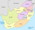
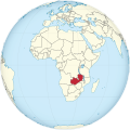
The Karoo magma province developed mainly in the Karoo main basin , which roughly corresponds to today's South Africa with the enclave of Lesotho and Swaziland . To the north and east there are separate basins that extend as far as Zimbabwe , Mozambique and Zambia and Botswana , e.g. B. the Lebombo Basin. In these magmatic processes also took place, which are assigned to the Karoo magma province. They differ lithostratigraphically and petrographically from those in the main Karoo basin.
In total, an area of approx. 3 × 10 6 km 2 was covered. The increased magma volume was estimated to be around 2.5 × 10 6 km 3 .
Magmatic sequences
.png)

The spread of magmas began around 204 mya in the extreme southeast of present-day Africa with minor nephelinitischen , carbonatite sills in Zimbabwe and the Kruger National Park the extreme north-east of South Africa , kimberlite - chimneys (pipes) in the northeastern Swaziland and KwaZulu-Natal , alkaline basalts and Basaniten in North of the Lubombo region of Swaziland as well as in western Zambia . This was followed by 184 to 175, the main magmatic phase in the predominantly tholeiitic - basalts were released. These are widespread in southern and southeastern African areas. They were regionally covered by rhyolite volcanic rocks .
In the Karoo Magma Province, the mostly basaltic lava layers that have risen to the surface and deposited there are dominant. Due to their extensive spread, these are also known as flood basalts . They developed from a large number of individual, relatively thin layers, which, however, grew over a period of approx. 10 million years to a total thickness of approx. 1.5 km.
Within the entire Karoo main basin intruded a plurality of doleritischen sills the basaltic materials, while at the edges of four extensive doleritic Dykeschwärme developed. They start from a virtual exit area, the Karoo Triple Junction, and run from there radially in different directions. This area can be assigned to the Mwenezi district in southern Zimbabwe near the border with Botswana . The Okavango Dyke swarm is the largest with a length of around 1,500 km. It extends in a north-westerly direction from Zimbabwe to Botswana.
The composition of the basalts is relatively uniform with only minor chemical variations. They are divided according to their titanium and zirconium concentrations. Basalts with a low titanic content occur mainly south of the 26th parallel (around Johannesburg ), the others north of it.
Lithostratigraphy

Geological map of the Karoo supergroup with the regions of the Karoo magma province shown in dark blue

SW / NE cross-section through South Africa with the magmas of the Karoo magma province shown in dark blue


The Karoo Magma Province forms the supreme lithostratigraphic unit of the Karoo supergroup . It includes the Drakensberg Group and the Lebombo Group. These cover the older sedimentary deposits, such as the Stormberg Group, which were deposited in a terrestrial sedimentary basin influenced by rivers and inland waters .
Drakensberg Group


The Drakensberg Group consists predominantly of basaltic magmas that rose across long, crack-like crevices. The Drakenberg Group's igneous rocks are based on several thick sedimentary sequences that have been deposited in a continental depression called the Karoo Main Basin since the late Carboniferous ( Pennsylvania ) . On the surface they formed a multitude of almost horizontal lava flows between 10 and 50 meters thick , which accumulated over a period of around 10 million years to a thickness of up to 1.5 km. Magmas extruded variously under high pressure between horizontal rock layers of the deeply underlying sedimentary Ecca and Beaufort groups, where they formed several dolerite dykes or dykes. The thickness of these storage corridors varies from a few centimeters to hundreds of meters. (see also → Drakensberg Group (Drakensberg Group) ).
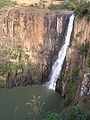
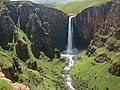
Particularly striking geological units of the Drakensberg Group are the Drakensberg and Victoria Falls , in which basaltic rock formations come to light.
- Drakensberg

Panorama of the Giant's Castle of the Drakensberg in KwaZulu-Natal

Rock formations in the amphitheater Drakensberg in the Royal Natal National Park / KwaZulu-Natal

Steep, vertically split Drakensberg basalt, deposited on the uppermost sandstone formation of the Stormberg Group in the province of Free State

At 3,482 meters, the Thabana Ntlenyana is the highest mountain in the Drakensberg
The 119 m high Howick Falls of the Mngeni River in KwaZulu-Natal on the cliff of the basaltic storage corridors in KwaZulu-Natal
The 192 m high Maletsunyane waterfall in the basalts of the Drakensberg in Lesotho ,


.jpg)


The Drakensberg range from the Eastern Cape via Lesotho , KwaZulu-Natal , Free State , Mpumalanga to the city of Tzaneen in Limpopo over a length of approx. 1,000 km. To the Indian Ocean they drop off steeply in a large edge step ( Drakensberg Escarpment ). The uppermost formation is formed by low-titanium basalts. These occur only on the northeast and eastern borders of Lesotho and the Eastern Cape. The entire lithostratigraphy of the Karoo main basin is exposed there. The highest peaks reach heights of over 3,450 meters, of which the Thabana Ntlenyana is the highest at 3,482 meters. Various dykes and dikes intruded into the tholeiitic basalts. In some places eroded out corridors form the basis of waterfalls , such as B. the 119 meter high Howick Falls and the 192 meter high Maletsunyane waterfall .
- Victoria Falls

Catchment area of the Zambezi with lettering of Victoria Falls , Makgadikgadi salt pans and the Okavango Delta

Satellite image of Victoria Falls in the flood basalts of the Batoka Formation

Canyons in the flood basalts near Victoria Falls


The Victoria Falls are the largest waterfalls in Africa and extend in the Zambezi Valley between the border towns of Victoria Falls in Zimbabwe and Livingstone in Zambia . The Victoria Falls are formed by the ongoing backward erosion of the plateau of the basaltic Batoka Formation by the Zambezi in the southern part of the southern province of Zambia and the adjacent area in Zimbabwe. The Batoka Formation has a right-angled system of fissures that intersects like a grid. As a result of the Zambezi erosion, gorges up to 108 meters deep formed in this area . The clefts , which were originally filled with sediments, have now eroded again.

Originally the Zambezi flowed into the Limpopo . The area between Zimbabwe and Botswana rose more than 5 mya, blocking the Proto-Zambezi and damming Lake Makgadikgadi with no outflow . About 20,000 years ago it began to drain through the clefts of the Batoka Formation and form today's waterfalls and gorges . The original Zambezi created a new bed and finally flowed into the Indian Ocean. Relics of Lake Makgadikgadi are today's Makgadikgadi Salt Pans and the Okavango Delta , which was originally part of Lake Makgadikgadi.


The Batoka Formation consists of basalts and occurs in Botswana , Zimbabwe and Zambia in the central reaches of the Zambezi as well as in the Mana Pools National Park and the Cahora Bassa Basin . These form separate pools outside of the main Karoo pool. The basalts of the Batoka Formation are associated with the occurrence of the basalts of the Drakensberg Group in the Karoo main basin. The Batoka formation there is the top formation in the Upper Karoo Group of the Karoo supergroup. The tholeiitic basalts emerge in a sequence of several relatively thin, almost horizontal layers. There are no sedimentary horizons between the magma eruptions. The basalts have relatively high titanium and low potassium contents . This distinguishes them from the low-titanium basalts of the Drakensberg Group further south. The lavas are dark, vesicular and porphyritic or massive basalts with occasional pillow lavas . Dazite and rhyolites occur occasionally . With an age of 180 to 179 mya they fall into the late phase of Karoo magmatism.
Lebombo group
The Lebombo group developed in the Lebombo Basin, which connects to the northeast of the Karoo Main Basin and runs from there in a northerly direction. It represents a rift system that developed as a result of the incipient separation of Proto-West Africa (Kalahari or Kaapvaal craton ) from Proto-East Antarctica ( Queen Marie Land ).
Lithostratigraphically, this group consists of a sequence of magmatic and volcanic deposits that developed on the Clarens sandstone formation of the Stormberg Group . The basal, 170 meters thick layer consists of igneous nephelinite . It was followed by several widespread basaltic / pikritische Lavasequenzen, the cumulative total of 6,000 meters in thickness. Sequences of volcanic rhyodacites and rhyolites up to 5,000 meters thick intruded into these, mainly in central and southern sections , followed by further basaltic lavas. Several mafic dykes and storage tunnels penetrated these volcanic rocks and magmatites . Geochemically, the lavas differ in their titanium content. Low titanic rocks occur only south of the Sabie River , while high titanic rocks only exist north of the Komati River. In the transition zone, which is about 60 km wide, both types of rock intermesh. The magmatic / volcanic processes date from 182 to 178 mya.
Geomorphologically , the deposits in the Lebombo Basin form a seaward sloping monocline , which was connected to the East Antarctic Explora Escarpment off the Princess Martha coast of the East Antarctic Queen Maud Land before the separation between East and West Gondwana . It correlates especially with the local westward inclined Kraul Mountains (Vestfjella Mountains).

The Lebombo Mountains are named after the Lebombo Group . They extend from the city of Hluhluwe in KwaZulu-Natal via Limpopo to Swaziland and Mozambique . They form an approximately 600 km long, narrow chain of mountainous to hilly elevations between 400 and 800 meters in length, which were created as a result of erosion from what were once significantly higher mountains. These elevations are the relics of the rhyolite volcanic eruptions. The differently eroded volcanic rocks form a series of almost parallel, sharp strata that are separated from one another by savanna plains. The latter result from the even more heavily eroded basaltic lava deposits. The area is surrounded by numerous dolerite - Dykes crossed. On the western edge of the Lebombo Mountains are u. a. the Kruger National Park and the Nature Park Phongolo Nature Reserve .
Karoo Magmas in East Antarctica

Antarctica with Queen Marie Land in the north

Location of Queen Marie Land

Location of the African Kaapvaal craton

Location of the East Antarctic Grunehogna Craton with geological regions and structures


Karoo basalts can also be found in today's East Antarctic Queen Maud Land (Dronning Maud Land), as the African Kalahari or Kaapvaal craton had tectonic contact with the Antarctic Grunehogna craton at that time. Notable igneous intrusions in the Queen Marie Land occurred in the Kraulberge (Vestfjella), Ahlmannryggen ( Ahlmann Ridge ), Heimefrontfjella , Kirwanveggen , as well as in the undersea Explora Escarpment .
As can be seen from petrological analyzes, these have similar geochemical signatures as the African tholeiitschen basalts and picrites in the area of the Batoka Formation and the Lebombo Mountains.
Ferrar Magma Province
.jpg)
In the Lower Jurassic , an elongated stretch zone was created on the southern continental flank of Proto-East Antarctica between the Theron Mountains in Coatsland and the Horn Bluff - cliff off the Georg V coast . This course corresponds roughly to the Ross Orogen or today's Transantarctic Mountains . It is continued in the south-east of Proto-Australia with today's Tasmania and in Proto- New Zealand or Zealandia .
In this expansion zone, a Magmatic Greater Province developed between 184 and 175 mya . It got its name after the geologist Hartley Travers Ferrar and is therefore referred to as Ferrar Large Ingeous Province (FLIP for short). The FLIP essentially comprises the Dufek intrusion , the Ferrar dolerite , volcanic rocks from pyroclastic flows and the Kirkpatrick basalts . Lithostratigraphically they form the Ferrar supergroup.
The Ferrar magmas invaded the Ross orogen basement along the Paleo-Pacific Gondwana rim. However, most of the reservoir dikes intruded into the deformed supracrustal rocks, such as the sandstone layers of the Beacon Supergroup .
Dufek intrusion
.jpg)

The Dufek intrusion occurs in the Dufek massif and the Forrestal Range, as well as in many neighboring nunataks (rock formations rising from glaciers) in the northern Pensacola Mountains near the Filchner-Ronne Ice Shelf . It covers an assumed area of up to 34,000 km 2 with an estimated thickness of up to approx. 9 km. Large areas are hidden under ice. The intrusion body consists of a large number of predominantly subhorizontal, well-layered storage tunnels . Dykes developed on the edges of the intrusion bodies.
The Dufek intrusion represents a differentiated , layered magmatic bedrock complex, which consists mainly of pyroxene - gabbros and magnetites . The top formation is formed by 300 meters thick Granophyr deposits. Textures and structures indicate that most igneous rocks are cumulates . These consist of a variable number of uniform plagioclases and pyroxenes in two different compositions. They formed in magma chambers during fractional crystallization .
Ferrar dolerite
The Ferrar dolerites are among the most important rock deposits in East Antarctica. Along the Transantarctic Mountains they are exposed as well-developed, doleritic rock formations up to several 100 meters high , which mainly consist of subhorizontal storage corridors of varying thickness. Regionally, they were intruded by Dykes in a planar manner ( sheet intrusion ). The Ferrar dolerites are characterized by their widespread occurrence of approx. 4,500 km and their relatively uniform geochemical composition. From the geochemical analyzes and the isotope investigation it was concluded that the earth's mantle magam source was remarkably uniform. This could be with the subduction of terrestrial sediments in a to inkompaktiblen elements depleted sheath reservoir ( Depleted (MORB) Mantle are connected).
Volcanites
Volcanic rocks are widespread in the Ferrar Magma province. The basal Hanson Formation in the central Transantarctic Mountains consists of approx. 240 meters thick silicon dioxide-containing tuffs , tuff-like sandstones and low-proportion quartz sandstones . Temporally it is assigned to the Lower Jurassic . It is covered by basaltic pyroclastic rocks of the Prebble Formation. Similar basalt rocks also occur in East Antarctica Victoria Land and form the Mawson and Exposure Hill formations. The silicate and basaltic pyroclastic components are composed of thick tuff breccias with subordinate lapilli tuffs and tuff stones. They document the transition from fluvial sedimentation in a foreland basin to a tectonic extension regime that is associated with the occurrence of flood basalts and the Gondwana collapse. The deposited sequences are up to 400 meters thick. These pyroclastic basalt rocks and the Kirkpatrick basalt lavas above come from the Middle Jurassic .
Kirkpatrick basalts
Mount Joyce in the Prince Albert Mountains

Ross Ice Shelf with the Queen Alexandra Chain

Map of the Mesa Range as well as the Southern Cross Mountains and Mountaineer Range


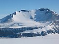
The Kirkpatrick basalts occur from central to southern areas of the Transantarctic Mountains. They appear as outcrops of several mountains or mountain ranges that protrude from the ice sheet as nunataks . There are z. B. the Queen Alexandra chain , the Prince Albert Mountains and the Mesa Range . The basalts differ in terms of their spread from the doleritic camps in that they did not take place within existing deposits like these, but formed superficial ( subaeric ) lava basalt flows. The base of the Kirkpatrick basalts developed on a sequence of pillow lavas and pyroclasts that cover the deposits of the Beacon Supergroup . The basalt currents, which consist of several layers, accumulated to an assumed total thickness of up to 1,000 meters with only minor inclusions of sediments. The almost horizontally deposited basalt currents form the uppermost lithostratigraphic unit of the Ferrar supergroup and show no deformations. Petrographically , the Kirkpatrick basalts have typical characteristics of continental flood basalts. Based on the main and trace elements, they can be geochemically divided into a lower and an upper magma sequence. In fractional crystallization, the magmas in the lower one are more contaminated by crustal material than the upper one. This also has a more homogeneous composition.
Mass extinction
During the Karoo-Ferrar magma releases, the early Jurassic extinction event occurred on the Triassic-Jura border . Other magmatic provinces such as B. the Central Atlantic Magmatic Province from 202 to 143 mya and the Western Tethys Province from 207 to 159 mya. One of the hypotheses links global death rates with the long-lasting, intense magma outflows. As a rule, these have harmful effects on regional or even global ecology . They are associated with environmental and climate effects , such as B. Global warming , oxygen depletion of near-surface sea water layers (see also → oceanic anoxic events ), calcification crises in the tissues of living beings, mass extinction and with increased release of gas hydrates , which in turn exerts an additional strong influence.

Examples of conodont fossils

Skeletal reconstruction of the theropod Cryolophosaurus

Life reconstruction of Glacialisaurus

Life reconstruction of Massospondylus
Life reconstruction of Melanorosaurus

Fossil of a Heterodontosaurus

Heterodontosaurus localities in South Africa and Lesotho


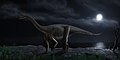
The mass extinction on the Triassic-Jura border probably fell victim to around 50 percent of all taxa of that time . The class of marine conodonts , which disappeared completely, was hit hardest . Furthermore, a fifth of the marine families of that time were also wiped out. From the terrestrial living faunas died except for the crocodiles all major crurotarsi (not to the dinosaurs belonging Archosauria ) from; also some of the amphibious representatives of the genus Temnospondyli such as Capitosauria . Fish and marine reptiles have experienced a significant decline without becoming extinct. The first representatives of the dinosaurs also disappeared, such as the theropod Cryolophosaurus from Mount Kirkpatrick and the sauropodomorph Glacialisaurus from the central Transantarctic Mountains as well as Massospondylus from South Africa, Lesotho, Zimbabwe, Melanorosaurus , Blikanasaurus and Heterodontosaurus from the order bird-pelvis dinosaur from South Africa.
The ecological niches that became vacant were mainly occupied by the later and more highly developed dinosaurs . They include u. a. the bird pelvic dinosaur and lizard dinosaur with the theropoda . The pterosaurs also developed significantly. One of the most remarkable evolutions during this period was the appearance of the first real mammals (see → also evolution of mammals ).
Web links
- Large Igneous Provinces Commission, International Association of Volcanology and Chemistry of the Earth's Interior [4]
- Richard E. Ernst and Kenneth L. Buchan: Database of LIPs through time. [5]
- TH Torsvik, C. Gaina and TF Redfield: Antacktica and Glopbal Paleography: From Rodinia, Through Gondwanaland and Pangea, to the Birth of the Southern Ocean an Opening of Gateways. In: Antarctica: A Keystone in a Changing World (2008). section
- AB Ford and DL Schmidt: The Antarctic and Its Geology. In: US Government Printing Office Washington, DC 20402. PDF
- Vincent E. Courtillot and Paul R. Renne: On the ages of flood basalt events. In: CR Geoscience 335 (2003) 113-140. doi: 10.1016 / S1631-0713 (03) 00006-3 , alternatively
- K. Gohl, G. Uenzelmann-Neben, N. Grobys: Growth and dispersal of a southeast African large igneous province. In: South African Journal of Geology, 114 (3-4): 379-38, January 2012. doi: 10.2113 / gssajg.114.3-4.379 , alternative
- David PG Bond and Paul B. Wignall: Large igneous provinces and mass extinctions: An update. In: The Geological Society of America, Special Paper 505, 2014. doi: 10.1130 / 2014.2505 (02) , alternative
Individual evidence
- ↑ Jussi S. Heinonen and Arto V. Luttinen: The highly magnesian dike rocks of Vestfjella (western Dronning Maud Land, Antarctica): implications for sublithospheric mantle sources and the origin of the Karoo large igneous province. In: MantlePlumes.org website. Online article
- ↑ a b c A. Segev: Flood basalts, continental breakup and the dispersal of Gondwana: evidence for periodic migration of upwelling mantle flows (plumes). In: European Geosciences Union 2002, Stephan Mueller Special Publication Series, 2, 171–191, 2002. PDF
- ^ David Elliot and Thomas H. Fleming: Weddell triple junction: The principal focus of Ferrar and Karoo magmatism during initial breakup of Gondwana. In: Article in Geology 28 (6): 539-542, January 2000. [[10.1130 / 0091-7613 (2000) 28 <539: WTJTPF> 2.0.CO; 2]], alternative
- ↑ Maria Seton, Dietmar Müller, Sabin Zahirovic and Michael T. Chandler and others: Global continental and ocean basin reconstructions since 200 Ma. In: Earth-Science Reviews 113 (3-4): 212-270 • July 2012. doi: 10.1016 / j.earscirev.2012.03.002 , alternatively
- ↑ a b c O. Catuneanu, H. Wopfner, PG Eriksson, B. Cairncross and others: The Karoo basins of south-central Africa. In: Journal of African Earth Sciences 43 (2005) 211-253. doi: 10.1016 / j.jafrearsci.2005.07.007 , PDF
- ^ André Coetzee and Alex FM Kisters: The elusive feeders of the Karoo Large Igneous Province and their structural controls. In: Article in Tectonophysics 747 • September 2018. doi: 10.1016 / j.tecto.2018.09.007 , alternatively
- ↑ F. Jourdan, G. Féraud and H. Bertrand: Basement control on dyke distribution in Large Igneous Provinces: Case study of the Karoo triple junction. In: Article in MantlePlumes.org, February 2006. Online article
- ↑ Bernard Le Gall, Gomotsang Tshoso, Jérôme Dyment, Ali Basira Kampunzu and others: The Okavango giant mafic dyke swarm (NE Botswana): its structural significance within the Karoo Large Igneous Province. In: online article. [1]
- ^ GA Botha and R. Singh: Geology, geohydrology and Development Potential Zonation of the uThukela District Municipality; specialist contribution towards the Environmental Management Framework. In: Council for Geoscience online article, KwaZulu-Natal unit. PDF
- ↑ Evelyn Mervine: KwaZulu-Natal Holiday: Howick Falls. In: Geoblog in AGU Blogosphere, April 18, 2016. Online article
- ^ The Formation of the Victoria Falls. In: Website of the Zambezi Book Company. [2]
- ^ Paul Steyn: How Was the Okavango Delta Formed? In: National Geographic Society Online Article, January 17, 2017. Online Article
- ^ DL Jones, RA Duncan, JC Briden, DE Randall and C. MacNiocaill: Age of the Batoka basalts, northern Zimbabwe, and the duration of Karoo Large Igneous Province magmatism. In: Geochemistry, Geophysics, Geosystems, February 2001. doi: 10.1029 / 2000gc000110 .
- ↑ DSM Shoko and O. Gwavava: Is magmatic underplating the cause of post-rift uplift and erosion within the Cabora Bassa Basin, Zambezi Rift, Zimbabwe? In: J'ournal of African Earth Sciences, Volume 28, Issue 2, February 1999, Pages 465-485. doi: 10.1016 / S0899-5362 (99) 00015-9 , alternatively
- ↑ Tuomo Manninen, Toni Eerola, Hannu Mäkitie, Saku Vuori and others: The Karoo Volcanic Rocks and Related Intrusions in Southern and Central Mozambique. In: Geological Survey of Finland, Special Paper 48, 211–250, 2008. Online article
- ^ W. Bauer, RJ Thomas and J. Jacobs: Proterozoic-Cambrian history of Dronning Maud Land in the context of Gondwana assembly. In: Download from http://sp.lyellcollection.org/https://sp.lyellcollection.org/ at Pennsylvania State University on September 17, 2016. PDF
- ↑ Jussi S. Heinonen, Richard W. Carlson and AV Luttinen: Isotopic (Sr, Nd, Pb, and Os) composition of highly magnesian dikes of Vestfjella, western Dronning Maud Land, Antarctica: a key to the origins of the Jurassic Karoo large igneous province? In: Chemical Geology 277: 227-244, October 2013. doi: 10.1016 / j.chemgeo.2010.08.004 , alternative
- ↑ Matithas Peters: The volcanics in the western and central Neuschwabenland, Vestfjella and Ahlmannryggen, Antarctica: petrography, geochemistry, geochronology, paleomagnetism, geotectonic implications. In: Reports on Polar and Marine Research, Alfred Wegener Institute for Polar and Marine Research. doi: 10.2312 / BzP_0061_1989 , alternatively
- ↑ Peter Schulze: Petrogenesis of the metamorphic basement of the central Heimefrontjella (western Dronning Maud Land / Antarctica). In: Reports on Polar Research = Reports on Polar Research, Alfred Wegener Institute for Polar and Marine Research. doi: 10.2312 / BzP_0117_1992 .
- ^ Philip David Harris: The geological Evolution of Neumayerskarvet in the northern Kirwanveggen, western Dronning Maud Land, Antarctica. In: Thesis Submitted in fulfillment of the requirements for the degree Doctorate in Geology in the Faculty of Science at the Rand Afrikaans University. PDF
- ↑ Chris Harris, Julin S. Marsh, Andrew R. Ducan, and Anthony J. Erlank: The Petrogenesis of the Kirwan Basalts of Dronning Maud Land, Antarctica. In: Journal of Petrology, Volume 31, Issue 2, April 1990, Pages 341-369. doi: 10.1093 / petrology / 31.2.341 , alternatively
- ↑ Yngve Kristoffersen, Coen Hofstede, Anja Diez, Richard Blenkner, Astrid Lambrecht, Christoph Mayer and Olaf Eisen: Reassembling Gondwana: A new high quality constraint from vibroseis exploration of the sub ‐ ice shelf geology of the East Antarctic continental margin. In: JGR Solid Earth, Research Article, Vulume 119, Issue 12, December 2014. doi: 10.1002 / 2014JB011479 .
- ↑ Elliot, DH; Fleming, TH; Foland, ICA; Zhang, X. Establishing contemporaneity and duration of magmatism in the Jurassic Gondwana Large Igneous Province. In: Earth System Processes - Global Meeting. Edinburgh. Retrieved 13 January 2018. Online article
- ^ Arthur B. Ford: Stratigraphy of the Layered Gabbroic Dufek Intrusion, Antarctica. In: Geological Survey Bulletin 1405-D. PDF
- ↑ Janet M. Hergt, Bruce W. Chappell, Gunter Faure and Teresa M. Mensing: The geochemistry of Jurassic dolerites from Portal Peak, Antarctica. In: Contributions to Mineralogy and Petrology, July 1989, Volume 102, Issue 3, pp 298-305. doi: 10.1007 / BF00373722
- ^ DH Elliot: Stratigraphy of Jurassic pyroclastic rocks in the Transantarctic Mountains. In: Journal of African Earth Sciences, Volume 31, Issue 1, July 2000, Pages 77-89. doi: 10.1016 / S0899-5362 (00) 00074-9 , alternatively
- ^ DH Elliot, M. Siders, C. Faure and KS Taylor: The Kirkpatrick Basalt, Mesa Range, northern Victoria Land. In: Antarctic Journal 1982. PDF
- ^ Teresa Marie Mensing: Geology and petrogenesis of the Kirkpatrick Basalt, Pain Mesa and Solo Nunatak, northern Victoria Land, Antarctica. In: Dissertation Abstracts International, Volume: 48-09, Section: B, page: 2585, Thesis (Ph.D.), The Ohio State University, 1987. [3]
- ^ Bryan C. Storey, Alan PM Vaughan and Teal R. Riley: The links between large igneous provinces, continental break-up and environmental change: Evidence reviewed from Antarctica. In: Earth and Environmental Science Transactions of the Royal Society of Edinburgh, Volume 104, Issue 01, March 2013, pp 17 - 30. doi: 10.1017 / S175569101300011X , alternative