Torontál county
|
Torontal County (Torontál) (1910) |
|
|---|---|

|
|
| Administrative headquarters : | Nagybecskerek |
| Area : | 10,016 km² |
| Population : | 615.151 |
| Ethnic groups : | 199,750 Serbs 165,779 Germans 128,405 Hungarians 86,937 Romanians 16,143 Slovaks 4,203 Croats 13,934 Bulgarians , Roma a . a. |

|
|
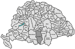
The County Torontál (Hungarian vármegye Torontál , Latin Comitatus Torontaliensis ) was a county (regional administrative unit) in the historic Kingdom of Hungary .
location
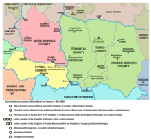
Its territory lay in the historical Banat and bordered on the south with the Kingdom of Serbia , in the west on Syrmia and Bács-Bodrog counties, in the north on the counties Csongrád and Csanád counties , in the north-east on a short distance with Arad county and in the east to Temes County . The Danube represented the southern border, the Tisza the western border and the eastern border the Marosch .
history
The county was established in the High Middle Ages . After the first Austrian Turkish War , the area came to the Ottoman Eyâlet Tımışvar in 1552 and to the Temescher Banat in 1718 with the Peace of Passarowitz . In 1778 it became a county of the Kingdom of Hungary again with its original name . After the revolution of 1848/49 it was affiliated to the Voivodeship of Serbia and the Temesian Banat until 1860 and then restored as a county. Since 1872 the southwestern part of the Banat military border belonged to the county. Torontál County had one of the most ethnically diverse populations of all administrative districts of the Danube Monarchy .
Shortly before the end of the First World War in 1918, the Banat Republic was established in the area . In the Treaty of Trianon , however, this was divided between the Kingdom of Serbs, Croats and Slovenes in the south (the largest part), Romania in the north and Hungary (small area south of Szeged).
While the Yugoslav part was incorporated into Vojvodina (with the exception of a small part near Belgrade, which belongs to the city of Belgrade and thus to central Serbia ), the Romanian part of the former county is now in the Romanian Timiș district , the small Hungarian part is now part of the county Csongrád .
District subdivision
In the early 20th century the following chair districts existed (mostly named after the name of the administrative seat):
| Chair districts (járások) | |
|---|---|
| Chair district | Administrative headquarters |
| Alibunár | Alibunár, today Алибунар / Alibunar |
| Antalfalva | Antalfalva, today Ковачица / Kovačica |
| Bánlak | Bánlak, today Banloc |
| Csene | Csene, today Cenei |
| Módos | Módos (Модош / Modoš), today Јаша Томић / Jaša Tomić |
| Nagybecskerek | Nagybecskerek (Велики Бечкерек / Veliki Bečkerek), today Зрењанин / Zrenjanin |
| Nagykikinda | Nagykikinda (Велика Кикинда / Velika Kikinda), today Кикинда / Kikinda |
| Nagyszentmiklós | Nagyszentmiklós, today Sânnicolau Mare |
| Pancsova | Pancsova, today Панчево / Pančevo |
| Párdány | Párdány (Пардањ / Párdány), today Међа / Međa |
| Perjámos | Perjámos, today Periam |
| Törökbecse | Törökbecse, today Нови Бечеј / Novi Bečej |
| Törökkanizsa | Törökkanizsa, today Нови Кнежевац / Novi Kneževac |
| Zsombolya | Zsombolya, now Jimbolia |
| City district (törvényhatósági jogú város) | |
| Pancsova, today Панчево / Pančevo | |
| City districts (rendezett tanácsú városok) | |
| Nagybecskerek (Велики Бечкерек / Veliki Bečkerek), today Зрењанин / Zrenjanin | |
| Nagykikinda (Велика Кикинда / Velika Kikinda), today Кикинда / Kikinda | |
The places Banloc , Cenei , Sânnicolau Mare , Periam and Jimbolia are in present-day Romania , the remaining places in present-day Serbia .
See also
Web links
- Map of Toronto Valley County
- Entry on the county in Meyers Konversationslexikon from 1888
- Entry in the Pallas Lexicon (Hungarian)
Individual evidence
- ↑ A magyar szent corona országainak 1910. évi népszámlálása . Budapest 1912, p. 12 ff.
- ↑ A magyar szent corona országainak 1910. évi népszámlálása . Budapest 1912, p. 22 ff. (1910 census)
- ^ Johann Heinrich Schwicker : History of the Temeser Banat . Bettelheim Verlag, Großbetschkerek 1861. Pages 39, 40, 55 and 56.


