
Olloix
| Olloix | ||
|---|---|---|

|
|
|
| region | Auvergne-Rhône-Alpes | |
| Department | Puy-de-Dôme | |
| Arrondissement | Clermont-Ferrand | |
| Canton | Orcines | |
| Community association | Mond'Arverne Communauté | |
| Coordinates | 45 ° 37 ′ N , 3 ° 4 ′ E | |
| height | 520-1,002 m | |
| surface | 11.92 km 2 | |
| Residents | 315 (January 1, 2017) | |
| Population density | 26 inhabitants / km 2 | |
| Post Code | 63450 | |
| INSEE code | 63259 | |
| Website | http://www.olloix.fr/ | |

Olloix is a French municipality with 315 inhabitants (as of January 1 2017) in the department of Puy-de-Dôme in the region Auvergne Rhône-Alpes . Olloix belongs to the arrondissement of Clermont-Ferrand and the canton of Orcines (until 2015: canton of Saint-Amant-Tallende ).
geography
Olloix is located about 17 kilometers south-southwest of Clermont-Ferrand . The municipality is bordered to the north by the Monne river . Olloix is surrounded by the neighboring municipalities of Cournols in the north, Saint-Saturnin in the northeast, Saint-Sandoux in the east and northeast, Ludesse in the east and southeast, Montagiut-le-Blanc in the south and Saint-Nectaire in the west and southwest.
In the municipality are the peaks of the Puy d'Olloix (1,002 m), Ozenne (914 m) and Marquerole (840 m).
population
| year | 1962 | 1968 | 1975 | 1982 | 1990 | 1999 | 2006 | 2012 |
|---|---|---|---|---|---|---|---|---|
| Residents | 197 | 174 | 170 | 195 | 191 | 227 | 288 | 316 |
Attractions
- Saint-Jean-Baptiste church
- Remains of the former headquarters of the Order of St. John

Headquarters of the Order of St. John
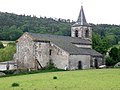
Saint-Jean-Baptiste church

